


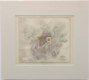
Hand-Drawn Map of Jerusalem, 1940s
Similar Sale History
![[MANUSCRIPT MAP-MAINE] After DES BARRES, JOSEPH FREDERICK WALLET. Hand-drawn map of a portion of the: [MANUSCRIPT MAP-MAINE] After DES BARRES, JOSEPH FREDERICK WALLET. Hand-drawn map of a portion of the Maine coast off Falmouth, copied from Des Barres. Likely early 19th century. Manuscript map in blac](https://p1.liveauctioneers.com/292/250642/130213649_1_x.jpg?height=310&quality=70&version=1654271664)


Recommended Items
![[PICTORIAL MAPS – TRAVEL]. Three Pictorial Maps. 1940s/50s....: [PICTORIAL MAPS – TRAVEL]. Three Pictorial Maps. 1940s/50s. Three brochure sized foldout maps designed for travel including: Highroads to Happiness. Mexico City: Pemex Travel Club, ca. 1940s. &#](https://p1.liveauctioneers.com/928/325952/175495561_1_x.jpg?height=310&quality=70&version=1712935174)


Item Details
Description
Hand-drawn map of Jerusalem, ink on cloth-like paper, ca. mid 1940s.
On upper right side: "Jerusalem" and the verse -"If I forget thee Jerusalem…" The map is drawn by hand, in clear and precise handwriting. Numerous sites are marked on the map: the Ophel, the Wall prior to the destruction, railway station in the German Colony, Army barracks in Bak'a, The Jewish Agency building next to King George Street and Palace Hotel. On the upper left a small scale map of the Jerusalem vicinity with different marks for Jewish and Arab settlements.
51X41 cm, good condition.
Buyer's Premium
- 23%
Hand-Drawn Map of Jerusalem, 1940s
Estimate $400 - $600
Shipping & Pickup Options
Item located in Jerusalem, ilSee Policy for Shipping
Payment

Related Searches
TOP