


[France-Belgium-Luxembourg, Maps] Carte Taride, 1904
Similar Sale History
View More Items in Militaria & War Memorabilia


Related Militaria & War Memorabilia


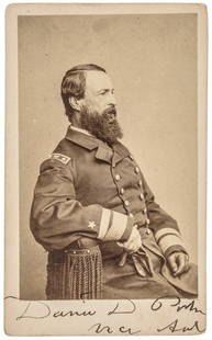
![[CIVIL WAR] Black Soldier CDV: c. 1863 Carte de visite portrait of a seated Civil War African American soldier. Photographer: Edwin Allen of New Orleans, Louisiana. Wonderful portrait of a seated of African American Civil War soldi](https://p1.liveauctioneers.com/7226/322253/173251672_1_x.jpg?height=310&quality=70&version=1710004847)
![Western Album w/ Lincoln & Rare Views [Kansas]: 40+ carte de visite portraits housed in a Civil War era photograph album. Most of the views are of civilian subjects with photographer's imprints from Chicago, Illinois, Springfield, Illinois, Kansas,](https://p1.liveauctioneers.com/7226/322253/173251612_1_x.jpg?height=310&quality=70&version=1710004847)


![Portrait of J.E.B Stuart, Sold in London: Seated three-quarter length albumen oval carte de visite (CDV) of J.E.B. Stuart. London: Alexander Bassano. [Florida]: S.C. McIntyre. McIntyre's publisher imprint and copyright notice printed in negat](https://p1.liveauctioneers.com/7226/325455/175169131_1_x.jpg?height=310&quality=70&version=1712370394)
![[CIVIL WAR] 64th Ohio CDV Album: Charming carte de visite (CDV) photograph album containing images of 10 members of the 64th Ohio Infantry. Several of the soldiers are identified; other cartes feature period inscriptions. Originally](https://p1.liveauctioneers.com/7226/325455/175169009_1_x.jpg?height=310&quality=70&version=1712370394)


More Items in Militaria & War Memorabilia
View More


![George Washington Signed Discharge: Partly printed discharge document signed by George Washington, as Commander in Chief of the Armies of the United States. Newburgh, [New York], 4 January 1783. 1 page, ## x ## in. Undersigned by Washin](https://p1.liveauctioneers.com/7226/322253/173251475_1_x.jpg?height=310&quality=70&version=1710004847)
![[Ambrotype] Texas Confederate Soldier: Sixth plate ambrotype. Full leatherette case. Portrait of a possible Texas Confederate soldier. A silver star device was used to pin up the brim of his light-toned headgear, a look often seen in image](https://p1.liveauctioneers.com/7226/322253/173251509_1_x.jpg?height=310&quality=70&version=1710004847)
![[CIVIL WAR] 1st Texas Infantry in Camp: Outdoor half plate ambrotype of the 1st Texas Infantry. Full leatherette case. Significant, large half plate ambrotype of members of the 1st Texas Infantry at ‘Splinterville,’ the regiment’s win](https://p1.liveauctioneers.com/7226/322253/173251512_1_x.jpg?height=310&quality=70&version=1710004847)
![Captured Bowie Knife w/ Period Note of Provenance: Captured Confederate D-hilt Bowie knife. [Kenansville, North Carolina]: [Louis Froelich factory]. With original metal and leather sheath with affixed period notes. First note with only remnants. Secon](https://p1.liveauctioneers.com/7226/325455/175169154_1_x.jpg?height=310&quality=70&version=1712370394)
![[HANCOCK, John] Washington’s Spy, Officer’s Commission: Partly printed document signed by John Hancock as President of the Continental Congress, for Epaphras Bull (1748-1781). [Philadelphia, Pennsylvania], 10 January 1777. 1 page, ## x ## in. Completed in](https://p1.liveauctioneers.com/7226/322253/173251471_1_x.jpg?height=310&quality=70&version=1710004847)
![[CIVIL WAR] Black Soldier & Wife: CDV-sized tintype photograph WITH gem-sized tintype. Full thermoplastic case. Portrait of an unknown African American Civil War soldier who holds the rank of sergeant. He looks directly at the camera](https://p1.liveauctioneers.com/7226/322253/173251671_1_x.jpg?height=310&quality=70&version=1710004847)
![Historic Einstein Signed Program from Lincoln University Visit: Conferences on Objectives. Lincoln University, [Oxford], Pennsylvania, 3 May 1946. SIGNED BY ALBERT EINSTEIN. Tipped into Horace Mann Bond (1904-1972). The Education of the Negro in the American Socia](https://p1.liveauctioneers.com/7226/322253/173251693_1_x.jpg?height=310&quality=70&version=1710004847)
![[Civil War] Bullet Which Nearly Killed Soldier: Lead bullet encased in gold acorn fob with chain. Finely engraved: "W.D. Fiske / 14th Regt. C V / Fredericksburg / Dec 17, 1863." Acorn approx. 1 1/2 x 1 in. Overall length 6 1/2 in. Published in "Her](https://p1.liveauctioneers.com/7226/325455/175169103_1_x.jpg?height=310&quality=70&version=1712370394)


Recommended Collectibles
View More


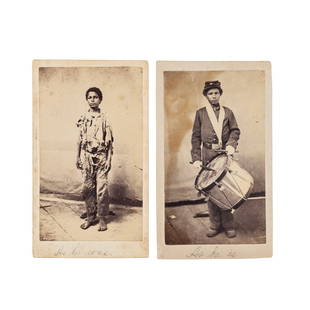
![[France-Belgium-Luxembourg, Maps] Carte Taride, 1904](https://p1.liveauctioneers.com/2198/56199/31008256_1_x.jpg?quality=1&version=1415833748&width=486)
![[France-Belgium-Luxembourg, Maps] Carte Taride, 1904](https://p1.liveauctioneers.com/2198/56199/31008256_1_x.jpg?quality=80&version=1415833748)
Item Details
Description
THREE POCKET MAPS, USED DURING THE FIRST WORLD WAR, 1914-1918
[1.]: A. Taride. Nouvelle carte de France à l'usage des cyclistes et automobilistes. D'apres la carte de l'Etat-Major, echelle du 1/250.000. Carte Taride n.° 1 - Nord de la France et Belgique. Paris: A. Taride Editeur, 18-2' Boulevard St Denis, 1904.
[together with]:
[2.]: A. Taride. Nouvelle carte de France à l'usage des cyclistes et automobilistes. D'apres la carte de l'Etat-Major, echelle du 1/250.000. Carte Taride n.° 2 - Nord-Est de la France. Paris: A. Taride Editeur, 18-2' Boulevard St Denis, 1904.
[together with]:
[3.]: A. Taride. Nouvelle carte de France à l'usage des cyclistes et automobilistes. D'apres la carte de l'Etat-Major, echelle du 1/250.000. Carte Taride n.° 6 - Est de la France - Section Nord. Paris: A. Taride Editeur, 18-2' Boulevard St Denis, 1904.
3 maps, engraved on zinc by Monrocq (imp. sur zinc, Monrocq, Paris), colored, folded as issued into a stiff card envelope folder; 700 x 900 mm on sheet, 640 x 865 mm on map, 185 x 130 mm folded. Scale: 1/250.000.
Three pocket maps of North France, Luxembourg and East Belgium, used during the First World War, 1914-1918.
At front side of the envelope folder there is the no. of the map and its cost, while at the rear side there is a table index of the Taride maps (Tableau d'assemblage de la Carte Taride), then some information regarding the cost of the available types of maps and few editorial advertisements.
On top right side of the map no. 1 there are some information regarding the Belgian contribution to the publication of the map itself (publiée sous la direction du Nord Touriste et de Monsieur Artiges, chef du service des excursions de la Ligue Velocipedique Belge).
Riferimenti:
[1.]: OCLC, 223437210 (3 copies in USA).
[2.]: OCLC, 40386875 (5 copies in USA).
[3.]: OCLC, 50996256 (3 copies in USA).
Condition
Traces of use and little stains at the folders; the envelope folder of the map [1.] is a bit worn; maps are in very good clean condition.
Buyer's Premium
- 15% up to €5,000.00
- 13% up to €10,000.00
- 10% above €10,000.00
[France-Belgium-Luxembourg, Maps] Carte Taride, 1904
Estimate €70 - €80
Get approved to bid.
Shipping & Pickup Options
Item located in Verona, itSee Policy for Shipping
Payment

Related Searches
TOP