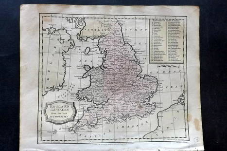
Ortelius map of England and Wales 1573
Abraham Ortelius Sale History
View Price Results for Abraham OrteliusRelated Maps & Atlases
More Items from Abraham Ortelius
View MoreRecommended Transportation & Travel Collectibles
View More


Item Details
Description
Heading:
Author: Ortelius, Abraham
Title: Angliae Regni Florentissimi Nova Descriptio, Auctore Humfredo Lhuyd Denbygiense
Place Published: Antwerp
Publisher:
Date Published: 1573-
Description:
Author: Ortelius, Abraham
Title: Angliae Regni Florentissimi Nova Descriptio, Auctore Humfredo Lhuyd Denbygiense
Place Published: Antwerp
Publisher:
Date Published: 1573-
Description:
Copper-engraved map, hand-colored (possibly later). 38x47 cm. (15x18½").
The first publication, by Abraham Ortelius, of the Welsh historian and topographer Humphrey Lluyd's important map of England and Wales, improving on the Mercator-Ortelius outline, and with notable decorative features. The map appeared in the first supplement to Ortelius' atlas in 1573, and in subsequent editions of the atlas perhaps as late as 1612. It is not known the exact date of issue of the present map. Karrow 50/3.1; Shirley 98 et seq., Plate 25.
Condition
Verso repair at lower central crease, mild soiling, very good, attractive.
Buyer's Premium
- 23%
Ortelius map of England and Wales 1573
Estimate $500 - $800
5 bidders are watching this item.
Shipping & Pickup Options
Item located in San Francisco, CA, usSee Policy for Shipping
Payment

TOP


![[MAP]. ORTELIUS, Abraham. Peregrinationis Divi Pauli Typus Corographicus. 1592.: [MAP]. ORTELIUS, Abraham (1527-1598). Peregrinationis Divi Pauli Typus Corographicus. Antwerp, 1592. Engraved map with hand-coloring. Matted, framed, and double glazed, visible area 381 x 533 mm (unex](https://p1.liveauctioneers.com/197/329395/177650535_1_x.jpg?height=310&quality=70&version=1715364962)
![[MAP]. ORTELIUS, Abraham. Romani Imperii Imago. 1592.: [MAP]. ORTELIUS, Abraham (1527-1598). Romani Imperii Imago. Antwerp, 1592. Engraved map with hand-coloring. Matted, framed, and double glazed, visible area 381 x 521 mm (unexamined out of frame). 6 de](https://p1.liveauctioneers.com/197/329395/177650537_1_x.jpg?height=310&quality=70&version=1715364962)
![[MAP]. ORTELIUS, Abraham. Presbiteri Iohannis, sive, Abissinorum Imperii Descriptio. 1592.: [MAP]. ORTELIUS, Abraham. (1527-1598). Presbiteri Iohannis, sive, Abissinorum Imperii Descriptio. Antwerp, 1592. Engraved map with hand-coloring. Matted, framed, and double glazed, visible area 406 x](https://p1.liveauctioneers.com/197/329395/177650536_1_x.jpg?height=310&quality=70&version=1715364962)
![[MAP]. ORTELIUS, Abraham. Turcici Imperii Descriptio.1592.: [MAP]. ORTELIUS, Abraham (1527-1598). Turcici Imperii Descriptio. Antwerp, 1592. Engraved map with hand-coloring. Matted, framed, and double glazed, sight 406 x 521 mm (unexamined out of frame). Decor](https://p1.liveauctioneers.com/197/329395/177650538_1_x.jpg?height=310&quality=70&version=1715364962)
![[MAP]. ORTELIUS, Abraham. Americae Sive Novi Orbis, Nova Descriptio. 1573.: [MAP]. ORTELIUS, Abraham (1527-1598). Americae Sive Novi Orbis, Nova Descriptio. Antwerp, 1573. Engraved map with hand-coloring. Framed and double glazed, visible area 375 x 521 mm (unexamined out of](https://p1.liveauctioneers.com/197/329395/177650534_1_x.jpg?height=310&quality=70&version=1715364962)
![[MAP]. ORTELIUS, Abraham. Aevi Veteris, Typus Geographicus. 1601.: [MAP]. ORTELIUS, Abraham (1527-1598). Aevi Veteris, Typus Geographicus. Antwerp, 1601. Engraved map with hand-coloring. Matted, framed, and double glazed, visible area 343 x 470 mm (unexamined out of](https://p1.liveauctioneers.com/197/329395/177650532_1_x.jpg?height=310&quality=70&version=1715364962)
![[MAP]. ORTELIUS, Abraham. Africae Tabula Nova. 1592.: [MAP]. ORTELIUS, Abraham (1527-1598). Africae Tabula Nova. Antwerp, 1592. Engraved map with hand-coloring. Matted, framed, and double glazed, visible area 406 x 533 mm (unexamined out of frame). Strap](https://p1.liveauctioneers.com/197/329395/177650533_1_x.jpg?height=310&quality=70&version=1715364962)
![[MAPS]. ORTELIUS, Abraham. A group of 3 engraved maps with hand-coloring.: [MAPS]. ORTELIUS, Abraham (1527-1598). A group of 3 engraved maps with hand-coloring, comprising: Gallia Vetus. Antwerp, 1592. Latin text on verso. Van den Broecke Ort194 (1592L5). -- Wirtenberg Ducat](https://p1.liveauctioneers.com/197/329395/177650539_1_x.jpg?height=310&quality=70&version=1715364962)


![A block puzzle with maps of Europe, England, Ireland, Scotland, America and the World: [BLOCK PUZZLE] Boxed set of 20 cubical blocks, each face with a portion of one of six hand-colored lithographed maps. Probably Irish: mid-nineteenth century. Blocks overall 7 5/8 x 6 1/4 inches (19.5](https://p1.liveauctioneers.com/292/330597/178279620_1_x.jpg?height=310&quality=70&version=1716409282)


![Ortelius: Ortelius Scotiae Tabula [Antwerp, c.1600] 37 x 48cm, hand-coloured, framed and glazed, some browning, a closed tear and a few small, neat repairs](https://p1.liveauctioneers.com/94/330664/178342463_1_x.jpg?height=310&quality=70&version=1716466933)


![[FLAGS]. 31-star American parade flag. Ca 1850-1859.: [FLAGS]. 31-star American parade flag. Ca 1850-1859. 22 x 36 1/2 in. cotton flag with 31 printed stars, configured in a double medallion surrounding a much larger central star, that is haloed in both](https://p1.liveauctioneers.com/197/329785/177758218_1_x.jpg?height=310&quality=70&version=1715625218)


