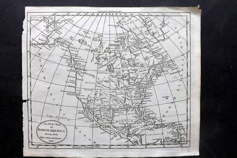
A NEW MAP OF NORTH AMERICA FROM 1763 DISCOVERIES
Similar Sale History
View More Items in Maps & AtlasesRelated Maps & Atlases
More Items in Maps & Atlases
View MoreRecommended Transportation & Travel Collectibles
View More


Item Details
Description
Printed on laid paper with Irish 1763 Pro Patria watermark of Detailed map of the British Colonies in North America at the close of the French & Indian War. The claims of the Carolinas, Virginia and New England extend eastward toward the Pacific Ocean. Georgia is now shown, as are many Indian Regions. The Earl of Granville's line is shown, as is the more southerly Florida/Carolina Boundary. 11 x 15 inches.
Condition
Good, (2) 1/2 inch tear to right edge.
Buyer's Premium
- 20%
A NEW MAP OF NORTH AMERICA FROM 1763 DISCOVERIES
Estimate $200 - $300
16 bidders are watching this item.
Shipping & Pickup Options
Item located in Amesbury, MA, usSee Policy for Shipping
Payment

Related Searches
TOP


![CARY, JOHN. A New Map of North America. [and] A New Map of America.: CARY, JOHN. A New Map of North America. [and] A New Map of America. Together two engraved maps of the western hemisphere. 22x25½ inches each sheet size, wide margins; nice original hand-color in](https://p1.liveauctioneers.com/199/251723/130782287_1_x.jpg?height=310&quality=70&version=1655133895)


![A desirable early issue of Hondius map of Virginia and Florida: [MAP-NORTH AMERICA] MERCATOR, GERARD and HONDIUS, JOCODUS. Virginiae item et Floridae Americae Provinciarum, nova descriptio. [Amsterdam: Jodocus Hondius, 1607 or later]. Hand-colored engraved map. Wi](https://p1.liveauctioneers.com/292/326828/175962855_1_x.jpg?height=310&quality=70&version=1713473479)
![A highly detailed map of New England after the Jansson-Visscher series: [MAP-NORTH AMERICA] [MONTANUS, ARNOLDUS]. Novi Belgii Quod nune Novi Jorck vocatur, Novae Angliae & Partis](https://p1.liveauctioneers.com/292/326828/175962858_1_x.jpg?height=310&quality=70&version=1713473479)
![Homann's expansive map of North America: [MAP-NORTH AMERICA] HOMANN, JOHANN BAPTISTA.Regni Mexicani seu Novae Hispaniae Ludov](https://p1.liveauctioneers.com/292/326828/175962859_1_x.jpg?height=310&quality=70&version=1713473479)
![Jansson's important early map of New England: [MAP-NORTH AMERICA] JANSSON, JAN. Nova Belgica et Anglia Nova. Amsterdam: circa 1646. Latin text on verso. Neat lines 15 1/4 x 19 3/4 inches (38.7 x 50.5 cm). Marginal tears r](https://p1.liveauctioneers.com/292/326828/175962856_1_x.jpg?height=310&quality=70&version=1713473479)
![After De L'Ise's map of North America: [MAP-NORTH AMERICA] DE L'ISLE, GUILLAUME, after. L'Amerique Septentrionale Dressee sur les Observations de Mrs de l'Academie Royale des Sciences. Amsterdam: R.& J. Ottens, circa 1730 or later. Han](https://p1.liveauctioneers.com/292/326828/175962860_1_x.jpg?height=310&quality=70&version=1713473479)
![A marked improvement on the Hondius map of 1606 (Burden): [MAP-NORTH AMERICA] [JANSSON, JAN]. Virginiae partis australis et Floridae partis orientalis, interjacentiumq, regionum Nova Descriptio. Amsterdam: Blaeu, circa 1640. Second state (left cherub with ta](https://p1.liveauctioneers.com/292/326828/175962857_1_x.jpg?height=310&quality=70&version=1713473479)
![The top sheet of the famous Ratzer Map - with additions relating to an 1810 real estate dispute: RATZER, BERNARD. Plan of the City of New York, in North America surveyed in the Years 1766 & 1767. [London: Jefferys & Faden, 12 January 1776.] Engraved map with hand coloring and manuscript a](https://p1.liveauctioneers.com/292/326828/175962862_1_x.jpg?height=310&quality=70&version=1713473479)


![Three maps of the United States: [MAPS - AMERICA] A Group of three maps of the United States, including [SHAFFNER TALIAFERRO PRESTON, ] United States. [London,1862]. Hand-colored lithographed folding map from The War in Am](https://p1.liveauctioneers.com/292/326828/175962868_1_x.jpg?height=310&quality=70&version=1713473479)


