
 Weekly: JewelryBonhamsSponsored.Your ad here?


 DesignChristie'sSponsored.Your ad here?


 DesignChristie'sSponsored.Your ad here?


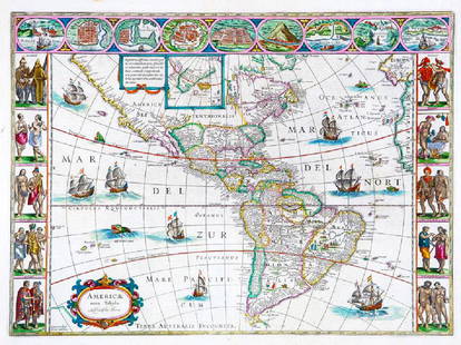
Ortelius' landmark map of Americas
Similar Sale History

Recommended Items


Item Details
Description
Author: Ortelius, Abraham
Title: Americae Sive Novi Orbis Nova Descriptio
Place Published:
Publisher:Antwerp
Date Published: 1579
Description:
Copper-engraved map, hand-colored (later). 36.5x51.5 cm. (14½x20¼").
Landmark map of the Americas, one of the most widely disseminated of its time, of great influence, the product of one of the leading mapmakers of his or any era. Burden calls it "One of the most famous and easily recognizable maps of America, and one that is both functional as well as decorative." Its great influence was due to a large extent to its presence in Ortelius' Theatrum Orbis Terrarum, the first atlas produced that uniformly covered the world with similarly sized and styled maps. Published on May 20, 1570, it was instantly successful, and went through four issues in the first year alone. Burden goes on to note that "Ortelius depicts the discoveries of a number of people on this map, but the general shape of the continent is derived from Gerard Mercator's great twenty-one sheet world map of the previous year... One of the main noticeable features of the map is the bulbous Chilean coastline; this was not corrected until his third plate [produced in 1587]. A strategically placed cartouche hides a complete lack of knowledge of the southern waters of the Pacific... The west coast of North America is shown too far west, as was common at the time..." There were three copper plates made over the life of the atlas for the American map. The present map is from the second plate, issued in 1579, quite similar to the 1570 first plate, but with the strapwork border 4 mm. thick, the largest ship in the Pacific sailing eastwards, and graduations along the equatorial line. Burden 39; Goss p.34.
Condition
Buyer's Premium
- 23%
Ortelius' landmark map of Americas
Shipping & Pickup Options
Item located in San Francisco, CA, usPayment


![Ortelius map of East Indies 1570: Heading: Author: Ortelius, Abraham Title: Indiae Orientalis Insularumque Adjacientium Typus Place Published: [Antwerp] Publisher: Date Published: 1570- Description: Copper-engra](https://p1.liveauctioneers.com/642/86438/44449716_1_x.jpg?height=310&quality=70&version=1458591928)


![[Abraham Ortelius]. Map: "SEPTENTRIONALIUM REGI: [Abraham Ortelius]. Map: "SEPTENTRIONALIUM REGIONUM DESCRIP." (Northern Region Described). <](https://p1.liveauctioneers.com/906/75482/39390114_1_x.jpg?height=310&quality=70&version=1437676383)


![[MAP]. ORTELIUS, Abraham. Africae Tabula Nova. 1592.: [MAP]. ORTELIUS, Abraham (1527-1598). Africae Tabula Nova. Antwerp, 1592. Engraved map with hand-coloring. Matted, framed, and double glazed, visible area 406 x 533 mm (unexamined out of frame). Strap](https://p1.liveauctioneers.com/197/329395/177650533_1_x.jpg?height=310&quality=70&version=1715364962)

![1581 Ortelius Map of Tuscany [with] Corsica [with] Ancona -- Senensis Ditionis, Accurata Descrip [on: Title: 1581 Ortelius Map of Tuscany [with] Corsica [with] Ancona -- Senensis Ditionis, Accurata Descrip [on sheet with] Corsica [and] Marcha Anconae, olim Picenum Cartographer: A Ortelius Year / Place](https://p1.liveauctioneers.com/5584/331064/178466435_1_x.jpg?height=310&quality=70&version=1716924723)

![[MAP]. ORTELIUS, Abraham. Romani Imperii Imago. 1592.: [MAP]. ORTELIUS, Abraham (1527-1598). Romani Imperii Imago. Antwerp, 1592. Engraved map with hand-coloring. Matted, framed, and double glazed, visible area 381 x 521 mm (unexamined out of frame). 6 de](https://p1.liveauctioneers.com/197/329395/177650537_1_x.jpg?height=310&quality=70&version=1715364962)
![[MAP]. ORTELIUS, Abraham. Peregrinationis Divi Pauli Typus Corographicus. 1592.: [MAP]. ORTELIUS, Abraham (1527-1598). Peregrinationis Divi Pauli Typus Corographicus. Antwerp, 1592. Engraved map with hand-coloring. Matted, framed, and double glazed, visible area 381 x 533 mm (unex](https://p1.liveauctioneers.com/197/329395/177650535_1_x.jpg?height=310&quality=70&version=1715364962)
![[MAP]. ORTELIUS, Abraham. Presbiteri Iohannis, sive, Abissinorum Imperii Descriptio. 1592.: [MAP]. ORTELIUS, Abraham. (1527-1598). Presbiteri Iohannis, sive, Abissinorum Imperii Descriptio. Antwerp, 1592. Engraved map with hand-coloring. Matted, framed, and double glazed, visible area 406 x](https://p1.liveauctioneers.com/197/329395/177650536_1_x.jpg?height=310&quality=70&version=1715364962)
![[MAP]. ORTELIUS, Abraham. Americae Sive Novi Orbis, Nova Descriptio. 1573.: [MAP]. ORTELIUS, Abraham (1527-1598). Americae Sive Novi Orbis, Nova Descriptio. Antwerp, 1573. Engraved map with hand-coloring. Framed and double glazed, visible area 375 x 521 mm (unexamined out of](https://p1.liveauctioneers.com/197/329395/177650534_1_x.jpg?height=310&quality=70&version=1715364962)
![[MAP]. ORTELIUS, Abraham. Turcici Imperii Descriptio.1592.: [MAP]. ORTELIUS, Abraham (1527-1598). Turcici Imperii Descriptio. Antwerp, 1592. Engraved map with hand-coloring. Matted, framed, and double glazed, sight 406 x 521 mm (unexamined out of frame). Decor](https://p1.liveauctioneers.com/197/329395/177650538_1_x.jpg?height=310&quality=70&version=1715364962)
![[MAP]. ORTELIUS, Abraham. Aevi Veteris, Typus Geographicus. 1601.: [MAP]. ORTELIUS, Abraham (1527-1598). Aevi Veteris, Typus Geographicus. Antwerp, 1601. Engraved map with hand-coloring. Matted, framed, and double glazed, visible area 343 x 470 mm (unexamined out of](https://p1.liveauctioneers.com/197/329395/177650532_1_x.jpg?height=310&quality=70&version=1715364962)
![[MAPS]. ORTELIUS, Abraham. A group of 3 engraved maps with hand-coloring.: [MAPS]. ORTELIUS, Abraham (1527-1598). A group of 3 engraved maps with hand-coloring, comprising: Gallia Vetus. Antwerp, 1592. Latin text on verso. Van den Broecke Ort194 (1592L5). -- Wirtenberg Ducat](https://p1.liveauctioneers.com/197/329395/177650539_1_x.jpg?height=310&quality=70&version=1715364962)


![British Plantation Map of the Americas [179303]: This is a circa 1770s map by chart engraver Thomas Bowen of London, showing the British American plantations from Boston down to the Carolinas. As with most all maps in the 16th, 17th and 18th century](https://p1.liveauctioneers.com/2699/331495/178785748_1_x.jpg?height=310&quality=70&version=1717094933)

