Civil War Era Map of Charleston, SC and Environs
Similar Sale History
View More Items in Militaria & War MemorabiliaRelated Militaria & War Memorabilia
More Items in Militaria & War Memorabilia
View MoreRecommended Collectibles
View More


Item Details
Description
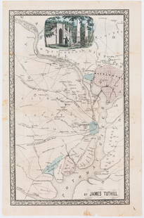
E & G. W. Blunt's Map of Charleston and Vicinity (New York: E & G. W. Blunt, 1862), a handy map for military purposes showing both land and sea routes in the region. Unframed in a 1950s mailing/storage tube.
21 x 23.75 in.
Per an attached note, this map was an early 1950s gift from Mrs. Charles A. Cannon of Cannon MiIlls.
Margaret Fisher McIver Estate, Carrboro, NC.
Additional high-resolution photos are available at LelandLittle.com
21 x 23.75 in.
Per an attached note, this map was an early 1950s gift from Mrs. Charles A. Cannon of Cannon MiIlls.
Margaret Fisher McIver Estate, Carrboro, NC.
Additional high-resolution photos are available at LelandLittle.com
Condition
Overall age toning; some foxing; splits.
Buyer's Premium
- 23%
Civil War Era Map of Charleston, SC and Environs
Estimate $50 - $50,000
6 bidders are watching this item.
Shipping & Pickup Options
Item located in Hillsborough, NC, usSee Policy for Shipping
Payment

Related Searches
TOP


![Rare Antique Civil War Era Circular of Kingsbury, Tennessee, 1864: Antique Civil War Era Circular refuting certain tax computations and assessments, and addressed TO THE ELECTORS OF THE TOWN OF KINGSBURY. [TENNESSEE]. Dated November 5, 1864. Matted and framed under g](https://p1.liveauctioneers.com/6084/327145/176275200_1_x.jpg?height=310&quality=70&version=1714406766)


![George Washington Signed Discharge: Partly printed discharge document signed by George Washington, as Commander in Chief of the Armies of the United States. Newburgh, [New York], 4 January 1783. 1 page, ## x ## in. Undersigned by Washin](https://p1.liveauctioneers.com/7226/322253/173251475_1_x.jpg?height=310&quality=70&version=1710004847)
![[Ambrotype] Texas Confederate Soldier: Sixth plate ambrotype. Full leatherette case. Portrait of a possible Texas Confederate soldier. A silver star device was used to pin up the brim of his light-toned headgear, a look often seen in image](https://p1.liveauctioneers.com/7226/322253/173251509_1_x.jpg?height=310&quality=70&version=1710004847)

![Captured Bowie Knife w/ Period Note of Provenance: Captured Confederate D-hilt Bowie knife. [Kenansville, North Carolina]: [Louis Froelich factory]. With original metal and leather sheath with affixed period notes. First note with only remnants. Secon](https://p1.liveauctioneers.com/7226/325455/175169154_1_x.jpg?height=310&quality=70&version=1712370394)
![[Civil War] Bullet Which Nearly Killed Soldier: Lead bullet encased in gold acorn fob with chain. Finely engraved: "W.D. Fiske / 14th Regt. C V / Fredericksburg / Dec 17, 1863." Acorn approx. 1 1/2 x 1 in. Overall length 6 1/2 in. Published in "Her](https://p1.liveauctioneers.com/7226/325455/175169103_1_x.jpg?height=310&quality=70&version=1712370394)
![[CIVIL WAR] 1st Texas Infantry in Camp: Outdoor half plate ambrotype of the 1st Texas Infantry. Full leatherette case. Significant, large half plate ambrotype of members of the 1st Texas Infantry at ‘Splinterville,’ the regiment’s win](https://p1.liveauctioneers.com/7226/322253/173251512_1_x.jpg?height=310&quality=70&version=1710004847)
![[HANCOCK, John] Washington’s Spy, Officer’s Commission: Partly printed document signed by John Hancock as President of the Continental Congress, for Epaphras Bull (1748-1781). [Philadelphia, Pennsylvania], 10 January 1777. 1 page, ## x ## in. Completed in](https://p1.liveauctioneers.com/7226/322253/173251471_1_x.jpg?height=310&quality=70&version=1710004847)
![[CIVIL WAR] Black Soldier & Wife: CDV-sized tintype photograph WITH gem-sized tintype. Full thermoplastic case. Portrait of an unknown African American Civil War soldier who holds the rank of sergeant. He looks directly at the camera](https://p1.liveauctioneers.com/7226/322253/173251671_1_x.jpg?height=310&quality=70&version=1710004847)
![Historic Einstein Signed Program from Lincoln University Visit: Conferences on Objectives. Lincoln University, [Oxford], Pennsylvania, 3 May 1946. SIGNED BY ALBERT EINSTEIN. Tipped into Horace Mann Bond (1904-1972). The Education of the Negro in the American Socia](https://p1.liveauctioneers.com/7226/322253/173251693_1_x.jpg?height=310&quality=70&version=1710004847)

![[CIVIL WAR] Captured Confederate Canteen: Wooden drum canteen with iron hardware. "C.S.A." painted in white ink/paint to side. Period ink inscribed label affixed to side reading in full: "Confederate Canteen Captured from a Confederate soldie](https://p1.liveauctioneers.com/7226/325455/175169142_1_x.jpg?height=310&quality=70&version=1712370394)


