


Merian: Tabula Portuum Barbariae (Barbary Coast), 1638
Similar Sale History
View More Items in Maps & Atlases


![17th century map of Russia by Merian: Heading: Author: Merian, Matthaus, the elder Title: Tabula Russiae... alias dicta Moscovia Place Published: Frankfurt Publisher: Date Published: [c.1645] Description: Copper-eng](https://p1.liveauctioneers.com/642/86438/44449706_1_x.jpg?height=310&quality=70&version=1458591928)


Related Maps & Atlases
![Homann's expansive map of North America: [MAP-NORTH AMERICA] HOMANN, JOHANN BAPTISTA.Regni Mexicani seu Novae Hispaniae Ludov](https://p1.liveauctioneers.com/292/326828/175962859_1_x.jpg?height=310&quality=70&version=1713473479)


![[Maps] Martin Zeiler, Itinerarium Italiae, 1640: [Maps] Martin Zeiler, Itinerarium Italiae, 1640, Martini Zeilleri. Itinerarium Italiae Nov-Antiquae: oder, Raiss-Beschreibung durch Italien, Matthaus Merian, Frankfurt, 40 plates, most double-page, in](https://p1.liveauctioneers.com/188/326797/176317459_1_x.jpg?height=310&quality=70&version=1713847031)


More Items in Maps & Atlases
View More


Recommended Transportation & Travel Collectibles
View More


Item Details
Description
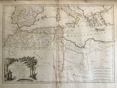
Merian's scarce and detailed chart of the west coasts of Iberia and Morocco (Barbary) and the Canary Islands, Madeira and the Azores. The chart inludes many place names along the continental coasts and features a coat of arms, compass rose, and two cartouches, with a turbaned figure atop the mileage scale cartouche.
Please note that this lot has a confidential reserve. When you leave a bid in advance of the auction, submit your maximum. Jasper52 will bid on your behalf as much as necessary to ensure that you meet the reserve price or that you remain in the lead, up to your maximum. The bidder who has submitted the highest bid wins the lot, provided the bid exceeds the reserve price.
Shipping:
Authenticity:
Photos, descriptions, and estimates were prepared with the utmost care by a fully certified expert and appraiser. All items in this sale are guaranteed authentic. Please contact us if there is a misrepresentation so that the item can be returned.
Your purchase is protected:
In the rare event that your purchase from this auction does not meet your expectations, Jasper52 specialists are here to help. If the item did not conform to the lot description in the sale, U.S. buyers may return the item for a full refund provided you notify Jasper52 within 5 days of receiving the item.
Condition
b&w; tear in lower margin repaired; cleaned and backed
Buyer's Premium
- 10%
Merian: Tabula Portuum Barbariae (Barbary Coast), 1638
Estimate $100 - $150
1 bidder is watching this item.
Shipping & Pickup Options
Item located in New York, USSee Policy for Shipping
Payment
See More Items From This Jasper52 Seller

Related Searches
TOP