


James Carter MAP OF NEW HAMPSHIRE Portsmouth March 1831
James Carter Sale History
View Price Results for James Carter


Recommended Items


Item Details
Description
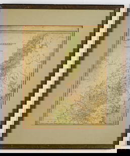
Details: CARTER, James G. (1795-1849). A Map of New Hampshire. Portsmouth: Nathaniel March, [1831]. Engraved folding pocket map, full period hand colouring. Statistical table at right side. Folds into publisher's straight grained morocco, title in gilt on the upper cover, rebacked. Sheet size: 17 x 11 inches.
Scarce pocket map of New Hampshire.
This colourful map of the state was separately published by Carter to accompany his Geography of New Hampshire (Portsmouth and Boston, 1831). Carter was an early advocate of public education and would be among the first reformers to establish a state board of education.
Not in Phillips, A List of Maps of America.
Condition / Notes:
For lots which include only books, our shipping charge applies to any address within the fifty United States. For lots which are not books, the stated shipping cost in this listing will apply only to addresses within the continental 48 states. Within those parameters, the shipping cost for this lot will be: $16.50
Buyer's Premium
- 25%
James Carter MAP OF NEW HAMPSHIRE Portsmouth March 1831
Estimate $300 - $500
1 bidder is watching this item.
Shipping & Pickup Options
Item located in Freeville, NY, usSee Policy for Shipping
Payment

Related Searches
TOP