


Tanner: Antique Map of Asia, 1828
Similar Sale History
View More Items in Maps & Atlases


Related Maps & Atlases


More Items in Asian Maps & Atlases
View More


Recommended Transportation & Travel Collectibles
View More


![[FLAGS]. 31-star American parade flag. Ca 1850-1859.: [FLAGS]. 31-star American parade flag. Ca 1850-1859. 22 x 36 1/2 in. cotton flag with 31 printed stars, configured in a double medallion surrounding a much larger central star, that is haloed in both](https://p1.liveauctioneers.com/197/329785/177758218_1_x.jpg?height=310&quality=70&version=1715625218)


Item Details
Description
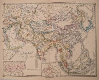
A striking, grand map of Asia plus New Holland (Australia), with the expect level of topographical, settlement details color-coded countries and other detail, including the Chinese Wall. From Tanner's American Atlas.
Henry S. Tanner was one of America’s most distinguished map engravers during the first half of the 19th century. He had engraved many notable maps for cartographers Aaron Arrowsmith, Samuel Lewis and John Melish before producing his own. In his Geographical Memoir, Tanner claimed he had devoted nearly ten years of his life to his monumental map of North America. This "Map of North America" would serve as a foundation or master map for the next generation of significant maps of the American West.
Shipping:
Your purchase is protected:
Photos, descriptions, and estimates were prepared with the utmost care by a fully certified expert and appraiser. All items in this sale are guaranteed authentic.
In the rare event that the item did not conform to the lot description in the sale, Jasper52 specialists are here to help. Buyers may return the item for a full refund provided you notify Jasper52 within 5 days of receiving the item.
Condition
Excellent. Sharp strike and well colored. Just a slight hint of age toning. Issued centerfold and generous margins.
Buyer's Premium
- 10%
Tanner: Antique Map of Asia, 1828
Estimate $400 - $450
3 bidders are watching this item.
Get approved to bid.
Shipping & Pickup Options
Item located in Ohio, USSee Policy for Shipping
Payment
See More Items From This Jasper52 Seller

Auction Curated By

Maps Expert
TOP