


Mitchell: County Map of Iowa and Missouri
Similar Sale History
View More Items in Maps & Atlases
![1869 Mitchell Map of US Midwest -- XIV Ohio, Kentucky, Indiana, Illinois, Iowa and Missouri [verso]: Title: 1869 Mitchell Map of US Midwest -- XIV Ohio, Kentucky, Indiana, Illinois, Iowa and Missouri [verso] XV Michigan and Wisconsin Cartographer: S Mithchell Year / Place: 1869, Philadelphia Map Dime](https://p1.liveauctioneers.com/5584/305309/163064973_1_x.jpg?height=310&quality=70&version=1697577828)

![Large Map of Illinois Iowa & Missouri: Map of Illinois With map of Iowa and Missouri [separately] on versos Cartographer: George Franklin Cram Dated: Circa 1900 Type: Color Lithograph](https://p1.liveauctioneers.com/5614/294993/156626705_1_x.jpg?height=310&quality=70&version=1688581746)


Related Maps & Atlases


More Items in Maps & Atlases
View More


Recommended Transportation & Travel Collectibles
View More


Item Details
Description
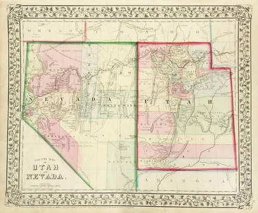
The beautifully detailed and colored county map of the states of Iowa and Missouri from the 1870 edition of Mitchell's popular New General Atlas of the world. Framed by the decorative vine motif border typical of Mitchell maps of the mid-1860s to 1881, the map encompasses parts of Illinois, Nebraska, Kansas, and a corner of "Indian Territory," the future state of Oklahoma.
Please note that this lot has a confidential reserve. When you leave a bid in advance of the auction, submit your maximum. The bidder who has submitted the highest bid wins the lot, provided the bid exceeds the reserve price.
Shipping:
Your purchase is protected:
Photos, descriptions, and estimates were prepared with the utmost care by a fully certified expert and appraiser. All items in this sale are guaranteed authentic.
In the rare event that the item did not conform to the lot description in the sale, Jasper52 specialists are here to help. Buyers may return the item for a full refund provided you notify Jasper52 within 5 days of receiving the item.
Condition
full color; light overall age toning
Buyer's Premium
- 15%
Mitchell: County Map of Iowa and Missouri
Estimate $40 - $50
1 bidder is watching this item.
Shipping & Pickup Options
Item located in New York, USSee Policy for Shipping
Payment
Accepts seamless payments through LiveAuctioneers
See More Items From This Jasper52 Seller

Related Searches
TOP