MAP - Eastern Ireland. Mercator/Hondius
Similar Sale History
View More Items in Maps & AtlasesRelated Maps & Atlases
More Items in Maps & Atlases
View MoreRecommended Transportation & Travel Collectibles
View More


Item Details
Description
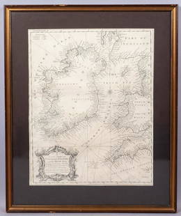
Eastern Ireland. Mercator/Hondius, Udrone, 1610 (published). Hand Color. Laghlyn is near the center of this small map. It is an excellent early portrayal of the Carlow region in Leinster province, showing cities, towns, rivers and mountains. The title and distance scales are included in the strapwork cartouche. Latin text on verso.
LITERATURE: Van der Krogt (Vol. III) #5915:351.
LITERATURE: Van der Krogt (Vol. III) #5915:351.
Condition
A dark impression with light toning along the edges of the sheet. The alternate title and page number are printed within the image at top. Grade: A
Dimensions
5.4 x 7 in
Buyer's Premium
- 20%
MAP - Eastern Ireland. Mercator/Hondius
Estimate $120 - $150
2 bidders are watching this item.
Get approved to bid.
Shipping & Pickup Options
Item located in Glen Allen, VA, usSee Policy for Shipping
Payment
Accepts seamless payments through LiveAuctioneers

Related Searches
TOP


![MAP, Eastern Canada, Direccion de Hidrografia: Newfoundland & Labrador. Direccion de Hidrografia, [On 2 Sheets] Carta Esferica en dos Hojas del Banco y la Isla de Terranova con Parte de la Costa de Labrador..., 1840 (dated). Black & White. A highl](https://p1.liveauctioneers.com/6576/263260/137251069_1_x.jpg?height=310&quality=70&version=1664399834)


![1593 de Jode Maps of Eastern Germany (Saxony Area) and Western Germany -- Mansfeldiae Comitatus ...: Title: 1593 de Jode Maps of Eastern Germany (Saxony Area) and Western Germany -- Mansfeldiae Comitatus ... [on sheet with] Clivensis et Iuliacensis Ducatum Cartographer: G De Jode Year / Place: 1593,](https://p1.liveauctioneers.com/5584/330117/177981830_1_x.jpg?height=310&quality=70&version=1716324705)


![A block puzzle with maps of Europe, England, Ireland, Scotland, America and the World: [BLOCK PUZZLE] Boxed set of 20 cubical blocks, each face with a portion of one of six hand-colored lithographed maps. Probably Irish: mid-nineteenth century. Blocks overall 7 5/8 x 6 1/4 inches (19.5](https://p1.liveauctioneers.com/292/330597/178279620_1_x.jpg?height=310&quality=70&version=1716409282)


![Large Map of Texas (Eastern Part): Large Map of Texas (Eastern Part) With map of Alabama and Mississippi [separately] on versos Cartographer: George Franklin Cram Dated: Circa 1900 Type: Color Lithograph Dim](https://p1.liveauctioneers.com/5614/330257/178045312_1_x.jpg?height=310&quality=70&version=1716032806)


![[MAP]. TODESCHI, Pietro. [Nova et Acurata Totius Americae Tabula auct. G.I. Blaeu] America quarta: [MAP]. TODESCHI, Pietro. [Nova et Acurata Totius Americae Tabula auct. G.I. Blaeu] America quarta pars orbis quam plerunq, nuvum orbem appellitant primo detecta est anno 1492 a Christophoro Columbo...](https://p1.liveauctioneers.com/197/329395/177650542_1_x.jpg?height=310&quality=70&version=1715364962)


![[MAP]. ORTELIUS, Abraham. Americae Sive Novi Orbis, Nova Descriptio. 1573.: [MAP]. ORTELIUS, Abraham (1527-1598). Americae Sive Novi Orbis, Nova Descriptio. Antwerp, 1573. Engraved map with hand-coloring. Framed and double glazed, visible area 375 x 521 mm (unexamined out of](https://p1.liveauctioneers.com/197/329395/177650534_1_x.jpg?height=310&quality=70&version=1715364962)
![[MAPS]. HOMANN, Johann Baptist, HOMANN HEIRS, and Georg Matthäus SEUTTER. [Composite Atlas].: [MAPS]. HOMANN, Johann Baptist (1663-1724), HOMANN HEIRS, and Georg Matthäus SEUTTER (1678-1757). [Composite Atlas]. [Nuremberg, Augsburg, and others: Homann Heirs and others, maps dated between](https://p1.liveauctioneers.com/197/329395/177650530_1_x.jpg?height=310&quality=70&version=1715364962)


![[MAP]. ORTELIUS, Abraham. Turcici Imperii Descriptio.1592.: [MAP]. ORTELIUS, Abraham (1527-1598). Turcici Imperii Descriptio. Antwerp, 1592. Engraved map with hand-coloring. Matted, framed, and double glazed, sight 406 x 521 mm (unexamined out of frame). Decor](https://p1.liveauctioneers.com/197/329395/177650538_1_x.jpg?height=310&quality=70&version=1715364962)

![[MAP]. ORTELIUS, Abraham. Aevi Veteris, Typus Geographicus. 1601.: [MAP]. ORTELIUS, Abraham (1527-1598). Aevi Veteris, Typus Geographicus. Antwerp, 1601. Engraved map with hand-coloring. Matted, framed, and double glazed, visible area 343 x 470 mm (unexamined out of](https://p1.liveauctioneers.com/197/329395/177650532_1_x.jpg?height=310&quality=70&version=1715364962)


![[FLAGS]. 31-star American parade flag. Ca 1850-1859.: [FLAGS]. 31-star American parade flag. Ca 1850-1859. 22 x 36 1/2 in. cotton flag with 31 printed stars, configured in a double medallion surrounding a much larger central star, that is haloed in both](https://p1.liveauctioneers.com/197/329785/177758218_1_x.jpg?height=310&quality=70&version=1715625218)


