


1868 Dussieux World Map Routes of Explorers and Human
Similar Sale History
View More Items in Maps & Atlases


Related Maps & Atlases


More Items in Maps & Atlases
View More


![[Maps] Gio. Ant. Magnini, Italia, 1620: [Maps] Gio. Ant. Magnini, Italia, 1620, Giovanni Antonio Magnini. Italia, data in luce da Fabio suo figliuolo al Serenissimo Ferdinado Gonzaga Duca di Matoua edi Monserrato etc. Bologna, for Sebastian](https://p1.liveauctioneers.com/188/326797/176317457_1_x.jpg?height=310&quality=70&version=1713847031)

![[Maps] Martin Zeiler, Itinerarium Italiae, 1640: [Maps] Martin Zeiler, Itinerarium Italiae, 1640, Martini Zeilleri. Itinerarium Italiae Nov-Antiquae: oder, Raiss-Beschreibung durch Italien, Matthaus Merian, Frankfurt, 40 plates, most double-page, in](https://p1.liveauctioneers.com/188/326797/176317459_1_x.jpg?height=310&quality=70&version=1713847031)


Recommended Transportation & Travel Collectibles
View More


Item Details
Description
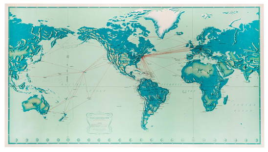
This is a very interesting world map showing the range of human races globally with the major groupings color-coded, and regions occupied by Europeans by the mid 1800's in blue. Also shown are the routes of key explorers over time and early discoveries of foreign lands by Europeans, with the name of the explorer and date shown. The extensive table on the right lists dated discoveries by Europeans from 6th century B.C. to 1863. From Atlas General de Geographie Physique, Politique et Historique.
Reserve: $80.00
Shipping:
Your purchase is protected:
Photos, descriptions, and estimates were prepared with the utmost care by a fully certified expert and appraiser. All items in this sale are guaranteed authentic.
In the rare event that the item did not conform to the lot description in the sale, Jasper52 specialists are here to help. Buyers may return the item for a full refund provided you notify Jasper52 within 5 days of receiving the item.
Condition
Very good. Slight toning. Nicely colored. Issued centerfold.
Buyer's Premium
- 15%
1868 Dussieux World Map Routes of Explorers and Human
Estimate $100 - $120
2 bidders are watching this item.
Shipping & Pickup Options
Item located in Ohio, US$12 shipping in the US
Payment
See More Items From This Jasper52 Seller

Auction Curated By

Maps Expert
Related Searches
TOP