


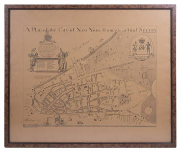
Major Holland A Plan of the City of New York 1776
Similar Sale History
View More Items in Maps & Atlases


![(3pc) MAPS OF NEW YORK: JOHN MONTRESOR: Including; "A Plan of the City of New York & Its Environs to Greenwich", for D.T. Valentine's Manual 1855; Bernard Ratzer,[29-3/4 x 23-3/4 in, framed]; "Plan of the City of New York in North America S](https://p1.liveauctioneers.com/522/173495/87372920_1_x.jpg?height=310&quality=70&version=1594330064)


![[MAP-CUBA] Official Map of Cuba. Folding lithographic map of Cuba published in Trumbull White's: [MAP-CUBA] Official Map of Cuba. Folding lithographic map of Cuba published in Trumbull White's Pictorial History of Our War With Spain, 1898. An inset features the city plan of Havana and text headed](https://p1.liveauctioneers.com/292/250642/130213661_1_x.jpg?height=310&quality=70&version=1654271664)
Related Maps & Atlases

![[NEW YORK CITY – PICTORIAL MAPS]. Group of 3 pictorial maps...: [NEW YORK CITY – PICTORIAL MAPS]. Group of 3 pictorial maps. Including: ANNAND, George (1890—1980). Sinclair Pictorial Map of New York/New York World’s Fair. 26 ¾ x 27 5/8”](https://p1.liveauctioneers.com/928/325952/175495562_1_x.jpg?height=310&quality=70&version=1712935174)


More Items in Maps & Atlases
View More
![[Maps] Gio. Ant. Magnini, Italia, 1620: [Maps] Gio. Ant. Magnini, Italia, 1620, Giovanni Antonio Magnini. Italia, data in luce da Fabio suo figliuolo al Serenissimo Ferdinado Gonzaga Duca di Matoua edi Monserrato etc. Bologna, for Sebastian](https://p1.liveauctioneers.com/188/326797/176317457_1_x.jpg?height=310&quality=70&version=1713847031)
![[Maps] Martin Zeiler, Itinerarium Italiae, 1640: [Maps] Martin Zeiler, Itinerarium Italiae, 1640, Martini Zeilleri. Itinerarium Italiae Nov-Antiquae: oder, Raiss-Beschreibung durch Italien, Matthaus Merian, Frankfurt, 40 plates, most double-page, in](https://p1.liveauctioneers.com/188/326797/176317459_1_x.jpg?height=310&quality=70&version=1713847031)


![[MAP]. TODESCHI, Pietro. [Nova et Acurata Totius Americae Tabula auct. G.I. Blaeu] America quarta: [MAP]. TODESCHI, Pietro. [Nova et Acurata Totius Americae Tabula auct. G.I. Blaeu] America quarta pars orbis quam plerunq, nuvum orbem appellitant primo detecta est anno 1492 a Christophoro Columbo...](https://p1.liveauctioneers.com/197/329395/177650542_1_x.jpg?height=310&quality=70&version=1715364962)


Recommended Transportation & Travel Collectibles
View More


Item Details
Description
Major Holland, "A Plan of the City of New York," engraved map from the 1863 version by G. Hayward. The map was originally from 1776 and is considered one of the earliest and most iconic maps of Lower Manhattan.
Note: The image of the map appears yellow in the listing, but it is actually white; the map was framed under a yellowed piece of plastic.
Note: The image of the map appears yellow in the listing, but it is actually white; the map was framed under a yellowed piece of plastic.
SKU: 03581
Condition
Good condition, margins are trimmed, 2 inch tear along the top, and areas of adhesive residue along the margins.
Buyer's Premium
- 28%
Major Holland A Plan of the City of New York 1776
Estimate $200 - $300
11 bidders are watching this item.
Shipping & Pickup Options
Item located in St. Paul, MN, usSee Policy for Shipping
Payment

TOP