


1892 Cowles Civil War Map of Battles in Southeastern
Similar Sale History
View More Items in Militaria & War Memorabilia![1892 Cowles Civil War Map of Battles in Southeastern: Title: 1892 Cowles Civil War Map of Battles in Southeastern Virginia -- Military Department of Southeastern Virginia and Fort Monroe, 1861 [Plate XVI] Date: 1892, Washington Cartographer: C Cowles (co](https://p1.liveauctioneers.com/5584/159675/80583510_1_x.jpg?height=310&quality=70&version=1579644740)
![1894 Cowles Civil War Map of North Carolina and: Title: 1894 Cowles Civil War Map of North Carolina and Southern Virginia -- General Topographical Map, Sheet III [Plate CXXXVIII] Cartographer: C Cowles (compiled by) Year / Place: 1894, Washington Ma](https://p1.liveauctioneers.com/5584/230022/119005423_1_x.jpg?height=310&quality=70&version=1639520429)


Related Militaria & War Memorabilia


![[PRANG, Louis (1824-1909), printer and lithographer]. Group...: [PRANG, Louis (1824-1909), printer and lithographer]. Group of 5 Color Lithographs of Civil War Battles. [Boston: Prang and American Lithographic Co., 1887]. Color lithographs on paper from a later ed](https://p1.liveauctioneers.com/928/328184/176813684_1_x.jpg?height=310&quality=70&version=1714496988)

![[CIVIL WAR] Bullet-Struck Letter, Battle of Fredericksburg: We advanced into a cornfield...some along the lines were hit by bullets & some by grape & shells...It was then probably that my knapsack got its wound. Autograph letter signed by John P. Garrett, Co.](https://p1.liveauctioneers.com/7226/325455/175169098_1_x.jpg?height=310&quality=70&version=1712370394)
![[Gettysburg] The Horrors of War: The Horrors of War. Albumen photograph. Printed title to mount recto with caption. An image taken by photographer James F. Gibson (d. 1905) in the immediate aftermath of the Battle of Gettysburg. Prin](https://p1.liveauctioneers.com/7226/325455/175169090_1_x.jpg?height=310&quality=70&version=1712370394)

![[CIVIL WAR] Jennie Wade Souvenir Badge: Jennie Wade souvenir celluloid badge and ribbon. Pinback medallion with composite image of Jennie Wade, her house, and memorial & grave with the legend "Jennie Wade * House Where She Was Killed." Stam](https://p1.liveauctioneers.com/7226/325455/175169087_1_x.jpg?height=310&quality=70&version=1712370394)

![[CIVIL WAR] Pennsylvania Governor Curtin, Signed CDV: Vignetted albumen CDV portrait of Pennsylvania Governor Andrew Gregg Curtin. Philadelphia: A. Winch, n.d. Photographer's imprint to vero alongside pencil inscription reading "Gov Curtin." SIGNED BY CU](https://p1.liveauctioneers.com/7226/325455/175169065_1_x.jpg?height=310&quality=70&version=1712370394)
![Group of 6 Assorted Chromolithographs Plus Three Black and ...: Group of 6 Assorted Chromolithographs Plus Three Black and White Lithographs. [V.p., ca. 1880s-1930s]. Sizes range from approximately 5 ½ x 8” to 22 ½ x 28 ¼”. Some general](https://p1.liveauctioneers.com/928/328184/176813655_1_x.jpg?height=310&quality=70&version=1714496988)
![[PRANG, Louis (1824-1909), printer and lithographer]. Chrom...: [PRANG, Louis (1824-1909), printer and lithographer]. Chromolithograph Memorial of Ulysses S. Grant. [Boston: L. Prang & Co., ca. 1885]. Large chromolithograph with central portrait of Grant in unifor](https://p1.liveauctioneers.com/928/328184/176813685_1_x.jpg?height=310&quality=70&version=1714496988)

More Items in Militaria & War Memorabilia
View More


![George Washington Signed Discharge: Partly printed discharge document signed by George Washington, as Commander in Chief of the Armies of the United States. Newburgh, [New York], 4 January 1783. 1 page, ## x ## in. Undersigned by Washin](https://p1.liveauctioneers.com/7226/322253/173251475_1_x.jpg?height=310&quality=70&version=1710004847)
![[Ambrotype] Texas Confederate Soldier: Sixth plate ambrotype. Full leatherette case. Portrait of a possible Texas Confederate soldier. A silver star device was used to pin up the brim of his light-toned headgear, a look often seen in image](https://p1.liveauctioneers.com/7226/322253/173251509_1_x.jpg?height=310&quality=70&version=1710004847)
![Captured Bowie Knife w/ Period Note of Provenance: Captured Confederate D-hilt Bowie knife. [Kenansville, North Carolina]: [Louis Froelich factory]. With original metal and leather sheath with affixed period notes. First note with only remnants. Secon](https://p1.liveauctioneers.com/7226/325455/175169154_1_x.jpg?height=310&quality=70&version=1712370394)

![[Civil War] Bullet Which Nearly Killed Soldier: Lead bullet encased in gold acorn fob with chain. Finely engraved: "W.D. Fiske / 14th Regt. C V / Fredericksburg / Dec 17, 1863." Acorn approx. 1 1/2 x 1 in. Overall length 6 1/2 in. Published in "Her](https://p1.liveauctioneers.com/7226/325455/175169103_1_x.jpg?height=310&quality=70&version=1712370394)
![[CIVIL WAR] 1st Texas Infantry in Camp: Outdoor half plate ambrotype of the 1st Texas Infantry. Full leatherette case. Significant, large half plate ambrotype of members of the 1st Texas Infantry at ‘Splinterville,’ the regiment’s win](https://p1.liveauctioneers.com/7226/322253/173251512_1_x.jpg?height=310&quality=70&version=1710004847)
![[HANCOCK, John] Washington’s Spy, Officer’s Commission: Partly printed document signed by John Hancock as President of the Continental Congress, for Epaphras Bull (1748-1781). [Philadelphia, Pennsylvania], 10 January 1777. 1 page, ## x ## in. Completed in](https://p1.liveauctioneers.com/7226/322253/173251471_1_x.jpg?height=310&quality=70&version=1710004847)
![[CIVIL WAR] Black Soldier & Wife: CDV-sized tintype photograph WITH gem-sized tintype. Full thermoplastic case. Portrait of an unknown African American Civil War soldier who holds the rank of sergeant. He looks directly at the camera](https://p1.liveauctioneers.com/7226/322253/173251671_1_x.jpg?height=310&quality=70&version=1710004847)
![Historic Einstein Signed Program from Lincoln University Visit: Conferences on Objectives. Lincoln University, [Oxford], Pennsylvania, 3 May 1946. SIGNED BY ALBERT EINSTEIN. Tipped into Horace Mann Bond (1904-1972). The Education of the Negro in the American Socia](https://p1.liveauctioneers.com/7226/322253/173251693_1_x.jpg?height=310&quality=70&version=1710004847)

![[CIVIL WAR] Captured Confederate Canteen: Wooden drum canteen with iron hardware. "C.S.A." painted in white ink/paint to side. Period ink inscribed label affixed to side reading in full: "Confederate Canteen Captured from a Confederate soldie](https://p1.liveauctioneers.com/7226/325455/175169142_1_x.jpg?height=310&quality=70&version=1712370394)
Recommended Collectibles
View More


Item Details
Description
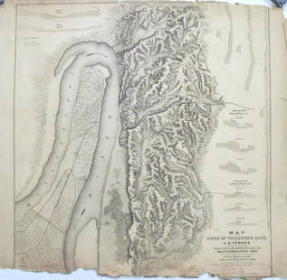
This is a highly detailed map showing Union and Confederate troop movements, color-coded, as of 1862. The two maps cover Yorktown to Hampton Roads. Lots of topographical, river, lake, railroad, road, settlement, etc detail is offered. Litho by J Bien & Co. From the Atlas to Accompany the Official Records of the Union and Confederate Armies.
Reserve: $50.00
Shipping:
Your purchase is protected:
Photos, descriptions, and estimates were prepared with the utmost care by a fully certified expert and appraiser. All items in this sale are guaranteed authentic.
In the rare event that the item did not conform to the lot description in the sale, Jasper52 specialists are here to help. Buyers may return the item for a full refund provided you notify Jasper52 within 5 days of receiving the item.
Condition
Good. Slight toning - more in margins. Marginal chips and splits. Issued centerfold. Colored.
Buyer's Premium
- 15%
1892 Cowles Civil War Map of Battles in Southeastern
Estimate $60 - $70
1 bidder is watching this item.
Shipping & Pickup Options
Item located in Ohio, US$14 shipping in the US
Payment
Accepts seamless payments through LiveAuctioneers
See More Items From This Jasper52 Seller

Auction Curated By

Maps Expert
Related Searches
TOP