Sold20241630 MAP OF SAINTONGE REGION OF FRANCEAn original, hand-colored map of the Saintonge region of France, 21 x 16.5 in., published 1630 and originally comprising pps. 146-147 of an ecclesiastical volume with text on verso. Hand-tinting remaiSee Sold Price
Sold20231602 Ortelius Map of Bourdeux region of France -- Guasconiae Descriptio.Title: 1602 Ortelius Map of Bourdeux region of France -- Guasconiae Descriptio. Cartographer: A Ortelius Year / Place: 1602, Antwerp Map Dimension (in.): 3 X 4.2 in. Thisis a handsome smaller map of sSee Sold Price
Sold2022Early 19th Century French Tarot Card GameAn Early 19th century French tarot geography game, with general information and an illustrated map of a region of France on each card. Dimensions:Each card measures 5" H x 3.2" W. Provenance:From a PhSee Sold Price
Sold2024BLAEU 17TH C. MAP OF THE SARLAT REGION OF FRANCEHand-colored engraving with centerfold and text verso. Full description on dealers label. Dated to circa 1642. Matted. Dimensions: L 27" x W 22" Condition: Paper with light age toning. Offset from texSee Sold Price
Sold2022Two Gerhard Mercator MapsGerhard Mercator (1512-1594) framed maps of the Lorraine region of France, hand colored print from atlas, crease in middle as published. Along with "Ducato Di Parma et di Piacenza" 17th c. map of a hiSee Sold Price
Sold20211881 Vuillemin Map of French Alsace Region -- LaTitle: 1881 Vuillemin Map of French Alsace Region -- La France. Ht-Rhin Cartographer: A Vuillemin Year / Place: 1881 Paris Map Dimension (in.): 9.4 X 7 in Description: This is a very nice map of the sSee Sold Price
Sold2023Carel Allard, Map the Sevennes Region in South Central FranceCarel Allard, Map the Sevennes Region in South Central FranceAmsterdam, early 18th century, copperplate engraving with outline color; focusing of the Diocese of Monpellier; matted and framed under glaSee Sold Price
Sold2018Mallet: Antique Map of France in Regions, 1683TITLE OF THE MAP: 'France' DATE PRINTED: 1683 IMAGE SIZE: Approx Overall page size 13 x 21cm approximately (5 x 8 inches); image size 10.5 x 14.5cm approximately (4 x 5.5 inches) TYPE: Original 17th cSee Sold Price
Sold2018Mallet: Antique Map of France in Regions, 1683Title of the Map: 'France' MAP OF FRANCE. in regions. old antique vintage plan chart Date Printed: 1683 Image Size: Approx Overall page size 13 x 21cm approximately (5 x 8 inches); image size 10.5 x 1See Sold Price
Sold2021Framed 17th C. German Engraved Map of France**First Time At Auction** Europe, German, 17th century. "Das Konigreich Franckreich" (The Kingdom of France) Nova Gallia Tabula - copper plate engraving, ca. 1630. A finely engraved map of the KingdomSee Sold Price
Sold2022Map of the Bas-Rhin (France), 1854Map of the Bas-Rhin, or Lower Rhine region of France, 1854, engraving from the Atlas National Illustre, translated inscriptions read, "Engraved by Laguillermie and Rainaud, Rue St. Jacques No. 82&See Sold Price
Sold2019Encyclopaedia Britannica 1911 Mixed Lot of 16 MapsIncl French West Africa, Turkestan, French Indo-China & Siam, Germany, Central America, Northern/Southern Hemisphers, Ireland, Polar Regions, Denmark, France, Norway/Sweden, Spain and Portugal, FranceSee Sold Price
Sold2022France.- Ortelius (Abraham) Four sheets with seven mapsNO RESERVE France.- Ortelius (Abraham) Four sheets with seven maps of France, including the Artois region of north eastern France [Atrebatum Regionis...], Calais and Boulogne [Caletensium et BononiensSee Sold Price
Sold2019Manuscript Maps C1880 Lot of 6 of FranceIncl Orne and Region, South of France, Gulf of Lion, Loire et la Garon, Entre la Garonne, and one other of the French Coast. Ink on Wove Paper by Jeanne Bockairy? Fair standard only. Paper Size: 9 x 5See Sold Price
Sold2016Influential map of Great Lakes region 1755Heading: Author: Bellin, Jacques Nicolas Title: Partie Occidentale de la Nouvelle France ou du Canada Place Published: Nuremberg Publisher:Homann Heirs Date Published: 1755 DescriptionSee Sold Price
Sold20231602 Ortelius Map of eastern France -- BourgoigneTitle: 1602 Ortelius Map of eastern France -- Bourgoigne Cartographer: A Ortelius Year / Place: 1602, Antwerp Map Dimension (in.): 3 X 4.2 in. This is a lovely smaller map of the Bourgogne region in eSee Sold Price
Sold2016Maps, Victor Levasseur(lot of 4) Victor Levasseur (French, 1772-1809), Department des Pyrenees Orles, 1859, Department L'Aube, France (Chaource Cheese Region), 1852, Department de la Haute Garonne, France, 1847, and DepartSee Sold Price
20181719 Chatelain Map of Eastern Canada and Great LakesTitle/Content of Map: 1719 Chatelain Map of Eastern Canada and Great Lakes Region -- Carte du Canada ou de la Nouvelle France & Des Decouvertes qui y ont ete Faites, Dresse sur les observations les plSee Sold Price
Sold20191719 Chatelain Map of Eastern Canada and Great LakesTitle/Content of Map: 1719 Chatelain Map of Eastern Canada and Great Lakes Region -- Carte du Canada ou de la Nouvelle France & Des Decouvertes qui y ont ete Faites, Dresse sur les observations les plSee Sold Price
Sold2024Jacques Nicolas Bellin Map Of Western Part Of New France Or CanadaPartie Occidentale de la Nouvelle France, by Mr. Jacques Nicolas Bellin, Marine Engineer, summarizes the knowledge of the region as the French knew it prior to the British invasionSee Sold Price
Sold2022(CANADA.) Guillaume de L'Isle. Carte du Canada ou de la Nouvelle France.(CANADA.) Guillaume de L'Isle. Carte du Canada ou de la Nouvelle France. Double-page engraved map of eastern Canada and the Great Lakes region with a fine figural title cartouche in the blank northwesSee Sold Price
Sold2021[GREAT LAKES REGION]. ROBERT DE VAUGONDY, Didier[GREAT LAKES REGION]. ROBERT DE VAUGONDY, Didier (1723–1786). Partie De l’Amerique Septent? qui comprend La Nouvelle France ou Le Canada. Paris, 1755. Hand–colored engraved map of eaSee Sold Price
Sold2017Antique 19th C French Hand Colored Map of CalvadosAntique 19th C map of the French area of Calvados. This area of France is known for its production of Calvados. The engraving is surrounded by scenes showing the region and its products. Published bySee Sold Price
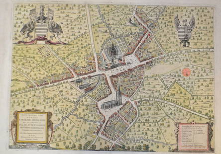
Sold201518th C French Map Of SteenvoordePLOUICH, Vedastus du -" Illvstrissimo viro domino" .The city of Steenvoorde is a small town located north of France. The city of Steenvoorde is located in the department of Nord of the french region.See Sold Price
4 days LeftMark Louis Weseloh Estate LiquidationsJodocus Hondius Hand Colored Map. Region of Poitou France, c.1600’s. 22 ½” x 19 $300
Jun 23East Coast Fine Arts LLC1777 US Revolutionary War Map French Brion de la Tour Theatre de Guerre$1,000
7 days LeftGOLDFIELD AUCTIONGIRARD & BARRERE, Paris - Luminous glass globe, tripod mahogany base, zodiac signs on wooden belt,€1,800
12 hrs LeftRiverfront Auctions"Arx Carolina" hand-colored engraving by Arnold Montanus c. 1671$100(1 bid)
7 days LeftGOLDFIELD AUCTIONCarton from Aubusson Tapestry "Eagle in the undergrowth" oil on canvas project, 19th century.€100(1 bid)
7 days LeftGOLDFIELD AUCTIONLino SABATTINI (1925-2016) for Christofle - Jewellery box in silver-plated metal and Plexiglas.€240(2 bids)
7 days LeftGOLDFIELD AUCTIONRene LALIQUE (1860-1945) Mascotte radiator cap model "Longchamp" 1929.€300
7 days LeftGOLDFIELD AUCTIONDAUM Nancy - Louis MAJORELLE (1859-1926) Marmorated glass tulip lamp on hammered wrought iron frame,€2,000
7 days LeftGOLDFIELD AUCTIONLouis MAJORELLE (1859-1926) Walnut desk, fruitwood veneer, bronze lock and key.€2,000
7 days LeftGOLDFIELD AUCTIONEugene ROUSSEAU (1827-1890) Japanese vase in multi-layered tinted crystal, lower layer cracked,€500
7 days LeftGOLDFIELD AUCTIONGOYARD Aine Paris - Superb 1920s cabin trunk covered in goyardine canvas and protected by lozine€800(1 bid)
7 days LeftGOLDFIELD AUCTIONEmile GALLE (1846-1904) - Series of six dinner plates from the "Ancolie" floral service created in€1,200
7 days LeftGOLDFIELD AUCTIONFrancois Raoul LARCHE (1860-1912) "Vingt ans" Sculpture in bronze with a medallic patina, circa€200
7 days LeftGOLDFIELD AUCTIONRene LALIQUE (1860-1945) Molinard - Calendal model perfume atomiser in moulded pressed glass, 1927.€300
7 days LeftGOLDFIELD AUCTIONAn ormolu and chased clock, allegory of the arts with Putti, dial signed Cherier in Paris, Louis XVI€400
7 days LeftGOLDFIELD AUCTIONMax Le VERRIER (1891-1973) "Le challenge" Sculpture in bronze with a green patina on a beige stone€400
7 days LeftGOLDFIELD AUCTIONRene LALIQUE (1860-1945) "Laurier Esterel" vase in opalescent glass with grey patina, 1923.€600
7 days LeftGOLDFIELD AUCTIONMarcel BOURAINE (1886-1948) "Pierrot lunaire" Silver-plated metal lamp on marble base (cracked),€1,200
7 days LeftGOLDFIELD AUCTIONAlbert Ernest CARRIER-BELLEUSE (1824-1887) "Nymph and Triton" Large brown patina bronze on red€1,500
7 days LeftGOLDFIELD AUCTIONJean-Baptiste CARPEAUX (1827-1875) "Le Rieur aux pampres" Carrara marble sculpture, signed, 19th€2,400


![France.- Ortelius (Abraham) Four sheets with seven maps: NO RESERVE France.- Ortelius (Abraham) Four sheets with seven maps of France, including the Artois region of north eastern France [Atrebatum Regionis...], Calais and Boulogne [Caletensium et Bononiens](https://p1.liveauctioneers.com/5458/236692/122702398_1_x.jpg?height=310&quality=70&version=1644332470)


![[GREAT LAKES REGION]. ROBERT DE VAUGONDY, Didier: [GREAT LAKES REGION]. ROBERT DE VAUGONDY, Didier (1723–1786). Partie De l’Amerique Septent? qui comprend La Nouvelle France ou Le Canada. Paris, 1755. Hand–colored engraved map of ea](https://p1.liveauctioneers.com/928/212515/108628837_1_x.jpg?height=310&quality=70&version=1627420959)