Sold20241661 GEOGRAPHY w/ folded MAP antique in LATINClüver, Philipp Introductionis ad geographiam, libri sex [...] Paris; 1661 bound with: Labbé, Philippe Breviario Geographiae Episcopalis, aliisque accessionibus ad Franco-Galliam spectantibus Paris,See Sold Price
Sold20241704 BIBLE HISTORY CHRONOLOGY & GEOGRAPHY ILLUSTRATED w/ MAPS antique VELLUMIntroductio In Lectionem Novi Testamenti In qua, quae ad rem criticam Historiam, Chronologiam et Geographiam pertinent, Breuiter et Perspicue Exponuntur Johann Georg Pritius (Georgii Pritii) (IntroducSee Sold Price
20241897 HISTORICAL GEOGRAPHY of BRITISH COLONIES - AFRICA w/ MAPS V.4 antiqueHISTORICAL GEOGRAPHY of BRITISH COLONIES by C.P.LUCAS Vol. IV SOUTH and EAST AFRICA Part I: Historical Part II: Geographical Illustrated w/ maps Size 6 by 9.5" Very good condition, minor wear Text inSee Sold Price
Sold20231642 HISTORY of ULTRECHT NETHERLANDS antique VELLUM BOUND FOLIO in LATIN w/ MAPDE EPISCOPIS ULTRAIECTINIS, RECOGNITI ET NOTIS HISTORICIS ILLUSTRATI AB ARN. BUCHELIO BATAVO I.C. ACCEDUNT LAMB. HORTENSII MONTFORTII SECESSIONUM ULTRAIECTINARUM LIBRI, ET SIFFRIDI PETRI FRISII APPENDSee Sold Price
Sold2021Colton Railroad and County Map United States 1878Colton, after G. W., Colton's Railroad and County Map of the United States, The Canadas, &c, 1878, antique map on paper, folded as originally issued, 33 x 42 inches, in a wood frame 36.5 x 47.5 inchesSee Sold Price
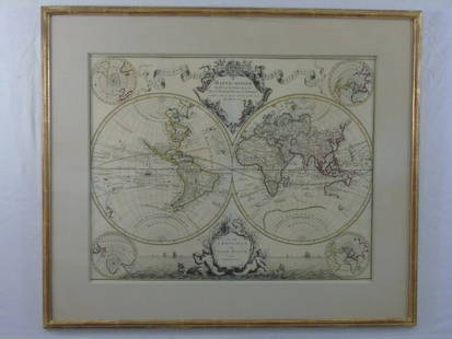
Sold2021Antique Italian MapAntique Italian map in Latin. [Image: 13" H x 15" W; Frame: 21" H x 25" W]. As is.See Sold Price
Sold2017Scholes: Antique Map of North America, 1799Map: A Map of North America from the Latest Authorities 1799. Publication Date: 1799 Authors: J. LOW, SCOLES sc. Publisher: J. LOW Size: Octavo – 7.25 H x 8.50 W Inches "Engraved for Paynes GeographSee Sold Price
Sold2018Blaeu: Antique Map of Anglo Saxon Britain, 1645Title/Content of Map: Map of Anglo Saxon Britian Date Printed: 1645 Cartographer: W. Blaeu Material/Medium: Paper Size: 19" x 23" Anglo Saxon Britian. Hand colored copperplate engraved. Latin text onSee Sold Price
Sold2017Jefferys: Antique Map of the West Indies, 1762Map: West Indies. Cartouche of European Traders & Slave at Work Publication Date: 1762 Authors: JEFFERYS, T. Size: Octavo – 6.80 H x 11.50 W Inches Cartouche. From Kitchin's The modern geography. PlSee Sold Price
Sold2017Morse: Antique Map of North America, 1844Map: North America Publication Date: 1844 Authors: HARPER & BROTHERS, MORSE, SIDNEY EDWARDS Publisher: HARPER & BROTHERS Size: Quarto – 10.30 H x 8.75 W Inches From S.E. Morse's A system of geographSee Sold Price
Sold20241753 HISTORY of JEWS 18 VOLUMES in FRENCH antique ILLUSTRATED w/ MAPS JUDAICAHistoire du people de dieu. by Berruyer,I.J. 1st and 2nd parts in 18 volumes Paris, Bordelet and The Hague, Neaulme; 1753 With 2 folded engraved maps and 3 folded tables. Size 4 by 6.5" Marbled leatheSee Sold Price
Sold2018Bellin/vander Schley: Antique North Atlantic Chart 1746Map: Carte de l'Ocean Occidental Cartographer: Bellin / vander Schley Place & Date: the Hague / 1746/1747 Size: 17 3/4" x 12 3/4" Condition: b&w; overall age toning, folded as issued Bellin's sSee Sold Price
Sold2016Antique Book of Maps & Geography by Jedidiah MorseAntique Book of Maps & Geography by Jedidiah Morse, Father of Artist and Inventor Samuel F B Morse. Printed in the 1790's. Measures 10"h x 6" w.See Sold Price
Sold20241865 HISTORY of INDIAN WARS in NEW ENGLAND 2 volumes ILLUSTRATED w/ MAP antiqueThe History of The Indian Wars in New England from the First Settlement to the Termination of the War with King Philip, in 1677. by William HUBBARD (1621?-1704) Roxbury, Mass.: printed for W. Elliot WSee Sold Price
Sold20221908 MOROCCO ITS PEOPLE & PLACES 2 VOLUMES illustrated w/ map ANTIQUE travelMOROCCO ITS PEOPLE & PLACES 2 VOLUMES Philadelphia, The John C. Winston Co.; 1908 by Edmondo De Amicis 226 and 253 pages Illustrated in b/w, with color map Very good condition Text in English Size 5 1See Sold Price
Sold20241569 MUNSTER COSMOGRAPHY LEAF w/ MAP antique 16th century1 leaf w/ woodcuts, from S. MUNSTER, Cosmographey (...) (Basel, 1569). With map. Double sided. With padding. Size 7 1/2 by 11 3/4 Pad 9 3/4 by 13 3/4" Text in German Very good condition Reserve: $140.See Sold Price
Sold20241719 BIBLE in DUTCH ILLUSTRATED w/ MAPS antique MASSIVE FOLIO BIBLIAantbooks1 BIBLIA, DAT IS DE GANTSCHE H. SCHRIFTURE, vervattende alle de canonijcke boecken des ouden en des nieuwen testaments (...). Laft Der Hoogha Mgh Heeren Dordrecht, Pieter Keur; 1719 IllustrateSee Sold Price
Sold20231742 HISTORY of JEWS 6 VOLUMES ILLUSTRATED w/ MAPS antique in FRENCH JUDAICAJudaica Prideaux (Humphrey) Histoire Des Juifs Et Des Peuples Voisins Depuis La Décadence Des Royaumes D'Israel & De Juda 6 volumes Paris, Guillaume Cavelier, père, 1742. Titles in red and blackSee Sold Price
Sold2020Colton & Fitch's Intro Geography w/ maps 1870Heading: Author: Colton, George Woolworth and George W. Fitch Title: Colton and Fitch's Introductory School Geography Place Published: New York Publisher:Ivison, Blakeman, Taylor & Co. Date PublSee Sold Price
Sold20221664 BIBLE DUTCH BIBLIA MASSIVE FOLIO w/ CLASPS & MAP antique 11 x 17"Paulus Aertsz. van Ravensteyn / Nicolaes Visscher BIBLIA; dat is: de gantsche H. Schrifture, vervattende alle de canonijcke boecken des Ouden en des Nieuwen Testaments. [ ... ] door last der Hoogh.-moSee Sold Price
Sold20231693 HISTORY of BELGIUM ILLUSTRATED w/ MAP FOLIO antique CHRONICON vellumCHRONICON BALDUINI AVENNENSIS TOPARCHAE BELLIMONTIS SIVE HISTORIA GENEALOGICA COMITUM HANNONIAE ALIORUMQUE PRINCIPUM ANTE ANNOS QU[ADR]INGENTOS CONSCRIPTA [...]. by BAUDOUIN of AVESNES Antwerp; 1693 FSee Sold Price
Sold20231754 ART of WAR 2 VOLUMES ILLUSTRATED w/ 25 MAPS antique L'ART DE LA GUERREESSAI SUR L'ART DE LA GUERRE. by TURPIN de CRISSE, Lancelot 2 volumes Paris; 1754 4to: 9 by 11.5" [10]-443-[1], [4]-4-204-[2] pp.; 25 folding plates - Rare 1st ed. of Turpin de Crissé's treatiseSee Sold Price
Sold20231810s ANCIENT & MODERN ATLAS illustrated w/ 62 MAPS antique volume 6 CyclopaediaVOLUME VI - PLATES The Cyclopaedia; or Universal Dictionary of Arts, Sciences, and Literature ANCIENT & MODERN ATLAS, contains 62 double page MAPS Philadelphia, Samuel F. Bradford and Murray, FairmanSee Sold Price
Sold2016Large Framed World Map w/ Latin InscriptionsLarge Framed World Map w/ Latin Inscriptions. Hand colored. Professionally framed and matted. Titled Mappe Monde. Measures 28 by 33 inches.See Sold Price
1 day LeftJasper521710-1712 BIBLE in GERMAN BIBLIA PENTAPLA 2 VOLUMES w/ MAP antique VELLUM BOUND$550
1 day LeftJasper521817 3 VOYAGES of CAPTAIN COOK 6 vols ILLUSTRATED w/ WORLD MAP antique in FRENCH$1,000
1 day LeftJasper521804 TRAVELS of Ledyard & Lucas in Africa antique w/ MAPS Voyages de MM. Lédyard$240
1 day LeftJasper521882 UNEXPLORED BALUCHISTAN by ERNEST FLOYER antique ILLUSTRATED w/ MAP English$320
Jun 22Swisher Bros. Auction LLCVictorian Style Floor Map w/ Embossed Glass Shade - 68"T / 15"Dia Shade$5
3 days LeftJasper52Antarctica. National Geographic map for the International Geophysical Year 1957$550
Jun 19Flanders AuctionsAn antique map of Ingelumunster and two 'Heerlijkheden van Picquenij', 18th C. (W:42 x H:33 cm)€160
3 days LeftJasper52SALISBURY PLAIN War Department land. MOD Training area. Ordnance Survey 1908 map$420
3 days LeftJasper52SOUTH DOWNS, SOLENT & ISLE OF WIGHT. SE Hampshire & W Sussex coast CARY 1832 map$260
3 days LeftJasper52SOUTH DOWNS, SOLENT & ISLE OF WIGHT. SE Hampshire & W Sussex coast CARY 1832 map$260


![1661 GEOGRAPHY w/ folded MAP antique in LATIN: Clüver, Philipp Introductionis ad geographiam, libri sex [...] Paris; 1661 bound with: Labbé, Philippe Breviario Geographiae Episcopalis, aliisque accessionibus ad Franco-Galliam spectantibus Paris,](https://p1.liveauctioneers.com/5584/318267/170789090_1_x.jpg?height=310&quality=70&version=1707248973)


![Antique Italian Map: Antique Italian map in Latin. [Image: 13" H x 15" W; Frame: 21" H x 25" W]. As is.](https://p1.liveauctioneers.com/1221/202668/104343471_1_x.jpg?height=310&quality=70&version=1622581573)


![1664 BIBLE DUTCH BIBLIA MASSIVE FOLIO w/ CLASPS & MAP antique 11 x 17": Paulus Aertsz. van Ravensteyn / Nicolaes Visscher BIBLIA; dat is: de gantsche H. Schrifture, vervattende alle de canonijcke boecken des Ouden en des Nieuwen Testaments. [ ... ] door last der Hoogh.-mo](https://p1.liveauctioneers.com/5584/248552/129022225_1_x.jpg?height=310&quality=70&version=1653430568)
![1693 HISTORY of BELGIUM ILLUSTRATED w/ MAP FOLIO antique CHRONICON vellum: CHRONICON BALDUINI AVENNENSIS TOPARCHAE BELLIMONTIS SIVE HISTORIA GENEALOGICA COMITUM HANNONIAE ALIORUMQUE PRINCIPUM ANTE ANNOS QU[ADR]INGENTOS CONSCRIPTA [...]. by BAUDOUIN of AVESNES Antwerp; 1693 F](https://p1.liveauctioneers.com/5584/273386/143235584_1_x.jpg?height=310&quality=70&version=1672180773)
![1754 ART of WAR 2 VOLUMES ILLUSTRATED w/ 25 MAPS antique L'ART DE LA GUERRE: ESSAI SUR L'ART DE LA GUERRE. by TURPIN de CRISSE, Lancelot 2 volumes Paris; 1754 4to: 9 by 11.5" [10]-443-[1], [4]-4-204-[2] pp.; 25 folding plates - Rare 1st ed. of Turpin de Crissé's treatise](https://p1.liveauctioneers.com/5584/276533/145377010_1_x.jpg?height=310&quality=70&version=1675202312)