Sold20191720 Strype Ward Map of Portions of City London -- ATitle/Content of Map: 1720 Strype Ward Map of Portions of City London -- A Mapp of Lime Street Ward… Date: 1720, London Cartographer: J Strype Size: 11.9 X 6.9 in. This is a very nice ward map of LoSee Sold Price
Sold20201720 Strype Ward Map of London around St. PaulTitle/Content of Map: 1720 Strype Ward Map of London around St. Paul's Cathedral -- The Wards Of Farington Within And Baynard's Castle Â… Cartographer: J Strype Year/Place: 1720, London Size: 11.8See Sold Price
Sold20201720 Strype Ward Map of Barbican and London Wall AreaTitle/Content of Map: 1720 Strype Ward Map of Barbican and London Wall Area of London -- Creplegate Ward With Its Division Into Parishes … Cartographer: J Strype Year/Place: 1720 London Size: 11.6 XSee Sold Price
Sold20191720 Strype Ward Map of London just East of St. Paul'sTitle/Content of Map: 1720 Strype Ward Map of London just East of St. Paul's Cathedral -- Date: 1720, London Cartographer: J Strype Size: 11.9 X 6.9 in. This is a highly detailed plan of Breadstreet aSee Sold Price
Sold20221720 Strype Map of London Ward by Southwark Bridge on Thames -- Queen Hith Ward and VintryTitle: 1720 Strype Map of London Ward by Southwark Bridge on Thames -- Queen Hith Ward and Vintry Ward… Cartographer: J Strype Year / Place: 1720, London Map Dimension (in.): 11.9 X 6.9 in. ThisSee Sold Price
Sold20191720 Strype Map of London around Cannon Street --Title/Content of Map: 1720 Strype Map of London around Cannon Street -- Walbrook Ward and Dowgate Ward with its Division into Parishes … Date: 1720, London Cartographer: J Strype Size: 12.2 X 7.1 inSee Sold Price
Sold2015Gold mines in eastern OregonHeading: (Oregon) Author: Title: Map Showing Portion of Cracker Creek District, Baker County, Eastern Oregon Gold Fields Place Published: [Baker City, Oregon?] Publisher: Date Published: [c.See Sold Price
Sold20231720 Homann/Haas Map of Eastern Mediterranean and Middle East -- Typus Aetiologicus I…Title: 1720 Homann/Haas Map of Eastern Mediterranean and Middle East -- Typus Aetiologicus I… Cartographer: Homann/Haas Year / Place: 1720, Nurnberg Map Dimension (in.): 11.9 X 15.1 in. This uncSee Sold Price
Sold20171874 Map of Boston. GM Hopkins. This map includes1874 Map of Boston. GM Hopkins. This map includes portions of cities around Boston such as Cambridge, Charleston, Somerville, Chelsea, Brighton, Brookline, West Roxbury, Dorchester, and South Boston.See Sold Price
Sold2020Johnson’s Minnesota & Dakota, 1863Clean and beautifully centered, this map of Minnesota and the eastern portion of Dakota territory comes from an early 1863 edition of Johnson’s Family Atlas. Later 1863 editions of the map feature aSee Sold Price
Sold2017Rand McNally: Antique City Plan of Brooklyn, NY, 1912Title/Content of Map: 'Main Portion Brooklyn ' Brooklyn town city map plan. New York. Date Printed: 1912 Image Size: Approx 27.5 x 33.5cm, 10.75 x 13 inches (Large) Type: Antique colour (color) city pSee Sold Price
Sold2018Scarce 1877 Guide Map of Cleveland - Brooks, SchinkelVery rare pocket map of Cleveland in 1877 folds out to 22.5 x 26.5 inches. Map shows city by wards with good closeup detail of city plan at that time. Very large Euclid Avenue Park. Goes only as far aSee Sold Price
Sold2019Rand, McNally & Co.'s Map of the Central Portion ofTitle: Rand, McNally & Co.'s Map of the Central Portion of Kansas City. Publication Date: c1895 Cartographer: RAND, MCNALLY & CO. Publisher: ENCYCLOPAEDIA BRITANNICA Size: 12.5Height - 9.3Width Rand,See Sold Price
Sold2023[CANADIAN ANTIQUE MAP] FIFTH & SIXTH WARDS, CITY OF HAMILTON. COLOURED. C. 1870S[CANADIAN ANTIQUE MAP] COLOURED ANTIQUE MAP OF FIFTH & SIXTH WARDS, CITY OF HAMILTON. Printed circa 1870s.Image size (approx): 15.1/2"x25.3/4" Original antique map of Fifth & Sixth Wards of the CitySee Sold Price
Sold20211895 Rand McNally Map of New York City [verso] BrooklynTitle: 1895 Rand McNally Map of New York City [verso] Brooklyn -- Map of the Southern Portion of New York City [verso] Brooklyn Cartographer: Rand McNally Year / Place: 1895, Chicago Map Dimension (inSee Sold Price
Sold2023PART OF WARD 12 NEW YORK CITY STREET MAPPlate 31, part of ward 12 New York City h. 18-1/2 w. 28-1/2 in. (sight) overall: 24-1/4 x 33-3/4 in. (frame) Provenance: Collection of a prominent Fifth Avenue doctor, New York, NY [In Situ Item] ThisSee Sold Price
Sold2023Trinidad Island. Eastern Part. West Indies. ADMIRALTY sea chart 1869 (1950) mapTrinidad Island - Eastern Portion' by Bocas Del Dragon to Icacos point from the surveys by Commr. Alun Jones, R.N., and the Officers of H.M. Surveying Ship "Challenger" 1936. Eastern portion of Gulf oSee Sold Price
Sold2021Scarce h/c map of Idaho, Cram 1882Early and scarce county map of Southern Idaho Territory showing limited railroads only in eastern portion of the state. One of them leads to and ends at Hailey, site of early silver mining (the map inSee Sold Price
Sold2017Colton: Antique Map of Minnesota, 1867Huge 1867 Minnesota map by Colton. Very fine example of this early large format map. Finely engraved map of the state with inset of the north-eastern portion at upper right. Highly detailed with identSee Sold Price
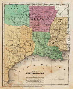
Sold20211847 map showing east Texas/Indian TerritoryInteresting map of the southern U. S. in 1847. Map by Cady & Burgess from Roswell SmithÂ’s 1847 Quarto Atlas. Eastern portion of Texas shown along with most of Indian Territory. Also includes ArkanSee Sold Price
Sold2017Map of New York City[ANTIQUARIAN MAP; NEW YORK CITY] MAP OF NEW YORK CITY Showing Portions of Brooklyn, Jersey City, and Westchester Co., Rand-McNally & Co., 1899, original large map 27” high x 22” across including aSee Sold Price
Sold2019W. Williams, "The Southern and South-Western StatesW. Williams, "The Southern and South-Western States (inset – Texas & inset – map of Eastern Virginia), 1849, H. - 13 in., W. - 18 1/2 in.See Sold Price
Sold20221720 J. STRYPE HAND-COLORED PLAN OF LONDONGenuine 18th century hand-colored copper engraving, titled "A New Plan of the City of London, Westminster, and Southwark". Published in A Survey of London by John Strype (1720); attributed to engraverSee Sold Price
Sold2019Johnson Map of Eastern CanadaJOHNSON, Alvin Jewitt (1827-1884) & WARD, Benjamin P. (19th Century). Johnson’s New Brunswick, Nova Scotia, Newfoundland and Prince Edward Id. Lithographed map with hand color from the New IlluSee Sold Price
7 days LeftHolabird Western Americana CollectionsAtlas Pages Stark Cty, OH & Townships . c1870-1900's. [180168]$50
4 days LeftJasper521852 Norwood Geological Map of Wisconsin and Minnesota -- Geological Map of Parts of Minnesota and$55
Jun 12Dan Morphy AuctionsGEOLOGY OF THE BLACK AND GRAND RAPIDS OF TEXAS INCLUDING THE EASTERN AND WESTERN CROSS TIMBERS,$100
BonhamsLONDON STOW (JOHN) A Survey of the Cities of London and Westminster... Corrected, Improved, and ...£900
Jun 08Early American History Auctions1853 Map of Portion of British North America and Gulf of St. Lawrence, by Henry Perley$260
2 days LeftGold Coast Auctioneers17th-19th c. French Wall Art Collection Map City Sea Scapes Scenes etc.$50
7 days LeftFreeman's | HindmanHOMANN, Johann Baptist. Amplissimae Regionis Mississipi Seu Provinciae Ludovicianae. Nuremburg, [ca$400(1 bid)
Jun 08Early American History Auctions1720 Colonial Northumberland County Virginia Manuscript Deed and Map Plot$400
Jun 08Auction WallstreetEngraving on glass Johannes Kip La Ville de Londres Prospectus Londinensis City of London$50(1 bid)
Jun 15Crescent City Auction GalleryPair of New Orleans Sanborn Fire Insurance Mock-Up Skeleton Maps of the French Quarter, 1910-1911,$250
Jun 14Crescent City Auction GalleryEuropean Flanged Steel Battle Mace, 17th c., L.- 27 1/2 in. Dia.- 5 1/4 in.$800(1 bid)
Jun 14Crescent City Auction GalleryAfter Marie Adrien Persac (French/Louisiana, 1823-1873), "Plantations on the Mississippi River from$325


![Gold mines in eastern Oregon: Heading: (Oregon) Author: Title: Map Showing Portion of Cracker Creek District, Baker County, Eastern Oregon Gold Fields Place Published: [Baker City, Oregon?] Publisher: Date Published: [c.](https://p1.liveauctioneers.com/642/82410/42716591_1_x.jpg?height=310&quality=70&version=1448291517)


![[CANADIAN ANTIQUE MAP] FIFTH & SIXTH WARDS, CITY OF HAMILTON. COLOURED. C. 1870S: [CANADIAN ANTIQUE MAP] COLOURED ANTIQUE MAP OF FIFTH & SIXTH WARDS, CITY OF HAMILTON. Printed circa 1870s.Image size (approx): 15.1/2"x25.3/4" Original antique map of Fifth & Sixth Wards of the City](https://p1.liveauctioneers.com/8321/286473/155233340_1_x.jpg?height=310&quality=70&version=1686787412)
![1895 Rand McNally Map of New York City [verso] Brooklyn: Title: 1895 Rand McNally Map of New York City [verso] Brooklyn -- Map of the Southern Portion of New York City [verso] Brooklyn Cartographer: Rand McNally Year / Place: 1895, Chicago Map Dimension (in](https://p1.liveauctioneers.com/5584/208108/105911435_1_x.jpg?height=310&quality=70&version=1624395684)
![PART OF WARD 12 NEW YORK CITY STREET MAP: Plate 31, part of ward 12 New York City h. 18-1/2 w. 28-1/2 in. (sight) overall: 24-1/4 x 33-3/4 in. (frame) Provenance: Collection of a prominent Fifth Avenue doctor, New York, NY [In Situ Item] This](https://p1.liveauctioneers.com/522/308015/164649563_1_x.jpg?height=310&quality=70&version=1698947202)


![Map of New York City: [ANTIQUARIAN MAP; NEW YORK CITY] MAP OF NEW YORK CITY Showing Portions of Brooklyn, Jersey City, and Westchester Co., Rand-McNally & Co., 1899, original large map 27” high x 22” across including a](https://p1.liveauctioneers.com/1163/104811/53672586_1_x.jpg?height=310&quality=70&version=1496428876)


![Atlas Pages Stark Cty, OH & Townships . c1870-1900's. [180168] (1 of 6)](https://p1.liveauctioneers.com/2699/331495/178785794_1_x.jpg?height=282&quality=70&version=1717094933)


