Sold20211847 map showing east Texas/Indian TerritoryInteresting map of the southern U. S. in 1847. Map by Cady & Burgess from Roswell SmithÂ’s 1847 Quarto Atlas. Eastern portion of Texas shown along with most of Indian Territory. Also includes ArkanSee Sold Price
Sold2023Civil War era 1863 map of Mexico & Caribbean nationsLovely and vintage double-page map showing all of Mexico, Central America, Texas, Indian Territory and states of the Deep South during the middle of the American Civil War. Map has an 1860 copyright bSee Sold Price
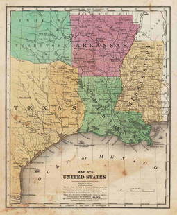
Sold2017Fullarton: Antique Map of Texas & Indian Territory 1860Map: 1860 Fullarton Map of Texas (East/Central), Indian Territory, Louisiana and Arkansas -- United States North America According to Calvin Smith& Tanner . . . South Central Section. Comprising TexasSee Sold Price
Sold20231847 MAP OF UNITED STATES.Published New York, 1847, by Pratt, Woodford & Co., hand colored engraved map on paper. "Olney's Outline Map for Common Schools and General Use" showing the United States and Territories with correspoSee Sold Price
Sold2022Uncommon Texas/Indian Territory RR map, 1890Unusual map of Texas and Indian Territory by McNally showing highly detailed picture of Native American tribe locations in Indian Territory. Presents a thorough overview of railroad lines in the regioSee Sold Price
Sold2021Scarce 1847 map of Western Terr. Of the U. S.Title: Scarce 1847 map of Western Terr. Of the U. S. Description: Great and uncommon map showing the transitional boundaries of the American West c1840s. massive Oregon Territory, encompassing futureSee Sold Price
Sold2022Pre-railroad 1847 map of prairie statesSchool atlas map showing just one railroad line—a short route from Chicago west just a few counties to La Salle county. Railroads had not yet broken into the prairie states. Iowa Territory withSee Sold Price
Sold2019Map of Predominating Sex Showing the Local Excess ofTitle: Map of Predominating Sex Showing the Local Excess of Males Or Of Females in the Distribution Of Population Over The Territory Of The United States East Of The 100th Meridian. Publication Date:See Sold Price
Sold2022WILLIAM H. LIZARS. MAP OF POLAND & LITHUANIA 1828Lizars, William Home. POLAND AND LITHUANIA (Edinburgh, ca. 1828). Engraved map showing territories of the formerPolish-Lithuanian Commonwealth, including Belarus and Latvia, large parts of Ukraine andSee Sold Price
Sold2017Two Emanuel Bowen Maps Showing the East Coastfrom A Complete System of Geography (London, 1747), copperplate engravings with outline color as follows: A New and Accurate Map of New Jersey, Pennsylvania, New York and New England and A New & AccurSee Sold Price
Sold20171882 Historical Hand Atlas, H. H. Hardesty Map1882 Historical Hand Atlas Illustrated, H. H. Hardesty 11.5 X 15. This Hard-to-find Atlas Has Been Rebound—it Will Look Great on Your Shelf. Several State Maps (texas/indian Territory, California/laSee Sold Price
Sold2023Western HemispherePublication Date: 1830 Title: Western Hemisphere Cartographer: HALL, SIDNEY Publisher: LONGMAN, REES, ORME, BROWN AND GREEN Height: 16 Width: 16 Detailed hemisphere map showing "Western Territories" aSee Sold Price
Sold2017Johnson: Antique Map of Australia, 1863Title/Content of Map: 1863 Johnson's Map of Australia -- Johnson's Australia Date Printed: 1863, New York Cartographer: A Johnson Size: 13.1 x 15.2 in. An eloquent map showing six territories of AustrSee Sold Price
Sold2017Johnson: Map of Australia, 18611861 Johnson's Map of Australia -- Johnson's Australia. An eloquent map showing six territories of Australia at the time: New South Wales, Victoria, Van Diemen Land, and West, North and South AustraliSee Sold Price
Sold20211869 McNally Map of Texas, Indian Territory and NewTitle: 1869 McNally Map of Texas, Indian Territory and New Mexico -- Texas, New Mexico, and Indian Territory Cartographer: F McNally Year / Place: 1869, New York Map Dimension (in.): 8.3 X 10.6 in. ThSee Sold Price
Sold2017Cram: Antique Map of Texas, Indian Territory, ArkansasTitle/Content of Map: 1885 Cram Map of Texas, [verso] Indian Territory and Arkansas -- Texas, [verso] Indian Ty; Arkansas Date Printed: 1885, Chicago Cartographer: G Cram Size: 12 x 17 in. This is a nSee Sold Price
Sold2017Rand McNally: Antique Map of Texas & Indian TerritoryMap: 1895 Rand McNally Map of Texas and Indian Territory/Oklahoma -- Texas; Oklahoma and Indian Territory Cartographer: Rand McNally Year / Place: 1895 Chicago Map Dimensions: 9.2 x 12.5 in. ConditionSee Sold Price
Sold2017Rand McNally: Antique Map of Texas & Indian TerritoryTitle/Content of Map: 1895 Rand McNally Map of Texas and Indian Territory/Oklahoma -- Texas; Oklahoma and Indian Territory Date Printed: 1895 Chicago Cartographer: Rand McNally Size: 9.2 x 12.5 in. CoSee Sold Price
Sold20231833 map of Tennessee showing Cherokee TerritoryExcellent engraving with original hand coloring. Map of the state of Tennessee showing early county divisions. Published after the passage of the 1830 Indian Removal Act, but before the Cherokee RemovSee Sold Price
Sold2022Early 1847 school atlas map of East Coast statesEarly map of Maryland, Virginia, North Carolina and Delaware from Smith’s Quarto Geography published 1848 by Cady & Burgess. Very few railroad lines shown, as the industry was still in its infanSee Sold Price
Sold2018Map of Palestine - Woodcut - Lyon, 1535Tabula Terre Sanctae. Map of Palestine. Woodcut from "Geographia" by Ptolemy Claudius, edited by Michael Servetus. [Lyon, 1535]. Map of Palestine, showing the territories of the Tribes of Israel. TheSee Sold Price
Sold2018Map of the United StatesTitle/Content of Map: Map of the United States Date Printed: 1838 Cartographer: ANONYMOUS Material/Medium: Size: 11.6X14.5 Map showing topography, states, lg. MO territory, Northwestern territory (WI,See Sold Price
Sold2022Wonderful 1872 map of Alaska with orig. hand coloringVery nice and uncommon two-page map titled “Northwestern America showing the Territory ceded by Russia to the United States.” Map was published by H. H. Lloyd in 1872, just five years afteSee Sold Price
Sold2017Mitchell: Map of North Western America/Alaska, 1870Map: North Western America showing the territory ceded by Russia to the United States Cartographer: S. A. Mitchell Place & Date: Philadelphia / 1870 Size: 14 1/2" x 11 5/8" Condition: full color; lighSee Sold Price
Jun 12Dan Morphy AuctionsPLATE CXIII. MAP OF INDIAN TERRITORY SHOWING DISTRIBUTION OF WOODLAND” FROM THE TWENTY-FIRST$100
5 days LeftJasper52WEST AFRICA explorers' routes. Beaufort Gray Park Dochard Caillie. SDUK 1874 map$40
Jun 08Simpson Galleries, LLC.J.H. Young (1792-1870) AN AMERICAN FEDERAL PERIOD MAP, "Mitchell's Travellers Guide Through the$500
4 days LeftJasper521902 Cram Map of New York City [verso] Washington DC [verso] Baltimore -- New York [verso]$60
4 days LeftJasper521855 Gunnison Map of Missouri and Kansas -- Map No. 1 From the Western Boundary of Missouri to the$55
6 days LeftHolabird Western Americana CollectionsEarly French Map of East Coast & Canada [179301]$200
Featured4 days LeftJasper52Map Showing Existing Levees and Work Done On Them During Season 1904-1905$60
Jul 11Dan Morphy AuctionsRARE INDEPENDENT GASOLINE & MOTOR OIL FRAMED GRAPHIC HIGHWAY MAP OF ILLINOIS.$125
4 days LeftJasper521893 Civil War Map of Siege of Yorktown, Battle of Siloh and Army of Ohio Operations -- Plan of$55


![Cram: Antique Map of Texas, Indian Territory, Arkansas: Title/Content of Map: 1885 Cram Map of Texas, [verso] Indian Territory and Arkansas -- Texas, [verso] Indian Ty; Arkansas Date Printed: 1885, Chicago Cartographer: G Cram Size: 12 x 17 in. This is a n](https://p1.liveauctioneers.com/5584/113749/58452563_1_x.jpg?height=310&quality=70&version=1513734097)


![Map of Palestine - Woodcut - Lyon, 1535: Tabula Terre Sanctae. Map of Palestine. Woodcut from "Geographia" by Ptolemy Claudius, edited by Michael Servetus. [Lyon, 1535]. Map of Palestine, showing the territories of the Tribes of Israel. The](https://p1.liveauctioneers.com/1980/117218/60259208_1_x.jpg?height=310&quality=70&version=1520155929)


![1902 Cram Map of New York City [verso] Washington DC [verso] Baltimore -- New York [verso] (1 of 3)](https://p1.liveauctioneers.com/5584/331064/178466310_1_x.jpg?height=282&quality=70&version=1716924723)


![Early French Map of East Coast & Canada [179301] (1 of 1)](https://p1.liveauctioneers.com/2699/331495/178785745_1_x.jpg?height=282&quality=70&version=1717094933)

![British Plantation Map of the Americas [179303] (1 of 1)](https://p1.liveauctioneers.com/2699/331495/178785748_1_x.jpg?height=282&quality=70&version=1717094933)


![Pittsburg [Sic] and Vicinity. (1 of 1)](https://p1.liveauctioneers.com/5584/331064/178466317_1_x.jpg?height=282&quality=70&version=1716924723)


