Sold20201756 Cole Map of Paddington to Islington in London -- ATitle/Content of Map: 1756 Cole Map of Paddington to Islington in London -- A Plan of the Intended New Road, from Padington to Islington Date: 1756, London Cartographer: B ColeSize: 6 X 18.5 in. ThisSee Sold Price
Sold2018London Farrington Ward Aquatint Map B. Cole EngravingCirca 1756 by B. Cole Copper Engraving. Framed. Sight: 15.25 in. H x 19.375 in. W, Frame: 22.25 in. H x 25.875 in. W x .75 in. D.See Sold Price
Sold2023Benjamin Cole, Map of Wards of LondonBenjamin Cole (English, 1695-1766), 18th century hand-colored engraving depicting the Baynards Castle Ward and Farringdon Ward, 14 1/2" x 18 1/2" sight size, 23 3/4" x 27 3/4" framed.See Sold Price
Sold20187 maps by Benjamin Cole: London parishes, wards.[Britain] 7 maps of parishes and wards in London engraved by Benjamin Cole. All but the last listed have a dedication in the lower margin to the ward’s alderman, 1754 or 1755. Decorative cartouches,See Sold Price
Sold20231756 Thomas Kitchin Pennsylvania Map Hand Colored1756 Thomas Kitchin A Map of the Province of Pennsilvania. French & Indian War era engraved map from London Magazine December 1756. 7 x 9 inches in matt.See Sold Price
Sold2020Hinton (Pub) 1756 Map of Hemispheres, Atlantic etcCopper Plate Published 1754-56 by John Hinton, London for "A New and Universal Dictionary of Arts and Sciences"Paper Size: 16 x 10 inch (40 x 26cm) Good ConditionSee Sold Price
Sold20191843 Cole Map of Worchestershire -- WorchestershireTitle: 1843 Cole Map of Worchestershire -- Worchestershire Cartographer: G Cole Date: 1843 c., London Size: 6.9 X 9.2 in. Additional Information: This is a very nice map of Warwickshire, an English coSee Sold Price
Sold20221756 GENTLEMANS MAGAZINE, w/Caribbee Islands MAPHistoric Maps 1756 French & Indian War Map of the "Caribbee Islands" August 1756-Dated French & Indian War, THE GENTLEMAN'S MAGAZINE with its Map, London, England, Very Fine. Published By Sylvanus UrbSee Sold Price
Sold2020Maps 1756 Pair. Surveying a Harbour, Mercator's Proj.Copper Plates Published 1754-55, London for "A New and Complete Dictionary of Arts and Sciences" by a Society of Gentlemen. Paper Size: 8.5 x 5 inch (22 x 14cm) Minor toning/staining on one, Good CondSee Sold Price
Sold2020Maps 1756 Pair. Surveying a Harbour, Mercator's Proj.Copper Plates Published 1754-55, London for "A New and Complete Dictionary of Arts and Sciences" by a Society of Gentlemen. Paper Size: 8.5 x 5 inch (22 x 14cm) Minor toning/staining on one, Good CondSee Sold Price
Sold2023BAYSWATER MAIDA VALE Paddington Bayswater Westbourne Park St Johns Wood 1900 mapTitle: BAYSWATER MAIDA VALE Paddington Bayswater Westbourne Park St Johns Wood 1900 map Description: Sheet 43 from Bacon's 1900 London street atlas covering part of West London including Paddington, BSee Sold Price
Sold2022Thomas Kitchen, World Map Plate, 1756KITCHEN, THOMAS. "The World from the Best Authorities," from Guthries' Geographical Grammer, London, 1756. 7 5/8" x 14 7/8" (sight); 12 3/4" x 20" (frame). What can be seen is in overall good conditioSee Sold Price
Sold2020Edward Wells Map of South America ca. 1700-1738Edward Wells (1667–1727), engraved by Benjamin Cole, "A New Map of South America, Shewing it's General Divisions, Chief Cities & Towns; Rivers, Mountains & c," London, ca. 1700-1738. Hand colorSee Sold Price
Sold2022Edward Wells A New Map of South America, 1700Edward Wells (1667-1727), engraved by Benjamin Cole, "A New Map of South America Shewing its General Divisions, Chief Cities & Towns; Rivers, Mountains & c.", London, circa 1700, hand colored engravedSee Sold Price
Sold2017Engraving: A Map of the Caribbee Islands, 1756. LondonThe foldout map from The Gentlemans Magazine, London, v.26, August 1756. Opposite pg. 368 Decorative cartouche with title: A Map of the Caribbee Islands; Shewing Which Belong to England, France, SpainSee Sold Price
Sold20191756 Magazine Colonial America Map of SpainThe January 1756 issue of “Gentleman’s Magazine”, printed at London with content related to America including Pennsylvania disputes, cultivation of American Fir trees, and on American settlementSee Sold Price
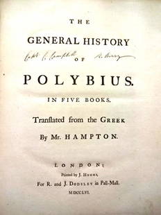
Sold20221756 General History of Polybius MapsTitle: 1756 General History of Polybius Maps Description: "The General History of Polybius in Five Books. Translated from the Greek by Mr. Hampton", printed at London by J. Hughes for R and J Dodsley,See Sold Price
Sold2023LONDON MAP:LONDON MAP: LONDON MAP: Cary's New and Accurate Plan of London and Westminster, the Borough of Southwark and parts adjacent: viz. Kensington, Chelsea, Islington, Hackney, Walworth, Newington &c with aSee Sold Price
Sold2018Map of French & Indian War theatre in 1756Heading: (North America - New England) Author: Anonymous Title: A Map of that Part of America which was the Principal Seat of War, in 1756 Place Published: London Publisher: Date Published: 1See Sold Price
Sold2024Thomas Cole Clock Strut ClockDESCRIPTION: Thomas Cole strut clock A fine engraved giant octagonal strut timepiece by Thomas Cole, London, no. 1457, retailed by Tegelsten & Thornley, St. Petersburg Movement: Going barrel, verticalSee Sold Price
Sold2015Kingdom of IrelandJohn Speed (1552-1629). Engraved map. London: 1610 (1676). 17 1/4 x 22 inches. A rare, early printing of John Speed’s renowned map of Ireland. The map is decorated with a panel of costume figures deSee Sold Price
Sold2022Faden Map of the Battle of Hobkirk's Kill, Revolutionary War, 1781FADEN, William (1749 – 1836). Sketch of the Battle of Hobkirks Hill, near Camden on the 25th April, 1781. Engraved map. London: Faden, Aug. 1, 1783. 21 3/4" x 15 1/8" sheet. This RevolutionarySee Sold Price
Sold2016A NEW MAP OF THE WHOLE CONTINENT OF AMERICA. EngravedA NEW MAP OF THE WHOLE CONTINENT OF AMERICA. Engraved and colored map. London, by Laurie & Whittle, May 1794. 101 x 118 cmSee Sold Price
Sold2024An English Two-Day Ship's ChronometerAn English Two-Day Ship's Chronometer Usher and Cole, London, Late 19th/Early 20th Century the case, dial and works all stamped '2224'. Height of case 7 1/2 x width 7 1/4 x depth 7 1/4 inches (closed)See Sold Price
7 days LeftJasper52Parishes of St Andrews, Holbourn… Clerkenwell Old Street Islington COLE 1756 map$550
7 days LeftJasper52Descriptive map of London Poverty. BOOTH. NW - West End Marylebone Mayfair 1889$3,200
Jun 13Forum AuctionsLondon.- Mogg (Edward) An Entire New Plan of the Cities of London & Westminster with the Borough of£100
7 days LeftJasper52BOOTH /LSE POVERTY MAP Willesden Acton Hammersmith Fulham Brent W Hampstead 1930$340
9 hrs LeftHolabird Western Americana CollectionsJohn Fremont Library of Books (6) c1845-1970 [179374]$500
Jun 18DOYLE Auctioneers & AppraisersSet of Twelve Satirical Anthropomorphic Maps of Europe$400(1 bid)
2 days LeftPotter & Potter AuctionsROWLANDSON, Thomas (1756 – 1827). Bartholomew Fair. London:...$250
Jun 13Swann Auction Galleries(HONDURAS -- ROATAN ISLAND.) Lieutenant Henry Barnsley; and William H. Toms, engraver. A Draught of$750


![7 maps by Benjamin Cole: London parishes, wards.: [Britain] 7 maps of parishes and wards in London engraved by Benjamin Cole. All but the last listed have a dedication in the lower margin to the ward’s alderman, 1754 or 1755. Decorative cartouches,](https://p1.liveauctioneers.com/179/117971/60557713_1_x.jpg?height=310&quality=70&version=1520636872)


![John Fremont Library of Books (6) c1845-1970 [179374] (1 of 7)](https://p1.liveauctioneers.com/2699/331494/178785501_1_x.jpg?height=282&quality=70&version=1717094654)


![[MAP]. SPEED, John. A New Mappe of the Romane Empire. 1676. (1 of 2)](https://p1.liveauctioneers.com/197/329395/177650541_1_x.jpg?height=282&quality=70&version=1715364962)
![British Plantation Map of the Americas [179303] (1 of 1)](https://p1.liveauctioneers.com/2699/331495/178785748_1_x.jpg?height=282&quality=70&version=1717094933)


