Sold20191766 Beautiful Handcolored Map Cayenne1766 hand colored engraved map and plan “Land-Kaart van het Eiland en de Volkplanting van Cayenne aus de Kust van Zuid-Amerika”, by Isaak Tirion,. Fine, close right margin. Measures 18 x 16”, foSee Sold Price
Sold20181773 Hand Colored Bellin Map of MexicoHandcolored map of Mexico by Jacques Bellin, circa 1773, printed at Amsterdam. Fine condition, measures 16.5 x 10.5”. Please note that this lot has a confidential reserve. When you leave a bid in adSee Sold Price
Sold2019Isaak Tirion (1705-1765), "Kaart van hel WestelykIsaak Tirion (1705-1765), "Kaart van hel Westelyk Gedeelte van Nieuw Mexico en van California," 1765, hand colored, H.- 15 in., W.- 19 in.See Sold Price
Sold20191760 Hand Colored Map of Panama TirionFine engraved handcolored map of Panama entitled “Kaart van de Landengte van Panama”, by Isaak Tirion at Amsterdam circa 1760. Measures 17 x 16”. Reserve: $20.00 Shipping: Domestic: Flat-rate ofSee Sold Price
Sold2023Antique Map of The Holy Land, Dated 1792"Generaale Kaart Van Het Beloofde Land" colored map of The Holy Land, covering present-day Israel and Palestine, bordered by Egypt and Syria. Dated 1792, unframed. [22 x 26 inches]. Dry, losses, creasSee Sold Price
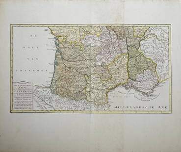
Sold2019Isaak Tirion (1705-1765, Amsterdam), "Nieuwe Kaart vanIsaak Tirion (1705-1765, Amsterdam), "Nieuwe Kaart van het Zuidelykste Gedeltevan Frankryk," 1757, hand colored, H. - 16 7/8 in., W. - 20 7/8 in.See Sold Price
Sold202318th C. Hand Colored Plates, (3pc)Three 18th C. Hand Colored Plates: (1) Circa 1760 hand colored plate titled "GRAND TEMPLE DE MEXICO / GROOTE TEMPEL VAN MEXICO", Shley, good condition, measures: 11" H x 8.5" W, 7.5" H x 11.25" W,(1)See Sold Price
Sold2024J.H. Colton and Co., Map of Mexico, 1854Framed hand-colored map of Mexico and the Southwest, published by J.H. Colton and Company in 1854 sight: 13 x 16 in., sheet: 15.5 x 19.5 in., matting 20 x 22 in. Shipping available for this lot throuSee Sold Price
Sold2020Mercator-Hondius Mexico Map ca. 1638Hendrik Hondius (1588-1651), Jan Jansson (1588-1664), and Gerardus Mercator (1512–1594), "Nova Hispania et Nova Galicia," Amsterdam: Hondius & Jansson, ca. 1638. Hand colored map of Mexico fromSee Sold Price
Sold2022KEULEN, JOHANNES VAN Pas kaart Van de Boght van Florida Met de Canaal Tusschen Florida en Cuba Door.KEULEN, JOHANNES VAN Pas kaart Van de Boght van Florida Met de Canaal Tusschen Florida en Cuba Door. Amsterdam: Gerard Van Keulen, [1734]. Fifth state. Engraved map, hand colored, framed; sheet measurSee Sold Price
Sold2022(REPUBLIC OF TEXAS.) John M. Niles; and Lorraine T. Pease. A Map of Mexico and the Republic of(REPUBLIC OF TEXAS.) John M. Niles; and Lorraine T. Pease. A Map of Mexico and the Republic of Texas. Hand-colored engraved map of Mexico, an independent Texas, and part of the American southeast. 13&See Sold Price
Sold2016Map, Isaak Tirion, Nieuwe Kaart Van EuropaIsaak Tirion (Dutch, 1705-1765), "Nieuwe Kaart Van Europa," hand-colored copper engraving, overall (with frame): 19"h x 21"wSee Sold Price
Sold20191600s View of Mexico Hand Colored Map PrintNot sure when this was printed, but probably 18th or early 19th century. It has been in its current for about 100 years. Image size is 9 x 10.5, but is larger with border. Framed to 12.75 x 14.75. ImaSee Sold Price
Sold2017Bellin: Antique Map of The Mexican Heartland, 1754Map: Carte du Mexique/Kaart van het Mexico Cartographer: Bellin / van der Schley Place & Date: Amsterdam / 1754/1771 Size: 12" x 8 1/2" Condition: wash color; a beautifully colored and preserved exempSee Sold Price
Sold2024Early Map of North AmericaMap of North America Hand Colored Map. Map showing the Mexico when it contained California and Texas, as well as the United States claim on the west coast stretching to meet the Russian Possessions ofSee Sold Price
Sold20201778 Handcolored Map West Indies Gulf of Mexico1778 "The West Indies and Gulf of Mexico from the Latest and Best Observations", by John Lodge. Hand colored map. Fine, measures 15 x 9". Reserve: $80.00 Shipping: Domestic: Flat-rate of $5.00 to anywSee Sold Price
Sold2022Map of Suriname – 18th Century – With Notation ofNieuwe Kaart van Suriname vertonende de stromen en land-streken van Suriname, Comowini, Cottica, en Marawini. Map of Suriname, hand-colored. Amsterdam: J. Ottens, [early 18th century].A detailed map oSee Sold Price
Sold2017Hand-Colored Lithograph Map of the Gulf of MexicoImpressive Hand-Colored Lithograph Map of the Gulf of Mexico, titled "U.S. Coast Survey, A.D. Bache Superintendent, Sketch H, Showing the Progress of the Survey in Section No. 8, 1846-1854", the map iSee Sold Price
Sold2020Kaarte van de Golf van Mexico en het Zuyd-America waarBy: Daniel de la FeuilleDate: 1747 (Published) AmsterdamDimensions: 19.5 x 22.5 inches (50 cm x 57 cm)This is an extremely rare and highly unusual map by the cartographer Daniel de la Feuille, and engSee Sold Price
Sold2017Kitchin: Antique Map Gulf of Mexico / West Indies, 1778Map: Kaart van de Golf van Mexico, de Eilanden en de Aangrenzende Landschappen Cartographer: Thomas Kitchin Place & Date: Amsterdam / 1778 Size: 19 1/8" x 12 1/4" Condition: b&w; a beautifully preservSee Sold Price
Sold2023AFTER NICOLAS SANSON (FRENCH, 1600-1667) MAP OF FLORIDAAFTER NICOLAS SANSON (FRENCH, 1600-1667) MAP OF FLORIDA, hand-colored engraving on laid paper, titled "FLORIDA / zoo als het van de / SPAANSCHEN en FRANSCHEN / wordt bezeten. / door N. Sanson. /See Sold Price
Sold20221848 Outstanding Mexican-American War Period MapPrints 1848 Hand-Colored U.S. & Mexico Broadside & Map titled: ORNAMENTAL MAP of the UNITED STATES & MEXICO 1848-Dated, Hand-colored Lithograph Broadside with Map titled, "ORNAMENTAL MAP OF THE UNITEDSee Sold Price
Sold2021Johannes van Keulen (Dutch, 1654-1715)Johannes van Keulen (Dutch, 1654-1715) , "Pas kaart van de Noord Kust van Espaniola met d Eylanden daar Benoorden", Amsterdam, 1684, hand-colored engraved sea-chart, with inset maps of Tortuga and PorSee Sold Price
Sold2017Elwe: Antique Map of Gulf of Mexico & Caribbean, 1792Map: De Golf van Mexico, de Eilanden en het omleggende Land Cartographer: J. B. Elwe Place & Date: Amsterdam / 1792 Size: 22 3/4" x 19" Condition: Wash and outline color; light overall age toning, minSee Sold Price
Jun 07Freeman's | HindmanGODMAN, Frederick DuCane and Osbert SALVIN, editors. -- MAUDSLEY, A. P. Biologia$1,000
2 days LeftFreeman's | Hindman[MAPS]. A group of 3 engraved maps, most with hand-coloring.$300(1 bid)
7 days LeftArarity AuctionsThomson's 1817 Hand Colored Map Comparative Heights of the World's Great Mountains$50
Jun 08Early American History Auctions1836 Hand-Colored Map, Country Twenty Five Miles Round The City Of New-York Published by D.S. Stone$260


![Antique Map of The Holy Land, Dated 1792: "Generaale Kaart Van Het Beloofde Land" colored map of The Holy Land, covering present-day Israel and Palestine, bordered by Egypt and Syria. Dated 1792, unframed. [22 x 26 inches]. Dry, losses, creas](https://p1.liveauctioneers.com/1221/303742/163342134_1_x.jpg?height=310&quality=70&version=1697564518)


![KEULEN, JOHANNES VAN Pas kaart Van de Boght van Florida Met de Canaal Tusschen Florida en Cuba Door.: KEULEN, JOHANNES VAN Pas kaart Van de Boght van Florida Met de Canaal Tusschen Florida en Cuba Door. Amsterdam: Gerard Van Keulen, [1734]. Fifth state. Engraved map, hand colored, framed; sheet measur](https://p1.liveauctioneers.com/292/250642/130213613_1_x.jpg?height=310&quality=70&version=1654271664)


![Map of Suriname – 18th Century – With Notation of: Nieuwe Kaart van Suriname vertonende de stromen en land-streken van Suriname, Comowini, Cottica, en Marawini. Map of Suriname, hand-colored. Amsterdam: J. Ottens, [early 18th century].A detailed map o](https://p1.liveauctioneers.com/3506/232707/120467405_1_x.jpg?height=310&quality=70&version=1641394058)


![[MAPS]. A group of 3 engraved maps, most with hand-coloring. (1 of 4)](https://p1.liveauctioneers.com/197/328642/177014805_1_x.jpg?height=282&quality=70&version=1714760103)


