Sold2016Map, Isaak Tirion, Nieuwe Kaart Van EuropaIsaak Tirion (Dutch, 1705-1765), "Nieuwe Kaart Van Europa," hand-colored copper engraving, overall (with frame): 19"h x 21"wSee Sold Price
Sold2017MAP, C. 1750, INDIA & SOUTHEAST ASIA, ISAAK TIRIONFramed map of India an nearby countries, "Nieuwe Kaart van India over de Ganges of van Malakka, Siam, Cambodia, Chiampa, Kochinchina, Laos, Pegu, Ava" c. 1750 by Issak Tirion (Dutch, 1705-1765), handSee Sold Price
Sold2019Isaak Tirion (1705-1765, Amsterdam), "Nieuwe Kaart vanIsaak Tirion (1705-1765, Amsterdam), "Nieuwe Kaart van America," 1766, hand colored, H. - 12 in., W. - 13 in.See Sold Price
Sold2019Isaak Tirion (1705-1765, Amsterdam), "Nieuwe Kaart vanIsaak Tirion (1705-1765, Amsterdam), "Nieuwe Kaart van Arabia,"18th c., hand colored, H. - 15 in., W. - 18 in.See Sold Price
Sold2019Isaak Tirion (1705-1765, Amsterdam), "Nieuwe Kaart vanIsaak Tirion (1705-1765, Amsterdam), "Nieuwe Kaart van het Zuidelykste Gedeltevan Frankryk," 1757, hand colored, H. - 16 7/8 in., W. - 20 7/8 in.See Sold Price
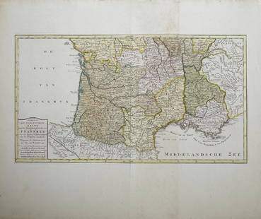
Sold2019Isaak Tirion (1705-1765, Amsterdam), "Nieuwe Kaart vanIsaak Tirion (1705-1765, Amsterdam), "Nieuwe Kaart van Frankryk," hand colored, H. - 17 in., W. -20 1/2 in.See Sold Price
Sold2019Map of England & Wales 1760Heading: (Maps) Author: Tirion, Isaac Title: Nieuwe Kaart van 't Zuider Gedeelte van Groot Britannie behelzende Het Koningryk Engeland… Place Published: Amsterdam Publisher: Date Published: 1See Sold Price
Sold2019Two Maps by Isaak Tirion (1705-1765, Amsterdam),Two Maps by Isaak Tirion (1705-1765, Amsterdam), "Nieuwe Kaart Va restelykste Deel Der Weereld..Scheepstogten der Nederlanderen Naar Westindie," 1754, H. - 14 in., W. - 15 in., and H.- 17 in., W.- 20See Sold Price
Sold20231759 Tirion Map of the Americas -- Nieuwe Kaart van America…Title: 1759 Tirion Map of the Americas -- Nieuwe Kaart van America… Cartographer: I Tirion Year / Place: 1759 c., Amsterdam Map Dimension (in.): 10.8 X 12.5 in. This is wonderful map of the AmerSee Sold Price
Sold20231755 Tirion Map of Eastern North America -- Nieuwe Kaart van de Grootbrittannische Volkplantingen inTitle: 1755 Tirion Map of Eastern North America -- Nieuwe Kaart van de Grootbrittannische Volkplantingen in Noord America Cartographer: I Tirion Year / Place: 1755, Amsterdam Map Dimension (in.): 14.3See Sold Price
Sold2023MAP, Malta, TirionMalta. Isaac Tirion, Nieuwe Kaart van't Eiland Maltha met Gozo en Comino..., from Nieuwe en Beknopte Hand Atlas, 1761 (dated). Hand Color. Handsome, large map of the Maltese Islands with superb detailSee Sold Price
Sold2021Tirion 1733 Map of AsiaDESCRIPTION: Map by Isaac Tirion, engraved by Jacob Keyser. Titled "Nieuwe Kaart van Asia na de alderlaatste Ontdekking int licht gebracht." Depicts Japan, Kamchatka Peninsula, Australia's northern coSee Sold Price
Sold2019India.- Tirion (Isaac) Nieuwe Kaart van t Keyzer RykIndia.- Tirion (Isaac) Nieuwe Kaart van t Keyzer Ryk van den Grooten Mogol, map of The Mughal Empire, which included India, Sri Lanka, Pakistan and Bangladesh, engraved map with hand-colouring on laidSee Sold Price
Sold2017Tirion: Antique Map of the Western Hemisphere, 1754Map: Nieuwe Kaart van het Westelykste Deel der Wereeld Cartographer: Isaac Tirion Place & Date: Amsterdam / 1754 Size: 14 1/4" x 13 1/4" Condition: wash color; light overall age toning; backed to reinSee Sold Price
Sold2017An antique map of Poland by Izaak Tirion, circa 1740An antique map of Poland by Izaak Tirion, circa 1740 Title: [Old Antique map of Poland / Lithuania] Nieuwe Kaart van het Koninkryk Poolen. Author: Tirion, Izaak , Amsterdam, c. 1740. DescriSee Sold Price
Sold20191766 Beautiful Handcolored Map Cayenne1766 hand colored engraved map and plan “Land-Kaart van het Eiland en de Volkplanting van Cayenne aus de Kust van Zuid-Amerika”, by Isaak Tirion,. Fine, close right margin. Measures 18 x 16”, foSee Sold Price
Sold20191760 Hand Colored Map of Panama TirionFine engraved handcolored map of Panama entitled “Kaart van de Landengte van Panama”, by Isaak Tirion at Amsterdam circa 1760. Measures 17 x 16”. Reserve: $20.00 Shipping: Domestic: Flat-rate ofSee Sold Price
Sold2017Moll / Oldmixon: Antique Map of North America, 1721Map: Nieuwe Kaart van Noord Amerika Cartographer: H. Moll / Oldmixon Place & Date: Amsterdam / 1721 Size: 9 3/4" x 6 3/4" Condition: outline color; overall age toning and minor spotting In this DutchSee Sold Price
Sold2019Isaak Tirion (1705-1765), "Kaart van hel WestelykIsaak Tirion (1705-1765), "Kaart van hel Westelyk Gedeelte van Nieuw Mexico en van California," 1765, hand colored, H.- 15 in., W.- 19 in.See Sold Price
Sold2019Attributed to Isaak Tirion (1705-1765), "Kaart Van HetAttributed to Isaak Tirion (1705-1765), "Kaart Van Het Eiland Terre-Nueve, Van Nieuw Schotland/Kanada," c. 1740, engraving on laid paper, H. - 9 in., W. - 13.5 in.See Sold Price
Sold2019Isaak Tirion (1705-1765, Amsterdam), "Nieuwe Kaart vantIsaak Tirion (1705-1765, Amsterdam), "Nieuwe Kaart vant Eilan Ceilon," hand colored, H. - 16 in., W. - 21 in.See Sold Price
Sold2018van Keulen: Antique Map Guadeloupe & Marie Galante 1720Title/Content of Map: Nieuwe Land en Zee Kaart van de Eylanden Guadalupe en Mariegalande Cartographer: van Keulen Place & Date: Amsterdam / 1720/1780 Size: 22 1/2" x 19 7/8" Condition: b&w; overall agSee Sold Price
Sold2022Map of Suriname – 18th Century – With Notation ofNieuwe Kaart van Suriname vertonende de stromen en land-streken van Suriname, Comowini, Cottica, en Marawini. Map of Suriname, hand-colored. Amsterdam: J. Ottens, [early 18th century].A detailed map oSee Sold Price
Sold2019MAP - East Indies - Indonesia. TirionEast Indies - Indonesia. Isaac Tirion, Kaart van de Papoasche Eilanden, 1753 (dated). Hand Color. This beautifully engraved chart spans from the Spice Islands (Sallawatty, Patenta, Gammen, Land van WaSee Sold Price
7 days LeftJasper521788 Gravius World Map -- Kaart van de Geheele Wereld na de Alderlaatste Ontdekkingen$130
Featured7 days LeftJasper521749-59 21 volumes NETHERLANDS HISTORY ILLUSTRATED antique VELLUM BOUND$1,400
1 day LeftSwann Auction Galleries(NEW ENGLAND.) Johannes van Keulen. Pas-Kaart vande Zee Kusten van Niew Nederland Anders Genaamt$2,200
4 days LeftMaison Jules VeilinghuisVarious graphic art about Ghent, lithograph View of Ghent Hemelsoet 1872, Diploma awarded to the Van€140
1 day LeftSwann Auction Galleries(OVID.) Isaak Verburg, translator. De Gedaant-Wisselingen van P. Ovidius Naso,$750
1 day LeftSwann Auction Galleries(TITLE PAGES.) Group of 10 seventeenth-and-eighteenth-century engraved allegorical atlas title$600
1 day LeftSwann Auction Galleries(WORLD.) Nicolas de Fer. Mappe-Monde ou Carte Generale de la Terre.$1,500
Jun 19Flanders AuctionsAn antique map of Ingelumunster and two 'Heerlijkheden van Picquenij', 18th C. (W:42 x H:33 cm)€160
1 day LeftSwann Auction Galleries(DUTCH EAST INDIA COMPANY -- JAVA SEA.) Isaak de Graaf. Manuscript chart of Java, the Java Sea,$80,000
3 days LeftTrillium Antique Prints & Rare BooksDe Jode, Rare, pub. 1593 - Map of Islands including Sicily, Corsica, Sardinia, Cyprus, Candia,$100(1 bid)
3 days LeftTrillium Antique Prints & Rare BooksDe Jode, Rare, pub. 1593 - Maps of the Baltic, North Sea & Russia (Livoniae Provinciae Ac Eivs /$100
18 hrs LeftJasper52Océanique. Partie… Nlle Hollande #57. Victoria Tasmania. VANDERMAELEN 1827 map$280
1 day LeftSwann Auction Galleries(RUSSIA.) Abraham Ortelius. Russiae, Moscoviae et Tartariae Descriptio.$500
1 day LeftSwann Auction Galleries(BRITISH ISLES.) Abraham Ortelius. Angliae, Scotiae, et Hiberniae, sive Britannicar : Insularum$450
1 day LeftSwann Auction Galleries(WORLD and CONTINENTS.) Gerard Mercator; and Jodocus Hondius. Fine set of 5 double-page engraved$11,000
BonhamsBLAEU (WILLEM AND JAN) Toonneel des Aerdrycz, oft Nieuwe Atlas... Tweede Deels, 2 parts in 1 vol...£8,000
1 day LeftSwann Auction GalleriesRUSCELLI, GIROLAMO. Group of 26 double-page engraved maps from La Geografia di Claudio Tolomeo$1,500


![An antique map of Poland by Izaak Tirion, circa 1740: An antique map of Poland by Izaak Tirion, circa 1740 Title: [Old Antique map of Poland / Lithuania] Nieuwe Kaart van het Koninkryk Poolen. Author: Tirion, Izaak , Amsterdam, c. 1740. Descri](https://p1.liveauctioneers.com/6018/113868/58519818_1_x.jpg?height=310&quality=70&version=1513369839)


![Map of Suriname – 18th Century – With Notation of: Nieuwe Kaart van Suriname vertonende de stromen en land-streken van Suriname, Comowini, Cottica, en Marawini. Map of Suriname, hand-colored. Amsterdam: J. Ottens, [early 18th century].A detailed map o](https://p1.liveauctioneers.com/3506/232707/120467405_1_x.jpg?height=310&quality=70&version=1641394058)


