Sold20241839 Italy Map by MoninTitle: 1839 Italy Map by Monin Date/Period: 1839 Materials: Hand colored, engraved Size: 17 1/2” x 12 1/2” 1839. By V. Monin. Paris. Hand-colored, engraved. Good condition, with some foxinSee Sold Price
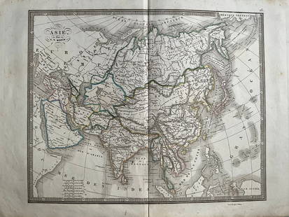
20241839 Asia Map by MoninTitle: 1839 Asia Map by Monin Date/Period: 1839 Materials: Hand colored, engraved Size: 17 1/2 x 12 1/2" This map is an interesting depiction of Asia in 1839 when the continent was still largely unexpSee Sold Price
Sold20231839 Russia Map by MoninTitle: 1839 Russia Map by Monin Date/Period: 1839 Materials: Hand colored, engraved Size: 17 1/2” x 12 1/2” 1839. By V. Monin. Paris. Hand-colored, engraved. Good condition, with some foxiSee Sold Price
Sold20241839 Europe Map by MoninTitle: 1839 Europe Map by Monin Date/Period: 1839 Materials: Hand colored, engraved Size: 17 1/2” x 12 1/2” 1839. By V. Monin. Paris. Hand-colored, engraved. Good condition, with some foxiSee Sold Price
Sold20241839 Known Ancient World Map by MoninTitle: 1839 Known Ancient World Map by Monin Date/Period: 1839 Materials: Hand colored, engraved Size: 17 1/2 x 12 1/2" This map is a fascinating illustration of the world as known to the ancient GreeSee Sold Price
Sold2023Russell & Barclay 1839 Hand Col Map. ItalyHand Colored Copper Engraved Map Published 1823-40, by Fisher & Son, "A Complete Atlas of the World" by John Russell et al. A Very Rare Work which is compiled from the same plates used in different edSee Sold Price
Sold20241839. Map of Australia and Pacific by MoninTitle: 1839. Map of Australia and Pacific by Monin Date/Period: 1839 Materials: Hand colored, engraved Size: 17 1/2 x 12 1/2" This is a map of Australia and the Pacific in 1839 when the continent wasSee Sold Price
Sold20241839 Map of Netherlands and Belgium by MoninTitle: 1839 Map of Netherlands and Belgium by Monin Date/Period: 1839 Materials: Hand colored, engraved Size: 17 1/2” x 12 1/2” Netherlands and Belgium with Luxembourg. 1839. By V. Monin.See Sold Price
Sold20231839 Map of United Kingdom and Ireland by MoninTitle: 1839 Map of United Kingdom and Ireland by Monin Date/Period: 1839 Materials: Hand colored, engraved Size: 17 1/2” x 12 1/2” 1839. By V. Monin. Paris. Hand-colored, engraved. Good coSee Sold Price
Sold20241839 Map of North America with the Republic of Texas. By MoninTitle: 1839 Map of North America with the Republic of Texas. By Monin Date/Period: 1839 Materials: Hand colored, engraved Size: 17 1/2 x 12 1/2" This map is a stunning representation of North AmericaSee Sold Price
Sold20241839 Map of Norway and Sweden with insert of Iceland by MoninTitle: 1839 Map of Norway and Sweden with insert of Iceland by Monin Date/Period: 1839 Materials: Hand colored, engraved Size: 17 1/2” x 12 1/2” 1839. By V. Monin. Paris. Hand-colored, engSee Sold Price
Sold2017Antique 1839 Old Italy Toscana Monte Cristo Old HandAntique 1839 Old Italy Toscana Monte Cristo Old Hand Colored Map Carta Geometrica Approximately 19 1/4" x 15 1/2".See Sold Price
Sold2016Map of Italy. Europe. 1835.Print of hand colored steel engraving titled „Italie“.Author C. V. Monin.Engraved by unknown.From the „Atlas Universel de Geography“ by C. V. Monin. Parsi. 1835.Italy officially the Italian ReSee Sold Price
Sold2015Map of Ancient Italy. Europe. 1835.Print of hand colored steel engraving titled Italie Ancienne“.Author C. V. Monin.Engraved by unknown.From the Atlas Universel de Geography“ by C. V. Monin. Parsi. 1835.Italy officially the ItalianSee Sold Price
Sold20241839. Ancient France (Gaul) by MoninTitle: 1839. Ancient France (Gaul) by Monin Date/Period: 1839 Materials: Hand colored, engraved Size: 17 1/2” x 12 1/2” Map of Ancient France, GAUL. 1839. By V. Monin. Paris. Hand-colored,See Sold Price
Sold20241839. World’s Rivers and Mountains By MoninTitle: 1839. World’s Rivers and Mountains By Monin Date/Period: 1839 Materials: Hand colored, engraved Size: 17 1/2 x 12 1/2" This map is a magnificent illustration of the world's mountains andSee Sold Price
Sold20241839 Germany and Central Europe by MoninTitle/Content: 1839 Germany and Central Europe by Monin Date: 1839 Medium: Hand colored, engraved Description: Map of Germany and all of Central Europe. Including the Austrian Empire. 1839. By V. MoniSee Sold Price
Sold20241839 Balkans with Greece. By MoninTitle: 1839 Balkans with Greece. By Monin Date/Period: 1839 Materials: Hand colored, engraved Size: 17 1/2” x 12 1/2” Map of the entire Balkans with a newly independent Greece. 1839. By V.See Sold Price
Sold20241839. Ancient Germania and Central Europe by MoninTitle/Content: 1839. Ancient Germania and Central Europe by Monin Date: 1839 Medium: Hand colored, engraved Dimensions: 17 1/2" x 12 1/2" Description: Map of Ancient tribal Germany and Central Europe.See Sold Price
Sold2019Tanner: Piedmont and Sardinia, 1839The wonderfully detailed map of the island of Sardinia, divided into the provinces of Sassari and Cagliari, is an inset in the larger-scale map of the Piedmont region in northwestern Italy, the mainlaSee Sold Price
Sold20211839 MAP OF ULSTER COUNTY, NEW YORK, BY DAVID H. BURR,1839 MAP OF ULSTER COUNTY, NEW YORK, BY DAVID H. BURR, STONE & CLARK PUBLISHERS, ITHICA, N.Y. NICELY FRAMED, FROM PROMINENT ELLENVILLE, N.Y. ATTORNEYS OFFICE. MAP MEASURES 22" X 23", NICELY FRAMED, ANSee Sold Price
Sold2021Paolo Petrini (17C.) Hand Colored Naples Italy Map17th to 18th Century panorama map by Paolo Petrini depicting the coastal region of Naples, Italy. Beautifully detailed and colored, with all divisions of the city gorgeous etching artwork throughout.See Sold Price
Sold2023B.R.Davies Hand Colored Antique Venice Italy MapMarked on backside Authentic Antique Print, date London c.1840 Medium. Hand colored engraving, artist, B.R. Davies. Marked on lower right corner engraved by B.R.Davies, drawn by WB Clarke. Reads VenicSee Sold Price
Sold20201839 Maps, Middle States, Burgess, MitchellTwo hand colored maps, both dated 1839: "Map of the Middle States and part of the Southern, Engraved to Illustrate Mitchells School and family Geography" by S. Augustus Mitchell, engraved by J. H. YouSee Sold Price
5 days LeftJasper521799 Cary Map of Northwest Italy -- A New Map of Piedmont, the Duchies of Savoy and Milan; and the$70
2 days LeftTrillium Antique Prints & Rare BooksDe Jode, Rare, pub. 1593 - Map of Islands including Sicily, Corsica, Sardinia, Cyprus, Candia,$100(1 bid)
2 days LeftTrillium Antique Prints & Rare BooksDe Jode, Rare, pub. 1593 - Maps of the Baltic, North Sea & Russia (Livoniae Provinciae Ac Eivs /$100
5 days LeftJasper521799 Cary Map of Northeast Italy, Including Venice -- A New Map of the County of Tyrol, and the$50