Sold2021Scarce 1853 Texas map by Roswell SmithAntique and hard to find antebellum map with full original hand coloring. Engraving on paper. Shows forts, rivers, locations of tribes, towns, counties and topographical features. Eastern Indian TerriSee Sold Price
Sold20221853 map of North America, Roswell C. SmithSchool map of the North American continent when Canada was still known as British America and Alaska was Russian America. Full, original hand coloring. “Map of North America” by Roswell C.See Sold Price
Sold20201853-4 Whipple Map of Parts of Arkansas, IndianTitle: 1853-4 Whipple Map of Parts of Arkansas, Indian Territory, Texas and New Mexico -- Map No. 1 From Fort Smith to the Rio Grande…under the direction of the Hon. Jefferson Davis, Secretary of WaSee Sold Price
Sold2023Southern States.Publication Date: 1860 Title: Southern States. Cartographer: RICHARDSON=COX, sc. Publisher: J.B. LIPPINCOTT & CO. ? Height: 8.25 Width: 6.5 Text map possibly from Roswell C. Smith's First book in geogSee Sold Price
Sold20201853 U. S. map w/large Texas, Daniel BurgessDelightful early school atlas map of this region. Shows counties, parishes, towns, rivers, populations, Indian Tribes, Court Houses, Forts and many other details. Includes several steamships and notesSee Sold Price
Sold2019Map of Mexico | Map of Central AmericaTitle/Content of Map: Map of Mexico | Map of Central America Date: 1853 Cartographer: SMITH, ROSWELL C. Size: 10.3Height - 8.75Width Publisher: DANIEL BURGESS & CO. From Smith's New Geography. Two mapSee Sold Price
Sold2021A REPUBLIC OF TEXAS MAP, "Méxique," THUNOT DUVOTENAY,A REPUBLIC OF TEXAS MAP, "Méxique," THUNOT DUVOTENAY, PARIS, CIRCA 1843, hand-colored lithograph on paper, Thunot Duvotenay, French cartographer, Charles Smith, English plate engraver, a page fragmeSee Sold Price
Sold2017Smith: Map of Maine New Hampshire Vermont, 1853Title: Map No. 1 United States- Maine, New Hampshire, Vermont Date: 1853 Size: 9.5 x 11.5 inches From Smith's "Quarto Geography Atlas. Revised Edition, with New Census" Please note that this lot has aSee Sold Price
Sold2019Map of the Southern StatesTitle: Map of the Southern States Publication Date: 1844 Cartographer: SMITH, ROSWELL C.? Publisher: DANIEL BURGESS Size: 10.5Height - 17.6Width Designed to accompany Smith's Geography for Schools. InSee Sold Price
Sold2019Map No. 10. United StatesReserve Reduced! Title: Map No. 10. United States Publication Date: 1854 Cartographer: Publisher: DANIEL BURGESS & CO. Size (inches): H10.5 - W8.5 From Roswell C. Smith's Geography. Shows OR, WA, UT,See Sold Price
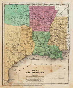
Sold2022Map No. 7. United StatesTitle: Map No. 7. United States Publication Date: 1854 Title: Map No. 7. United States Publisher: Daniel Burgess & Co. Height: 10.5 Width: 8.5 From Roswell C. Smith's Geography. Shows IN, OH, KY, TN aSee Sold Price
Sold2019Map of the Roman EmpireTitle: Map of the Roman Empire Publication Date: 1855 Cartographer: SMITH, ROSWELL C. Publisher: DANIEL BURGESS & CO. Size: 11.25Height - 18.75Width Brief Description: From Smith's atlas of modern andSee Sold Price
Sold2018U.S. Coast Survey 1853 Map of Aransas Pass, Texas"Reconnoissance of Aransas Pass Texas" Electrotype Map Published 1843-65, Washington for "Report of the Superintendent of the U.S. Coast Survey..." Published under the supervision and direction of AleSee Sold Price
Sold2018U.S. Coast Survey 1853 Map of Galveston Entrace, Texas"(Sketch I No. 3) Galveston Entrance Texas" Electrotype Map Published 1843-65, Washington for "Report of the Superintendent of the U.S. Coast Survey..." Published under the supervision and direction oSee Sold Price
Sold2017Fullarton: Antique Map of Texas & Indian Territory 1860Map: 1860 Fullarton Map of Texas (East/Central), Indian Territory, Louisiana and Arkansas -- United States North America According to Calvin Smith& Tanner . . . South Central Section. Comprising TexasSee Sold Price
Sold2019Map of Texas, Oklahoma and Indian TerritoryTitle: Map of Texas, Oklahoma and Indian Territory Publication Date: c1893 Cartographer: FISK & CO. Publisher: HUNT & EATON Size: 11.3Height - 9Width Description: From H.S. Smith's geography "The worlSee Sold Price
Sold2023Williamson, Lieut. R. S. 1856 Map. California, New Mexico, Texas, Mexico"United States & Mexican Boundary Survery" Lithograph Map Published 1853-61, Washington for "Reports of explorations and surveys, to ascertain the most practicable and economical route for a railroadSee Sold Price
Sold20211847 map showing east Texas/Indian TerritoryInteresting map of the southern U. S. in 1847. Map by Cady & Burgess from Roswell SmithÂ’s 1847 Quarto Atlas. Eastern portion of Texas shown along with most of Indian Territory. Also includes ArkanSee Sold Price
Sold2019J. Calvin Smith, "Colton's The United States ofJ. Calvin Smith, "Colton's The United States of America," 16 Maps comprising the wall map of the United States, 1853, paper mounted on linen, Each- H. - 16 in., W. - 20 1/4 in.See Sold Price
Sold2020North America with large independent TexasHeading: Author: Burgess, Daniel Title: Map of North America Designed to Accompany Smith's Geography for Schools Place Published: New York Publisher: Date Published: 1839 Description:See Sold Price
Sold2024Map of California, Utah, Oregon,New Mexico 1853Map of California, Utah, Oregon,New Mexico, Washington and Nebraska Hand colored. Map No 10 United States Cartographer: Jules Sherman Smith Publisher Daniel Burgess Dated: 1853<See Sold Price
2017Burgess: Antique Map of the United States, 18531853 Map of the United States with large Texas. Daniel Burgess. Delightful early school atlas map of the region. Shows counties, parishes, towns, rivers, populations, Indian Tribes, Court Houses, FortSee Sold Price
Sold2023VERY RARE WALL MAP OF THE CITY OF BANGOR,PENOBSCOT COUNTY, MAINE. 1853, Bangor, Maine. "Published Under the Patronage of the City Government Henry F. Walling, Civil Engineer, 81 Washington St. Boston 1853". "S.S. Smith, Publisher 17 West MarSee Sold Price
Sold2015WESTERN TEXAS SMITH & MILLER MINIATURE SADDLEWestern salesman's sample saddle, Smith and Miller Makers, Cisco Texas, marked, accompanied by stand, with age some loss, loose pieces and wear to leather, approx 14.5"h, 9lbs total Start Price: $50.0See Sold Price
Bonhams[SURTEES (ROBERT SMITH)] Collection of 5 sporting novels, FIRST EDITIONS IN THE ORIGINAL PARTS, ...£400
2 days LeftHolabird Western Americana CollectionsBartlett's Explorations ... Texas, NM, Calif., Sonora... 1854, 2 vols [181677]$200
4 days LeftEarly American History Auctions1853 Map, Basin of the St. Lawrence, by T. Keefer showing Natural + Artificial North American Routes$220
4 days LeftEarly American History Auctions1853 Map of Portion of British North America and Gulf of St. Lawrence, by Henry Perley$260
4 days LeftEarly American History Auctions1853 Specialized Map, Railroads in the United States in Operation and Progress... Treasury Deptment$200(1 bid)
2 hrs LeftJasper521853 Williamson Map of Tejon Pass, California -- Map and Profile of the Tejon Pass from explorations$55
2 hrs LeftJasper521853 Williamson Map of California's Tejon Pass Region -- Map and Profile of the Cañada de las$55
Jun 23Schilb Antiquarian Rare Books1848 Emory Military Reconnaissance 1ed California MAP Indians Texas New Mexico$3(3 bids)
4 days LeftSimpson Galleries, LLC.JULIUS BIEN (1826-1909) AN AMERICAN CIVIL WAR RECONNAISSANCE MAP, "Map of Texas and Part of New$100
2 days LeftAkiba GalleriesAntique Mast, Crowell, & Kirkpatrick Map Of Texas, California, & Nevada$25(1 bid)
Jun 13Swann Auction Galleries(NEW JERSEY.) William Kitchell; and Robert Pearsall Smith. Topographical Map of the State of New$600
2 days LeftAustin Auction GalleryJOHNE PARSLEY (D.2009) & PETER MCDOUGALL (B.1952) ART GLASS PAPERWEIGHT$800(4 bids)
2 days LeftAustin Auction GalleryPERTHSHIRE ENCASED GINGHAM CUT DOUBLE OVERLAY MAGNUM PAPERWEIGHT$550(4 bids)
2 days LeftAustin Auction Gallery(3) PERTHSHIRE CLOSE-PACKED MILLEFIORI & SILHOUETTE CANE PAPERWEIGHTS$375(3 bids)
2 days LeftAustin Auction GalleryRICK AYOTTE (B.1944) GLASS LAMPWORK ROSE BOUQUET MAGNUM PAPERWEIGHT$350(2 bids)
2 days LeftAustin Auction Gallery(2) PERTHSHIRE CLOSE-PACKED MILLEFIORI PEDESTAL PAPERWEIGHTS$350(2 bids)


![[SURTEES (ROBERT SMITH)] Collection of 5 sporting novels, FIRST EDITIONS IN THE ORIGINAL PARTS, ... (1 of 2)](https://p1.liveauctioneers.com/1043/319451/178359253_1_x.jpg?height=282&quality=70&version=1717515629)
![Bartlett's Explorations ... Texas, NM, Calif., Sonora... 1854, 2 vols [181677] (1 of 12)](https://p1.liveauctioneers.com/2699/331494/178785464_1_x.jpg?height=282&quality=70&version=1717189774)
![Jacob Monk 1853 Map of North America [173506] (1 of 11)](https://p1.liveauctioneers.com/2699/331495/178785775_1_x.jpg?height=282&quality=70&version=1717094933)


