Sold20231854-5 Parke Map of California from San Francisco to Los Angeles -- Map No. 1 From San Francisco BayDescriptionTitle: 1854-5 Parke Map of California from San Francisco to Los Angeles -- Map No. 1 From San Francisco Bay to the Plains of Los Angeles from Explorations and Surveys Made Under the DirectiSee Sold Price
Sold2017Geological Plan For Pacific Rail Road Surveys Map 18561855-6 Geological Plan For Pacific Rail Road Surveys -- Geological Plan Of The Coastal Range Of California From San Francisco To Los Angeles - No. 1. J Parke / T Antisell, 1856-7 Washington DC, 16.8 XSee Sold Price
Sold2023Reclus, Elisee 1893 Map. San Francisco Bay, California, USALithograph Map Published 1876-94, London for "The Universal Geography" by Elisee Reclus. Edited by A. H. Keane. Centre fold as published. Reverse side blank. Paper Size: 13.5 x 10.5 inch (34 x 27cm) GSee Sold Price
Sold20211950s Road map of Northern CaliforniaHeading: (California - Road maps) Author: Title: Road Map of California: Section 2 Place Published: San Francisco and Los Angeles Publisher:National Automobile Club Date Published: [c. 1950sSee Sold Price
Sold20231855 Williamson Map of San Francisco Bay to Oregon -- Map No. 1 From San Francisco Bay to theTitle: 1855 Williamson Map of San Francisco Bay to Oregon -- Map No. 1 From San Francisco Bay to the Northern Boundary of California from Explorations and Surveys Made Under the Direction of Hon. JeffSee Sold Price
Sold2022California Steamer & Railroad Passes [134776]Lot of 5. 1) Los Angeles Steamship Company. Two passes, issued in 1929 and 1931. Operated from LA to San Francisco, then added service to Hawaii. 2) California Western Railroad & Navigation Company. TSee Sold Price
Sold2016Map of California, 1899By Rand, McNally & Co., from Indexed Atlas Of The World. Chicago: 1899. Map features vignettes of Los Angeles, San Bernadino, Orange & San Diego Counties and seperate vignette of San Francisco area. DSee Sold Price
Sold20231940s San Francisco Bay Area Pictorial Map - San Francisco Bay Metropolitan Area - Attached to1940s San Francisco Bay Area Pictorial Map - San Francisco Bay Metropolitan Area - Attached to Poster Board from S.F. Economic Survey 1943 by S.F. Chamber of Commerce 31.5'' x 26''See Sold Price
Sold2023San Francisco & Los Angeles Road Mapsrated 9, 9"x4", both have good colorSee Sold Price
Sold2017ANTIQUE POLICE DEPARTMENT MUGSHOT BOOKING CARDS2Five (5) Bureau Of Identification, Department of Police, City of San Francisco/Los Angeles, California- antique criminal mug shot booking cards. Each one unique with personal description and mug shotsSee Sold Price
Sold2015Map of California by Mitchell, 1883Original lithograph published by Augustus Mitchell, 1883. Map features inset of San Francisco Bay & Vicinity. Dimensions: 27" L x 19.75" WSee Sold Price
Sold2017Map of San Francisco Bay, 1859Title: 1859 Map of San Francisco Bay Cartographer: US Coast Survey/ A. Bache Published: 1859, Washington DC Measurements: 23.2 x 39.2 in. Entrance to San Francisco Bay California. From a TrigonometricSee Sold Price
Sold20201910 McNally Map of San Francisco and California --Title/Content of Map: 1910 McNally Map of San Francisco and California -- Main portion of San Francisco [verso] California Date: 1910, Chicago Cartographer: Rand, McNallySize: 12.5 x 9.3 in. A very niSee Sold Price
Sold2021RINGGOLD - Bay of San Francisco Map 1850RINGGOLD, Cadwalader (1802-1867, surveyor). Chart of the Bay of San Pablo Straits of Carquines and part of the Bay of San Francisco California by ... Ringgold assisited by Simon F. Blunt ... ProjectedSee Sold Price
Sold2021Beautiful map of S.F. Bay Region 1873Heading: (California - San Francisco Bay Area) Author: California, State Geological Survey Title: Map of the Region Adjacent to the Bay of San Francisco... Place Published: [n.p.] Publisher: DateSee Sold Price
Sold2021Where not to park in San Francisco BayHeading: (California - San Francisco Bay) Author: Board of State Harbor Commissioners Title: Map showing forbidden anchorage, Bay of San Francisco, Mar. 1910 Place Published: No place Publisher:See Sold Price
Sold2018Map of Bay Area ports and facilitiesHeading: (California - San Francisco Bay Area) Author: Rand, McNally & Co. Title: Ports and Facilities on San Francisco Bay, and Tributary Waters Place Published: San Francisco Publisher: Date PuSee Sold Price
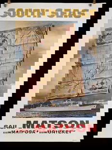
Sold2023Matson SS Mariposa South Seas Lithograph Travel Cruise PosterMatson Lines SS Mariposa SS Monterey South Seas Treasure Map Poster. Reads Matson's Treasure Route Through All The South seas, San Francisco, Los Angeles, Hawaii, Samoa, Fiji, Sydney, Auckland, TahitiSee Sold Price
Sold2024Matson SS Mariposa South Seas Lithograph Travel Cruise PosterMatson Lines SS Mariposa SS Monterey South Seas Treasure Map Poster. Reads Matson's Treasure Route Through All The South seas, San Francisco, Los Angeles, Hawaii, Samoa, Fiji, Sydney, Auckland, TahitiSee Sold Price
Sold2020Rare pictorial map of Oakland and S.F. BayHeading: (California - Oakland, San Francisco, etc.) Author: Lundy, Fred Title: San Francisco Bay. (with) part of San Francisco and Oakland Place Published: Oakland, CA Publisher:Tribune Publishing CoSee Sold Price
Sold2015Map of California, 1895Original map published from Indexed Atlas of the World by Rand McNally, 1895. Map features insets of San Francisco area & San Diego county. Unframed. Dimensions: 32" L x 25.5" WSee Sold Price
Sold20201888 San Francisco souvenir w/folding mapHeading: (California - San Francisco) Author: Title: Historical Souvenir of San Francisco, Cal. With Views of Prominent Buildings, the Bay, Islands, Etc. Place Published: San Francisco Publisher:C. PSee Sold Price
Sold2021Antique California Maps c1872-1896 (Lot of 3) [31975]1) 1896 City of San Francisco, 2000 feet to the inch, printed on newsprint, separated in two pieces at the center fold. Very detailed, some penciled notes in the top right. Map includes concentric cirSee Sold Price
Sold2019Samuel Augustus Mitchell (1790-1868), " County Map ofSamuel Augustus Mitchell (1790-1868), " County Map of California with an inset of San Francisco and the Settlements of Great Salt Lake Country, Utah," 1867, hand colored, H.-15 1/8 in., W.-12 1/2 in.See Sold Price
Jun 12Jasper52Amér. Sep. Nouvelle Californie #46. Northern California. VANDERMAELEN 1827 map$260
1 day LeftHolabird Western Americana CollectionsClassic Pioneer Guides to California, 1845-9 Reprints [183985]$75
1 day LeftHolabird Western Americana CollectionsLe Breton Original Lithograph: San Francisco 1854 [180768]$300
3 days LeftFive Star AuctionsAn Exquisite Monumental 19th C. Italian Ignace Spiridon Framed Oil On Canvas Painting$50,000
1 day LeftHolabird Western Americana CollectionsEarly California Pre-Gold Rush Books (2) 1959-68 [182293]$75
2 days LeftHolabird Western Americana CollectionsMaps of San Francisco Bay 1851, 1859 (3) [180180]$150
1 day LeftHolabird Western Americana CollectionsFont's Complete Diary / Founding of San Francisco 1933 [181866]$75
6 days LeftJohn Moran Auctioneers, Inc.KAWS, Barry (Twist) McGee, Margaret Kilgallen, Shepard Fairey, Ruby Rose Neri, Jared (Geso) Costa,$7,500


![California Steamer & Railroad Passes [134776]: Lot of 5. 1) Los Angeles Steamship Company. Two passes, issued in 1929 and 1931. Operated from LA to San Francisco, then added service to Hawaii. 2) California Western Railroad & Navigation Company. T](https://p1.liveauctioneers.com/2699/237271/122972385_1_x.jpg?height=310&quality=70&version=1645234681)


![1910 McNally Map of San Francisco and California --: Title/Content of Map: 1910 McNally Map of San Francisco and California -- Main portion of San Francisco [verso] California Date: 1910, Chicago Cartographer: Rand, McNallySize: 12.5 x 9.3 in. A very ni](https://p1.liveauctioneers.com/5584/160636/81086802_1_x.jpg?height=310&quality=70&version=1580865551)

![Beautiful map of S.F. Bay Region 1873: Heading: (California - San Francisco Bay Area) Author: California, State Geological Survey Title: Map of the Region Adjacent to the Bay of San Francisco... Place Published: [n.p.] Publisher: Date](https://p1.liveauctioneers.com/642/204898/103986346_1_x.jpg?height=310&quality=70&version=1621652446)


![Antique California Maps c1872-1896 (Lot of 3) [31975]: 1) 1896 City of San Francisco, 2000 feet to the inch, printed on newsprint, separated in two pieces at the center fold. Very detailed, some penciled notes in the top right. Map includes concentric cir](https://p1.liveauctioneers.com/2699/202326/102449099_1_x.jpg?height=310&quality=70&version=1619652794)


![Classic Pioneer Guides to California, 1845-9 Reprints [183985] (1 of 4)](https://p1.liveauctioneers.com/2699/331494/178785426_1_x.jpg?height=282&quality=70&version=1717094654)


![Le Breton Original Lithograph: San Francisco 1854 [180768] (1 of 2)](https://p1.liveauctioneers.com/2699/331494/178785160_1_x.jpg?height=282&quality=70&version=1717094654)

![Early California Pre-Gold Rush Books (2) 1959-68 [182293] (1 of 7)](https://p1.liveauctioneers.com/2699/331494/178785430_1_x.jpg?height=282&quality=70&version=1717094654)
![Maps of San Francisco Bay 1851, 1859 (3) [180180] (1 of 3)](https://p1.liveauctioneers.com/2699/331495/178785789_1_x.jpg?height=282&quality=70&version=1717094933)
![Font's Complete Diary / Founding of San Francisco 1933 [181866] (1 of 8)](https://p1.liveauctioneers.com/2699/331494/178785432_1_x.jpg?height=282&quality=70&version=1717094654)
![Encased Penny Collection [182760] (1 of 3)](https://p1.liveauctioneers.com/2699/331499/178846328_1_x.jpg?height=282&quality=70&version=1717095214)


