Sold20231861. World in Double Hemisphere Projection. By Johnson and BrowningTitle: 1861. World in Double Hemisphere Projection. By Johnson and Browning Date/Period: 1861 Materials: Steel engraved Size: 26 x 18” 1861, by Johnson and Browning. From ‘New IllustratedSee Sold Price
Sold2022Polar regions in two double hemisphere projections.Title: Polar regions in two double hemisphere projections. 1862 by Johnson and Ward Date/Period: 1862 Materials: Steel plate engraved. Size: 19" x 14" 1862 from 'Johnson's New Illustrated Family AtlasSee Sold Price
Sold2021Double hemisphere world map with additionalTitle: Double hemisphere world map with additional projections. 1752 by Homann Heirs Date/Period: 1762 Materials: Copperplate engraved Size: 24 x 20 1/2 1762, by J. B. Homann & Homann Heirs, from "AtlSee Sold Price
Sold20231861. Worlds plants, rain and weather patterns. By Johnson and BrowningTitle: 1861. Worlds plants, rain and weather patterns. By Johnson and Browning Date/Period: 1861 Materials: Steel engraved Size: 18x13” 1861, by Johnson and Browning. From ‘New IllustratedSee Sold Price
Sold20231861. Worlds animals types and industrial production. By Johnson and BrowningTitle: 1861. Worlds animals types and industrial production. By Johnson and Browning Date/Period: 1861 Materials: Steel engraved Size: 18x13” A small insert to attempt to show bird types as wellSee Sold Price
Sold20231861. World’s land types, tides, ocean currents. By Johnson and BrowningTitle: 1861. World’s land types, tides, ocean currents. By Johnson and Browning Date/Period: 1861 Materials: Steel engraved Size: 18x13” 1861, by Johnson and Browning. From ‘New IlluSee Sold Price
Sold20231866 Johnson's World on Mercator's ProjectionTitle: 1866 Johnson's World on Mercator's Projection Cartographer: Johnson and Ward Year / Place: 1866, New York Map Dimension (in.): 17 X 23 in. This is a highly detailed double-page map of the WorldSee Sold Price
Sold2017Johnson: Map of the World On Mercator's ProjectionMap Title: Map of the World On Mercator's Projection Publisher: Johnson And Ward, Alvin Jewett Johnson Publishing Date: 1861 Size: Double Folio - 15.25 x 24.00 inches Large, Handsome world map showingSee Sold Price
Sold2019World double HemisphereReserve Reduced! Title/Content of Map: World double Hemisphere Date: 1598/99. Cartographer: Ruscelli Size: 11x9” Provenance: Venice. Reserve: $800.00 Jasper52 negotiates the lowest reserves so biddeSee Sold Price
Sold20181782 A New Map of the World1782 "A New Map of the World", double hemisphere map published by Harrison and Co., London, 1782. Folding map, measures 17 x 10". Fine, mild discoloration. Reserve: $80.00 Shipping: Domestic: Flat-ratSee Sold Price
Sold20191782 A New Map of the World1782 “A New Map of the World”, double hemisphere map published by Harrison and Co., London, 1782. Folding map, measures 17 x 10”. Fine, mild discoloration. Reserve: $80.00 Shipping: Domestic: FlSee Sold Price
Sold20191784 Two Double Hemisphere Maps ProjectionsTwo double hemisphere projections, one being a Stereographic map and the other with an Orthographic Projection, both published by Harrison and Co, London, 1784. Each Fine, measures 10 x 8”. Reserve:See Sold Price
2022Blaeu, Johannes (Netherlands, 1596-1673) "The New World Map" Double Hemisphere World Map C. 1664Nova et Accuratissima Totius Terrarum Orbis Tabula Translated "The New World Map", Hand Colored w/ Elaborately Decorated Spandrels.   Sight View 16" x 21-1/2", Overall View 21" x 25-1/2"See Sold Price
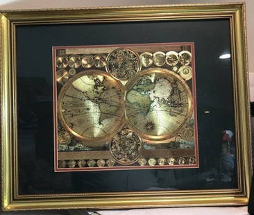
Sold2023Vintage GOLD FOIL WORLD MAP DOUBLE HEMISPHERE 25x31 FRAMED Wall HangingVintage Huge GOLD FOIL WORLD MAP DOUBLE HEMISPHERE 25x31 FRAMED Wall Hanging in a Gorgeous Gold Leaf Frame in VG Condition. Local Pickup Only in Berlin NJ 08009 or UPS Store Shipping Paid for by the WSee Sold Price
Sold2020World. In double Hemispheres. 1850 by ThomasTitle: World. In double Hemispheres. 1850 by Thomas Date/Period: c1850. Materials: Hand colored steel engraved Size: 16 1/2 x 13 1/2 inches. c1850 by Thomas, Cowperthwait & Co. From 'A New Universal ASee Sold Price
Sold2021JOHNSON & COLTON NEW ILLUSTRATED FAMILY ATLAS 1861Johnson's New Illustrated steel plate family atlas with descriptions. Compiled Drawn and Engraved under the supervision of J.H. Colton and A. J. Johnson 1861 Johnson and Browning New YorkSee Sold Price
Sold2024Scarce Georgia-Alabama Civil War-era RR map by Johnson & Browning, 1861Johnson’s Georgia and Alabama from the scarce 1861 edition of Johnson’s Family Atlas published shortly after the outbreak of the war in 1861 by Johnson & Browning. Shows network of railroaSee Sold Price
Sold20201746 Homann Double Hemisphere World Map -- PlaniglobiiTitle/Content of Map: 1746 Homann Double Hemisphere World Map -- Planiglobii Terrestris Mappa Universalis utrumque Hemisphaerium Orient et Occidentale Repraesentans ex IV. Mappis Generalibus ... / MapSee Sold Price
2022Seutter, Matthaus (Germany, 1678-1757) Double Hemisphere World Map C. 1730Sight View  19-1/2" x 23", Overall View 22" x 25", Hand Colored "Quibus Addita, Pro Mutatione Horizontis Differentes Sphara Po Sitiones Earumque Convenientia Et RelaSee Sold Price
Sold2019Double hemisphere world map by Ruscelli, 1561Heading: Author: Ruscelli, Girolamo Title: Orbis Descriptio Place Published: Venice Publisher: Date Published: 1561-[1574?] Description: Double-hemisphere copper-engraved wSee Sold Price
Sold2018Extremely Rare world map in double HemisphereTitle/Content of Map: Extremely Rare world map in double Hemisphere projection Date: 1717 Size: 7.6x10.6†by Feuille published in 1717, Amsterdam. With California as a island. from one of the mostSee Sold Price
Sold20241747 Lat Double Hemisphere World Map -- De Nieuwe en Ouden, Oppervlakke en Doorzigtkundige AardryksTitle: 1747 Lat Double Hemisphere World Map -- De Nieuwe en Ouden, Oppervlakke en Doorzigtkundige Aardryks Bollen Getekent en Uitgegeven tot Almelo by Jacobus Keizer en te Deventer by Ian De Lat CartoSee Sold Price
Sold2021Double Hemisphere world map by Bonne/ Raynal 1780Title: Double Hemisphere world map by Bonne/ Raynal 1780 Date/Period: 1780 Materials: Copperplate engraved Size: 17 1/2 x 9 3/4”. Maps shows the North American west empty, misshaped Alaska, theSee Sold Price
Sold2023Texas. 1861 by Johnson and BrowningTitle: Texas. 1861 by Johnson and Browning Date/Period: 1861 Materials: Steel engraved Size: 26 x 18” With inserts of the northern region, Galveston Bay, and a lake. 1861, by Johnson and BrowninSee Sold Price
4 days LeftWorthington Galleries19th c. Hemisphere World Map, Hohen und Tiefen der Erde in Lambert’s Zenithal-Projection von$10
4 days LeftWorthington GalleriesAntique Hand-colored Hemisphere Map Mappemonde Revue par E. Cortambert 1864$25
26 mins LeftJasper521833 Woodbridge World Map -- Map of the World Adapted to Woodbridge's Geography$40
Jun 13Swann Auction GalleriesRUSCELLI, GIROLAMO. Group of 26 double-page engraved maps from La Geografia di Claudio Tolomeo$1,500
247 Lots AwayJasper521761 NEW DICTIONARY OF TRADE & COMMERCE R. ROLT antique FOLIO ILLUSTRATED w/MAPS$440
3 days LeftHolabird Western Americana CollectionsMap of The World in Hemispheres, c1850's [180166]$100
Jun 13Swann Auction Galleries(AMERICAS.) Giovanni Battista Ramusio. Universale Della Parte del Mondo Nuovamente Ritrovata.$1,900
JG AutographsJohn F. Kennedy Original 10 x 8" Cecil Stoughton Funeral Photograph at Cemetery with World Leaders$35(1 bid)
3 days LeftFreeman's | Hindman[MAP]. ORTELIUS, Abraham. Americae Sive Novi Orbis, Nova Descriptio. 1573.$1,000(1 bid)


![Double hemisphere world map by Ruscelli, 1561: Heading: Author: Ruscelli, Girolamo Title: Orbis Descriptio Place Published: Venice Publisher: Date Published: 1561-[1574?] Description: Double-hemisphere copper-engraved w](https://p1.liveauctioneers.com/642/139321/70635504_1_x.jpg?height=310&quality=70&version=1554323736)


![Map of The World in Hemispheres, c1850's [180166] (1 of 1)](https://p1.liveauctioneers.com/2699/331495/178785785_1_x.jpg?height=282&quality=70&version=1717094933)


![[MAP]. ORTELIUS, Abraham. Americae Sive Novi Orbis, Nova Descriptio. 1573. (1 of 2)](https://p1.liveauctioneers.com/197/329395/177650534_1_x.jpg?height=282&quality=70&version=1715364962)
![[MAP]. ORTELIUS, Abraham. Aevi Veteris, Typus Geographicus. 1601. (1 of 3)](https://p1.liveauctioneers.com/197/329395/177650532_1_x.jpg?height=282&quality=70&version=1715364962)

![[ROMANTIC POETS]. A group of 11 works, including: (1 of 1)](https://p1.liveauctioneers.com/197/329405/177652683_1_x.jpg?height=282&quality=70&version=1715364568)


