Sold2022Scarce Johnson's Missouri & Kansas map during CivilLarge double-page map of these two states of great importance during the Civil War. One of Johnson and Ward’s more decorative issues, this map offers a fascinating snapshot of these two hotly cSee Sold Price
Sold2019U S Coast Survey 1896 Map. Missouri & Kansas"Sketch showing Route Line of Spirit Levels" Lithograph Map Published 1896, Washington for "U.S. Coast and Geodetic Survey" Folds as issued. Rare. Paper Size: 16 x 11.5 inch (40 x 29cm) Good ConditionSee Sold Price
Sold2020U S Coast Survey 1896 Map. Missouri & Kansas"Sketch showing Route Line of Spirit Levels from Jefferson City Mo. To Holliday, Kans" Lithograph Map Published 1896, Washington for "U.S. Coast and Geodetic Survey" Folds as issued. Rare. Paper Size:See Sold Price
Sold2017Johnson: Antique Map of Missouri & Kansas, 1868Title/Content of Map: Missouri & Kansas by Johnson Date Printed: 1868 Cartographer: A.J. Johnson Material/Medium: Paper Size: 18" x 24" Hand colored steel engraved Map. From Johnson's New IllustratedSee Sold Price
Sold2022Scarce map of Indian Terr., Kansas, Missouri, IllinoisScarce map of a cross section of American states and hand-colored by county at the time of publishing. Shows Oklahoma Territory when it was inhabited mostly by Native American tribes. Shows forts, raiSee Sold Price
Sold20231861 Johnson Map of Missouri and Kansas -- Johnson's Missouri and KansasTitle: 1861 Johnson Map of Missouri and Kansas -- Johnson's Missouri and Kansas Cartographer: Johnson & Ward Year / Place: 1861, New York Map Dimension (in.): 17.1 X 23.1 in. This is an attractive douSee Sold Price
Sold20221866 Johnson Map of Missouri and Kansas -- Johnson's Missouri and KansasTitle: 1866 Johnson Map of Missouri and Kansas -- Johnson's Missouri and Kansas Cartographer: Johnson and Ward Year / Place: 1866, New York Map Dimension (in.): 17.1 X 23.1 in. This excellent double-pSee Sold Price
Sold20201865 Johnson Map of Missouri and Kansas -- Johnson'sTitle/Content of Map: 1865 Johnson Map of Missouri and Kansas -- Johnson's Missouri and Kansas Cartographer: A Johnson Year/Place: 1865, New York Size: 17.1 X 23.1 in. This double-page map shows all oSee Sold Price
Sold2022(MISSOURI.) Samuel N. Gaston. New Railroad and Township Map of Missouri and Eastern Kansas.(MISSOURI.) Samuel N. Gaston. New Railroad and Township Map of Missouri and Eastern Kansas. Large lithographed pocket map. 21x29 inches overall, folding into publisher's 12mo format gilt and blind staSee Sold Price
Sold20221862 John Pope Civil War Map Missouri BowenMap showing the System of Rebel Fortifications on the Mississippi River at Island No. 10 and New Madrid also The Operations of the U.S. Forces under General John Pope Against These Positions. "Bowen &See Sold Price
Sold2017Johnson: Map of Nebraska Dakota Colorado Kansas, 1862Map: Johnson's Nebraska, Dakota, Colorado & Kansas Maker: Johnson & Ward Date: 1862 Size: 12.5 x 15.5 inches Condition: Couple of very light, tiny spots in image. Stains in margin. Two spots in frame.See Sold Price
Sold2019Scarce 1862 Neb/Dak/Col/Kans - Johnson & WardReserve Reduced! One of the rarest and most desirable states of Johnson's Dakota, Nebraska and Kansas map. In this example Nebraska is drawn with a long panhandle extending from Iowa all the way to FrSee Sold Price
Sold2020Missouri, Kansas & Texas Railway and Connections.Publication Date: c1870 Title: Missouri, Kansas & Texas Railway and Connections. Cartographer: RAND, MCNALLY & CO. Publisher: RAND, MCNALLY & CO. Height: 8.25 Width: 11.5 Book illustration map possiblSee Sold Price
Sold2023Map of Kansas City, Missouri and Kansas City, KansasPublication Date: 1889 Title: Map of Kansas City, Missouri and Kansas City, Kansas Cartographer: CRAM, GEO. F. Publisher: CRAM, GEO. F. Height: 9.6 Width: 11.6 Map showing Kansas City, MO with easternSee Sold Price
Sold2018Big map oriental United States, 1875, steel etching,Very beautiful map of oriental United States (Louisiana, Mississipi, Alabama, Georgia, Florida, South Carolina, North Carolina, Tennessee, Arkansas, Virginia, Kentucky, Missouri, Kansas, Nebraska, IowSee Sold Price
Sold2023Map of Kansas City, Missouri and Kansas City, Kansas (and) St. LouisTitle: Map of Kansas City, Missouri and Kansas City, Kansas (and) St. Louis Cartographer: George F. Cram Publisher: George F. Cram Date: 1892 Description: "Kansas City" - Map with streets named, railrSee Sold Price
Sold20171862 Johnson’s Nebraska, Dakota, Colorado & Kansas1862 Johnson’s Nebraska, Dakota, Colorado & Kansas. Johnson & Ward. One of the rarest and most desirable states of the Johnson's Dakota, Nebraska and Kansas map. Nebraska drawn with long panhandle eSee Sold Price
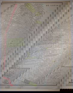
Sold2023St. Louis/Map of Kansas City, Missouri and Kansas City, KansasPublication Date: 1892 Title: St. Louis/Map of Kansas City, Missouri and Kansas City, Kansas Cartographer: George F. Cram Publisher: George F. Cram Height: 13.5 Width: 10 "St. Louis" - Extremely detaiSee Sold Price
Sold2018Johnson & Ward: Kansas & Missouri, 1864The scarce and highly detailed map of the pivotal states of Missouri and Kansas near the end of the Civil War, with western Kansas still largely unorganized. In addition to showing major transcontinenSee Sold Price
Sold2022Kansas City, Missouri Wells Fargo Express Letterhead [151814]1888. Map of Wells Fargo from Ocean to Ocean. ET Campbell superintendent Kansas Division. Sent by Uncle John to niece Angie. He will be back in New Mexico soon!Date: 1888Country (if not USA): State: MSee Sold Price
Sold2019Nine (9) Augustus Mitchell MapsCollection of late 19th century United States STATE maps including Minnesota, Iowa and Missouri, State of Maine , Illinois-Missouri-Iowa-Nebraska-and Kansas on one, Two Georgia and Alabama, ConnecticuSee Sold Price
Sold2022Reed's Guide to the Kansas Gold Region; Reprint [151390]1959 reprint of Reed's Guide to the Kansas Gold Region, With a Map Embracing the Northern and Southern Routes, from the Missouri River to Pike's Peak. Originally published by J.H. Colton in 1859. TherSee Sold Price
Sold20221862 Johnson Map of Nebraska, Dakota, Colorado andTitle: 1862 Johnson Map of Nebraska, Dakota, Colorado and Kansas -- Johnson's Nebraska, Dakota, Colorado, & Kansas. Cartographer: Johnson and Ward Date/Place: 1862, New York Dimensions: 12.4 X 15.4 DeSee Sold Price
Sold2016Large 1862 US Civil War Wall MapColton's Map of the Southern States. Including Maryland, Delaware, Virginia, Kentucky, Tennessee, Missouri, North Carolina, South Carolina, Georgia, Alabama, Mississippi, Arkansas, Louisiana, Texas ..See Sold Price
Jun 12Jasper52Amér. Sep. Parties des États-Unis #49. Missouri Illinois. VANDERMAELEN 1827 map$260
2 days LeftHolabird Western Americana CollectionsMissouri, Kansas & Texas RWY Passes, 3 Different [180390]$50
2 days LeftHolabird Western Americana CollectionsMissouri, Kansas & Texas RWY Passes, 2 Different [180391]$50
2 days LeftHolabird Western Americana CollectionsMissouri, Kansas & Texas LinesPasses 2 Different [180392]$50
Jun 29JM Hobby Supply and Railroad Artifact AuctionsMissouri-Kansas-Texas RR Handlan Large Pot Utility Lantern$25(2 bids)
Jun 29JM Hobby Supply and Railroad Artifact AuctionsMissouri-Kansas-Texas RR Handlan Switch Lamp$100(1 bid)
Jun 29JM Hobby Supply and Railroad Artifact AuctionsMissouri-Kansas-Texas RR Handlan Switchmans Lantern$80
4 days LeftWhite Knight Auction, IncThomas Hart Benton 'Back From The Fields', 1945 Hand Signed Limited Edition$2,000
2 days LeftHolabird Western Americana CollectionsGalveston, Livingston & Henderson RR pass, 1880 [179575]$50


![Kansas City, Missouri Wells Fargo Express Letterhead [151814]: 1888. Map of Wells Fargo from Ocean to Ocean. ET Campbell superintendent Kansas Division. Sent by Uncle John to niece Angie. He will be back in New Mexico soon!Date: 1888Country (if not USA): State: M](https://p1.liveauctioneers.com/2699/258185/134287687_1_x.jpg?height=310&quality=70&version=1660347389)

![Reed's Guide to the Kansas Gold Region; Reprint [151390]: 1959 reprint of Reed's Guide to the Kansas Gold Region, With a Map Embracing the Northern and Southern Routes, from the Missouri River to Pike's Peak. Originally published by J.H. Colton in 1859. Ther](https://p1.liveauctioneers.com/2699/258185/134287651_1_x.jpg?height=310&quality=70&version=1660347389)


![Nord America, Westindien, 1862 Map [179350] (1 of 4)](https://p1.liveauctioneers.com/2699/331495/178785792_1_x.jpg?height=282&quality=70&version=1717094933)

![Missouri, Kansas & Texas RWY Passes, 3 Different [180390] (1 of 2)](https://p1.liveauctioneers.com/2699/331495/178786033_1_x.jpg?height=282&quality=70&version=1717094933)
![Missouri, Kansas & Texas RWY Passes, 2 Different [180391] (1 of 2)](https://p1.liveauctioneers.com/2699/331495/178786032_1_x.jpg?height=282&quality=70&version=1717094933)
![Missouri, Kansas & Texas LinesPasses 2 Different [180392] (1 of 2)](https://p1.liveauctioneers.com/2699/331495/178786031_1_x.jpg?height=282&quality=70&version=1717094933)


![Galveston, Livingston & Henderson RR pass, 1880 [179575] (1 of 2)](https://p1.liveauctioneers.com/2699/331495/178785956_1_x.jpg?height=282&quality=70&version=1717094933)