Sold2022Scarce map of Indian Terr., Kansas, Missouri, IllinoisScarce map of a cross section of American states and hand-colored by county at the time of publishing. Shows Oklahoma Territory when it was inhabited mostly by Native American tribes. Shows forts, raiSee Sold Price
Sold2022Great Colton map of MissouriExcellent 1855 first edition example of Colton's map of Missouri. Covers the entire state as well as adjacent parts of Illinois and Kansas. In Kansas, various Indian tribes are noted including the CheSee Sold Price
Sold2022Scarce Johnson's Missouri & Kansas map during CivilLarge double-page map of these two states of great importance during the Civil War. One of Johnson and Ward’s more decorative issues, this map offers a fascinating snapshot of these two hotly cSee Sold Price
Sold2018Johnson & Ward: Kansas & Missouri, 1864The scarce and highly detailed map of the pivotal states of Missouri and Kansas near the end of the Civil War, with western Kansas still largely unorganized. In addition to showing major transcontinenSee Sold Price
Sold2019Nine (9) Augustus Mitchell MapsCollection of late 19th century United States STATE maps including Minnesota, Iowa and Missouri, State of Maine , Illinois-Missouri-Iowa-Nebraska-and Kansas on one, Two Georgia and Alabama, ConnecticuSee Sold Price
Sold20221st ed. near pristine McNally map of Texas & Ind. Terr., 1881Highly detailed and scarce large format railroad map, one of the best of the period. Rand, McNally & Co.’s Texas and Indian Territory, dated 1881 (first edition). This great map depicts railroadSee Sold Price
Sold2021Scarce map of Indian Territory, 1886Most likely the final map of Indian Territory produced by the Colton firm. Map is colored by Indian Nations, and shows a massive Cheyennes and Arapahoes Nation at the top. Over two dozen Native AmericSee Sold Price
Sold2023Scarce and sharp 1833 map of Missouri, Anthony FinleyExtremely scarce map of Missouri from Anthony Finley’s 1833 New General Atlas. Osage, Kickapoo, Delaware and Shawnee tribes shown occupying most of the Ozark Mountains in the lower left quarterSee Sold Price
Sold2022Set of Three MapsSet of Three Maps, to include geographical, statistical, and historical maps of Missouri, Illinois, and Mississippi, plate numbers 34, 33, and 29, hand colored copper engravings, having information teSee Sold Price
Sold2021[NATIVE AMERICANS]. Geronimo Carving Buffalo Meat for[NATIVE AMERICANS]. Geronimo Carving Buffalo Meat for His Indians. Kansas City, Missouri: Martin Post Card Co., [ca 1907-1911].5 3/8 x 3 1/2 in. real photo postcard. Title and copyright information wrSee Sold Price
Sold2021Map of Indian Territory & KansasMap of Indian Territory Combined with Map of Kansas on Verso Color Map Dated: 19th century Dimensions: 10 x 6 1/2" Condition Report Good. TextSee Sold Price
Sold2021Map of Texan, Indian Terr. & N. Mex., 1868Terrific post-Civil War school atlas map of the region. Map drawn by Oliver J. Stuart. Numerous Indian tribes, counties, towns, forts, rivers, and other details. Inset of Galveston area. Full originalSee Sold Price
Sold2022Map of Texas, Indian Terr., Mississippi, etc.- OlneyNice hand-colored school atlas map of the near Southwest. “No. 8 Mississippi, Arkansas, Louisiana, Texas, Indian Territory.” From Olney’s 1849 school atlas. Clean with a tiny spot iSee Sold Price
Sold2020Scarce pocket map of Missouri, 1855Title: Scarce pocket map of Missouri, 1855 Description: Beautiful and scarce pocket map of Missouri, published 1855 by J. H. Colton. Hand-colored by county. Toning where glued into pocket. Three tinySee Sold Price
Sold2022Uncommon map of Oklahoma & Indian Terr., 1897Unusual wax engraved map of Oklahoma Territory/Indian Territory ten years before the region achieved statehood. Numerous Indian nations located throughout. Shows railroads with routes named, towns, riSee Sold Price
Sold2023Map of Kansas City, Missouri and Kansas City, KansasPublication Date: 1889 Title: Map of Kansas City, Missouri and Kansas City, Kansas Cartographer: CRAM, GEO. F. Publisher: CRAM, GEO. F. Height: 9.6 Width: 11.6 Map showing Kansas City, MO with easternSee Sold Price
Sold2023Map of Kansas City, Missouri and Kansas City, Kansas (and) St. LouisTitle: Map of Kansas City, Missouri and Kansas City, Kansas (and) St. Louis Cartographer: George F. Cram Publisher: George F. Cram Date: 1892 Description: "Kansas City" - Map with streets named, railrSee Sold Price
Sold2019U S Coast Survey 1896 Map. Missouri & Kansas"Sketch showing Route Line of Spirit Levels" Lithograph Map Published 1896, Washington for "U.S. Coast and Geodetic Survey" Folds as issued. Rare. Paper Size: 16 x 11.5 inch (40 x 29cm) Good ConditionSee Sold Price
Sold2020U S Coast Survey 1896 Map. Missouri & Kansas"Sketch showing Route Line of Spirit Levels from Jefferson City Mo. To Holliday, Kans" Lithograph Map Published 1896, Washington for "U.S. Coast and Geodetic Survey" Folds as issued. Rare. Paper Size:See Sold Price
Sold2021Group of 3 Vintage MapsOhio/Indiana map (1921) measures 26.5 x 22.5 inches, Illinois/Missouri map (1921) measures 29 x 23.5 inches, Military map (1861) measures 29.5 x 23 inches with mat included. All maps are on heavy stocSee Sold Price
Sold2020Alex Yaworski (IL,MO,KS,Russia,1907-1997) watercolor onARTIST: Alex F. Yaworski (Illinois, Missouri, Kansas, Russia, 1907 - 1997) NAME: Landscape Long Grove, IL MEDIUM: watercolor on paper CONDITION: Excellent. Framed under glass. SIGHT SIZE: 14 x 20 inchSee Sold Price
Sold2021Texas, Oklahoma, Indian Terr. 1900Title/Content of Map: Texas, Oklahoma, Indian Terr. 1900 Date Printed: 1900 Material/Medium: paper Size: approx. 21x13 inches. . Additional Info: Mast, Crowell & Kirkpatrick - 2 folds, edges repairedSee Sold Price
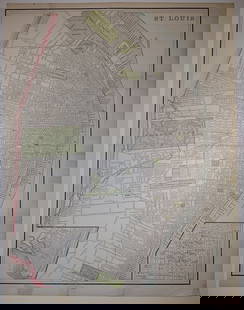
Sold2023St. Louis/Map of Kansas City, Missouri and Kansas City, KansasPublication Date: 1892 Title: St. Louis/Map of Kansas City, Missouri and Kansas City, Kansas Cartographer: George F. Cram Publisher: George F. Cram Height: 13.5 Width: 10 "St. Louis" - Extremely detaiSee Sold Price
Sold2017Outlaws On Horseback... Bands of Bank and Train RobbersOutlaws On Horseback... Bands of Bank and Train Robbers... Terrorized the Prairie Towns of Missouri, Kansas, Indian Territory, and Oklahoma for Half a Century. Drago, Harry. Bramhall House. Reprint. OSee Sold Price
5 days LeftForum AuctionsIndia.- Phillimore (Colonel R. H.) Historical Records of the Survey of India, 4 vol. only (of 5),£1,000
Jun 01Link Auction GalleriesKenneth Pauling Riley, Arizona, Kansas, Missouri (1919-2015), Trappers along a River, 1981, oil on$4,000
Jun 01Link Auction GalleriesEugene Higgins, New York, Connecticut, Kansas, Missouri (1874-1958), Children with a Goat, pastel on$150(1 bid)
6 days LeftFreeman's | Hindman[TRANSPORTATION - RAILROAD]. Missouri, Kansas, & Texas Railway display featuring photographs of San$500
Jun 01Link Auction GalleriesJoseph G. Brunn, Missouri / Kansas (fl. 1890s), Stream with distant mountain, watercolor on paper$50
Jun 29JM Hobby Supply and Railroad Artifact AuctionsMissouri-Kansas-Texas RR Handlan Switch Lamp$100(1 bid)


![[NATIVE AMERICANS]. Geronimo Carving Buffalo Meat for: [NATIVE AMERICANS]. Geronimo Carving Buffalo Meat for His Indians. Kansas City, Missouri: Martin Post Card Co., [ca 1907-1911].5 3/8 x 3 1/2 in. real photo postcard. Title and copyright information wr](https://p1.liveauctioneers.com/197/214395/109692090_1_x.jpg?height=310&quality=70&version=1628790729)


![[TRANSPORTATION - RAILROAD]. Missouri, Kansas, & Texas Railway display featuring photographs of San (1 of 4)](https://p1.liveauctioneers.com/197/329785/177758611_1_x.jpg?height=282&quality=70&version=1715625218)


