Sold20241872 Holy BIBLE & Hitchcock Analysis Gruden Concordance Theology MAPS Holy Land1872 Holy BIBLE & Hitchcock Analysis Gruden Concordance Theology MAPS Holy Land A rare, 19th-century book of systematic theology published by the Johnson in New York. This edition of Hitchcocks CompleSee Sold Price
Sold20191870 Holy BIBLE & Hitchcock Complete Analysis Gruden1870 Holy BIBLE & Hitchcock Complete Analysis Gruden Concordance Theology A rare, 19th-century book of systematic theology published by the Johnson in New York. This edition of ‘Hitchcock’s compleSee Sold Price
Sold20201870 Holy BIBLE Hitchcock Complete Analysis Gruden1870 Holy BIBLE Hitchcock Complete Analysis Gruden Concordance Theology A rare, 19th-century book of systematic theology published by the Johnson in New York. This edition of ‘Hitchcock’s CompleteSee Sold Price
Sold20201871 Holy BIBLE & Hitchcock Complete Analysis Gruden1871 Holy BIBLE & Hitchcock Complete Analysis Gruden Concordance Theology A rare, 19th-century book of systematic theology published by the Johnson in New York. This edition of ‘Hitchcock’s compleSee Sold Price
Sold20191871 Holy BIBLE & Hitchcock Complete Analysis Gruden1871 Holy BIBLE & Hitchcock Complete Analysis Gruden Concordance Theology A rare, 19th-century book of systematic theology published by the Johnson in New York. This edition of ‘Hitchcock’s compleSee Sold Price
Sold20231869 Holy Bible + Analysis Commentary Concordance MAP Theology Doctrine West1869 Holy Bible + Analysis Commentary Concordance MAP Theology Doctrine West A scarce printing of the Rev. Nathaniel Wests Complete Analysis of the Holy Bible. Within West includes extensive resourcesSee Sold Price
Sold2018Holy Land 1872 Group of 3 Maps by Hughes/BlackieIncl Palestine, The Negreb, and Israel's Wanderings. Lithograph Maps Published 1872, Edinburgh for "The Imperial Bible-Dictionary" Edited by Rev. Patrick Fairbairn. The Maps by W. Hughes. Paper Size:See Sold Price
Sold20231871 BIBLE ANALYSIS HITCHCOCK'S in ENGLISH antique AMERICANA ILLUSTRATED w/ MAPSHITCHCOCK'S NEW AND COMPLETE ANALYSIS OF THE HOLY BIBLE Illustrated with steel engravings and maps Original 3/4 leather binding with title in gilt. Gilt edges. Very Good interior condition, wear of thSee Sold Price
Sold20211867 1ed HOLY LAND Illustrated Bible Jerusalem Egypt1867 1ed HOLY LAND Illustrated Bible Jerusalem Egypt MAP Characters & Places Charles Elliott’s “Remarkable Characters and Places of the Holy Land” is a rare historical account of Biblical historSee Sold Price
Sold20221850 Survey of Holy Land MAPS Jerusalem Bethlehem Canaan Bible Nativity Israel1850 Survey of Holy Land MAPS Jerusalem Bethlehem Canaan Bible Nativity Israel J.T. Bannisters “Survey of the Holy Land” is a rare, mid-19th-century history of Israel and Palestine. In thiSee Sold Price
Sold2017Map, holy land, Palestine, by Abraham Ortelius, 1612Early map, Palestine, holy land, by Abraham Ortelius, published in Antwerp, 1612, 14.5" by 18.5"See Sold Price
Sold2021Terra Sancta Holy Land Map with the Borders of the 12Terra Sancta Holy Land Map with the Borders of the 12 Tribes of Israel, Nuremberg, 1707. Johann Baptista Homann (German, 1664-1724). Title: Iudaea seu Palaestina ob sacratissima Redemtoris vestigia hoSee Sold Price
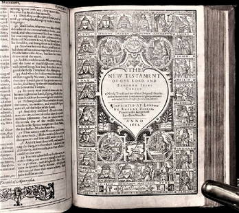
Sold20201612 King James Holy Bible, Genealogy / Map of CanonTHE HOLY BIBLE 1612 This is a very rare 1612 Quartos as there were very few produced to make ready for the 1613 Quartos.See Sold Price
Sold2016c. 1670 Engraved Holy Land + Mediterranean MapHistoric Maps c. 1670 Engraved Map of the Holy Land & Mediterranean Sea c. 1670, Historic Hand-Colored Engraved Map entitled: “Terra Sancta sive Promissionis olim Palestina recens delineata,” by FSee Sold Price
Sold2018Charles Wilhem - Binder of Maps of the Holy Land.Karte von Palastina von C.W.M. Van De Velde. Gotha, 1866. Eight color geographic maps depicting various areas of the Land of Israel by cartographer Charles Wilhem. Following a change in Ottoman EmpireSee Sold Price
Sold2021Manuscript Map of the Holy Land, early 18th Century[Manuscript map of the Holy Land] Pencil, ink, and watercolor on faux vellum with horizontal and vertical folding creases (8 segments) and no mounting guard; pencil grid visible in upper left and righSee Sold Price
Sold20221651 Speed Map of the Holy Land -- Canaan. Begun by Mr. John More Continued and Finished by JohnTitle: 1651 Speed Map of the Holy Land -- Canaan. Begun by Mr. John More Continued and Finished by John Speede Cartographer: J Speed Year / Place: 1651, London Map Dimension (in.): 15.1 X 20.6 in. ThiSee Sold Price
Sold2020Abraham Ortelius: Antique Map of the Holy Landwith 22 vignettes depicting the story of Abraham 16 1/4" x 20 1/4" sheetSee Sold Price
Sold2021Panoramic Map of the Holy LandMap of Eretz Israel, its cities and its holy sites including Jerusalem, Hebron, Jaffa, Tiberias and Safed. Originally made by Rabbi Chaim Solomon Pinie from Safed, and first printed in the 19th centurSee Sold Price
Sold2021Eleven Antique Maps of EuropeEleven Antique Maps of Europe , 16th-18th c., incl. Ptolemy from 1541 (4); a Blaeu map of "Regno di Napoli", Hondius map of the Holy Land, de Wit map of Southern Spain, an undated manuscript map of MeSee Sold Price
Sold20244 Antique Maps of Various LocationsFrench Map of Canada By Guillaume Del'Isle, Map Of Asia By Guiljelmo Blaeuw, Double Hemisphere map By Nicolao Visscher, Map Of The Holy Land Jerusalem, all maps are roughly 18" x 14"See Sold Price
Sold2022(HOLY LAND.) Abraham Ortelius. Terra Sancta.(HOLY LAND.) Abraham Ortelius. Terra Sancta. Double-page engraved map of the Holy Land. 16x21¼ inches sheet size, wide margins, Latin text on verso; original hand-color in full; minor toning andSee Sold Price
Sold2020ORTELIUS, ABRAHAM. Palestinae sive Totius TerraeORTELIUS, ABRAHAM. Palestinae sive Totius Terrae Promissionis Nova Descriptio. Double-page engraved map of the Holy Land. 17½x22¼ inches sheet size, wide margins, Latin text on verso; originSee Sold Price
Sold2023THREE ANTIQUE JEWISH NATIONAL FUND COLLECTION BOXES. Palestine and the United States, c. 1948. TwoTHREE ANTIQUE JEWISH NATIONAL FUND COLLECTION BOXES. Palestine and the United States, c. 1948. Two square boxes decorated with the map of the Holy land that are similar in style and one tubular shapedSee Sold Price
Jun 02Schilb Antiquarian Rare Books1871 Holy BIBLE & MAPS Holy Land Hitchcock Analysis Gruden Concordance Theology$82(2 bids)
May 18Trillium Antique Prints & Rare BooksDe Jode, Rare, pub. 1593 - Map of the Holy Land (Descriptio Et Situs Terrae Sanctae Alio Nomine$100(1 bid)
6 days LeftAlbion AuctionsMarmocchi, F. C. 1845 Hand Col Map. Holy Land. Persia Empire, Alexander the Great$5
May 18Trillium Antique Prints & Rare BooksPtolemy & Magini, pub. 1620 - 4 Maps of the Holy Land, Palestine, Persia, Turkey, Egypt$50
6 days LeftAlbion AuctionsSale & Psalmanazar 1779 Map. Paradise Mount Ararat & Babel. Holy Land$10(2 bids)
4 days LeftJasper521650 c. Stella Map of Germany's Harz Mountain Area -- Comitatus Mansfeldiae Descriptio$95
5 hrs LeftTrillium Antique Prints & Rare BooksDavid Roberts - View from under the Portico of the Temple of Dendera$200
5 hrs LeftTrillium Antique Prints & Rare BooksDavid Roberts - Fragments of the Great Colossi, at the Memnonium$200
May 18Trillium Antique Prints & Rare BooksDavid Roberts - The Hypaethral Temple at Philae, Called the Bed of Pharaoh$200
1 day LeftSchilb Antiquarian Rare Books1835 GOLD GILT King James Holy Bible Oxford Old/New + Book Common Prayer 2v SET$94(9 bids)


![Manuscript Map of the Holy Land, early 18th Century: [Manuscript map of the Holy Land] Pencil, ink, and watercolor on faux vellum with horizontal and vertical folding creases (8 segments) and no mounting guard; pencil grid visible in upper left and righ](https://p1.liveauctioneers.com/1968/225974/116712048_1_x.jpg?height=310&quality=70&version=1636655147)


