Sold20221893 Civil War Map of Washington and NE. Virginia -- Surveys for Military Defenses Map ofTitle: 1893 Civil War Map of Washington and NE. Virginia -- Surveys for Military Defenses Map of Northeastern Virginia and Vicinity of Washington [Sheet 1 Plate VII] Cartographer: US War Department YeSee Sold Price
Sold20221893 Civil War Map of Northern Virginia -- Sheet 2. Survey for Military Defenses Map of NortheasternTitle: 1893 Civil War Map of Northern Virginia -- Sheet 2. Survey for Military Defenses Map of Northeastern Virginia and Vicinity of Washington [Plate VII] Cartographer: US War Department Year / PlaceSee Sold Price
Sold20201892 Cowles Civil War Map of Battles in SoutheasternTitle: 1892 Cowles Civil War Map of Battles in Southeastern Virginia -- Military Department of Southeastern Virginia and Fort Monroe, 1861 [Plate XVI] Date: 1892, Washington Cartographer: C Cowles (coSee Sold Price
Sold20221893 Civil War Map of Virginia and Maryland Battles --Title: 1893 Civil War Map of Virginia and Maryland Battles -- …Battle of the Wilderness… [with] …Lynchburg… [with] …Hanging Rock… [with] Hagerstown, MD… etc [See Sold Price
Sold20201892 Cowles Civil War Map of Battles in SoutheasternTitle: 1892 Cowles Civil War Map of Battles in Southeastern Virginia -- Military Department of Southeastern Virginia and Fort Monroe Showing the Approaches to Richmond and Petersburg, 1861 [Plate XVIISee Sold Price
Sold20241893 Civil War Maps of Vicksburg and Jackson Areas and Battles -- …Defenses of Vicksburg,Title: 1893 Civil War Maps of Vicksburg and Jackson Areas and Battles -- …Defenses of Vicksburg, Miss… [with] …Map of Siege of Jackson, Miss… [with] …vicksburg and ViciniSee Sold Price
Sold20211864 U.S. Coast Survey Map of Washington D.C.,Approx. 23" X 40". Upper portion slight staining and minor loss as shown. Highly detailed Civil War era sea chart of part of the Potomac River, including Alexandria and Washington D.C. north to GeorgeSee Sold Price
Sold20221893 Civil War Map of Charleston, SC and Belmont MO Defenses and Battles -- …the Defenses ofTitle: 1893 Civil War Map of Charleston, SC and Belmont MO Defenses and Battles -- …the Defenses of Charleston City and Harbor... [with] …Plan of Belmont… [with] …Battle of BelSee Sold Price
Sold20201892 Cowles Civil War Map of Battles in SoutheasternTitle/Content of Map: 1892 Cowles Civil War Map of Battles in Southeastern Virginia Around Yorktown -- Military Reconnaissance Department of Virginia [and] Yorktown to Williamsburg [Plate XVIII] CartoSee Sold Price
Sold2022(CIVIL WAR.) Edmund and George William Blunt. E. & G.W. Blunt's Corrected Map of Washington and the(CIVIL WAR.) Edmund and George William Blunt. E. & G.W. Blunt's Corrected Map of Washington and the Seat of War on the Potomac. Hand-colored tinted lithographed map of Northern Virginia and central MaSee Sold Price
Sold201619thc Civil War Map, Invasion of PennsylvaniaOriginal 19th Century Map, Page from "Harper's Pictorial History Of The Civil War." Shows Pennsylvania, Maryland ,Virginia & Delaware. Gettysburg, Philadelphia & Washington. June, 1863. Approx 10" X 1See Sold Price
Sold2021(CIVIL WAR.) U.S. Coast Survey; Nicholson, Walter L.(CIVIL WAR.) U.S. Coast Survey; Nicholson, Walter L. (compiler.) Map of Eastern Virginia. Chromolithographed map of Virginia from the Chesapeake Bay to Lexington. 26x21 inches sheet size, wide marginsSee Sold Price
Sold20241864 Map of Virginiaprinted at the Coast Survey Office. A.D. Bache Supdt. Civil War era railroad map. Framed and under glass. Overall size is 27" x 41" Map has some creases from being folded and stains.See Sold Price
Sold2015Battle Maps from Atlas of the Union & ConfederateLithographed by Julius Bien & Co., N.Y., under the direction of Daniel S. Lamont, Government printing office, Washington, D.C., 1893, including Plates LXXXI, LXXXII, LXXXIII, LXXXIV & LXXXV. All are 1See Sold Price
Sold2015Battle Maps from Atlas of the Union & ConfederateLithographed by Julius Bien & Co., N.Y., under the direction of Daniel S. Lamont, Government printing office, Washington, D.C., 1893, including Plates, CXVI, CXVII, CXVIII, CXIX, CXX. All are 18.5 x 2See Sold Price
Sold2015Battle Maps from Atlas of the Union & ConfederateLithographed by Julius Bien & Co., N.Y., under the direction of Daniel S. Lamont, Government printing office, Washington, D.C., 1893, including Plates, CXXVI, CXXVII, CXXVIII, CXXIX, CXXX. All are 18.See Sold Price
Sold2015Battle Maps from Atlas of the Union & ConfederateLithographed by Julius Bien & Co., N.Y., under the direction of Daniel S. Lamont, Government printing office, Washington, D.C., 1893, including Plates, CXXI, CXXII, CXXIII, CXXIV, CXXV. All are 18.5 xSee Sold Price
Sold2022(CIVIL WAR.) P.S. Duval & Son. Military Map of the United States & Territories(CIVIL WAR.) P.S. Duval & Son. Military Map of the United States & Territories Showing the Location of the Military Posts, Arsenals, Navy Yards, & Ports of Entry. Hand-colored lithographed pocket mapSee Sold Price
Sold20191862 1ed War with South CIVIL WAR Military Tomes1862 1ed War with South CIVIL WAR Military Tomes Illustrated Gettysburg MAPS The American Civil War played an important role in the expansion and growth of book publication in the United States, as peSee Sold Price
Sold20221871 Confederate 1ed Robert E Lee Civil War Military Army Illustrated CSA Maps1871 Confederate 1ed Robert E Lee Civil War Military Army Illustrated CSA Maps “Human virtue should be equal to human calamity.” ¬¬--Robert E. Lee John Esten Cooke was an American noSee Sold Price
Sold20241892 Cowles Civil War Map of Battles in Gettysburg, Virginia, W Virginia and Maryland -- Sketch ofTitle: 1892 Cowles Civil War Map of Battles in Gettysburg, Virginia, W Virginia and Maryland -- Sketch of the battle of McDowell, VA. [and] Route Map of Gettysburg Campaign Lt-Gen T.J. Jackson [and] SSee Sold Price
Sold20221893 Government Map of Civil War Era United States -- Map of the United States of America ShowingTitle: 1893 Government Map of Civil War Era United States -- Map of the United States of America Showing the Boundaries of the Union and Confederate Geographical Divisions and Departments CartographerSee Sold Price
Sold20221893 Government Map of Civil War Era United States -- Map of the United States of America ShowingTitle: 1893 Government Map of Civil War Era United States -- Map of the United States of America Showing the Boundaries of the Union and Confederate Geographical Divisions and Departments; Plate CLXIVSee Sold Price
Sold20221893 Government Map of Civil War Era United States -- Map of the United States of America ShowingTitle: 1893 Government Map of Civil War Era United States -- Map of the United States of America Showing the Boundaries of the Union and Confederate Geographical Divisions and Departments; Plate CLXIISee Sold Price
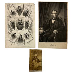
Jun 22Lakeshore Event CenterEphemera, Civil War Generals, Abraham Lincoln, Ulysses Grant, Lot of 3$30(1 bid)
Jun 23Schilb Antiquarian Rare Books1918 Robert E Lee Civil WAR Confederate General CSA Battles MAPS Illustrated$9(3 bids)
Jun 23Schilb Antiquarian Rare Books1890 1ed Confederate Memoirs of Joseph Johnston & Jefferson Davis Civil War CSA$44(2 bids)
1 day LeftJasper521893 Civil War Map Washington, Paducah, KY and Logan's Cross-Roads plus Mill Springs, KY -- Defenses$70
5 days LeftHolabird Western Americana CollectionsJefferson Davis Confederate Stamp Sheet, Scott 11 [179366]$750
5 days LeftEarly American History Auctions1863 JOHN ARCHIBALD CAMPBELL ALS Re: a Friends Prisoner Exchange Confederate Asst. Secretary of War$450
5 days LeftEarly American History AuctionsAbraham Lincoln Gettysburg Address on Muslin Cotton Fabric measuring 21.5 x 15.5$100
5 days LeftEarly American History Auctions1905 Civil War General OLIVER OTIS HOWARD Typed Letter Signed as President of the Lincoln Memorial$300
3 days LeftWeatherham Estate TreasuresAbraham Lincoln Bronze Bust Sculpture On Marble Base - Signed Original - 10lbs$400
1 day LeftJasper521853 Williamson Map of Tejon Pass, California -- Map and Profile of the Tejon Pass from explorations$55
1 day LeftJasper521853 Williamson Map of California's Tejon Pass Region -- Map and Profile of the Cañada de las$55
5 days LeftEarly American History AuctionsRinggold Light Artillery FIRST DEFENDERS, Rare Civil War Reunion Printed Silk Ribbon, Reading, PA.$150
5 days LeftEarly American History Auctions1862 Civil War Dated, Union General David Hunter Autograph Letter Signed Involving 3 Union Generals$600
5 days LeftEarly American History Auctions1864 Civil War General Order, President Lincoln Commutes the Death Sentences for Two Soldiers$120
5 days LeftEarly American History Auctions1865 Treasury Department Circular, Canal Boats Doing Business With Indian Tribes Are Exempt From Tax$220
1 day LeftJasper521893 Civil War Map of Knoxville Area -- Topographical Map of the Approaches and Defences of$70
1 day LeftJasper521893 Civil War Map of Siege of Yorktown, Battle of Siloh and Army of Ohio Operations -- Plan of$55
1 day LeftJasper521893 Civil War Map of Yorktown -- Secession Works at Yorktown [with] The Position of Yorktown with$55
5 days LeftSimpson Galleries, LLC.JULIUS BIEN (1826-1909) AN AMERICAN CIVIL WAR RECONNAISSANCE MAP, "Map of Texas and Part of New$100


![1893 Civil War Map of Washington and NE. Virginia -- Surveys for Military Defenses Map of: Title: 1893 Civil War Map of Washington and NE. Virginia -- Surveys for Military Defenses Map of Northeastern Virginia and Vicinity of Washington [Sheet 1 Plate VII] Cartographer: US War Department Ye](https://p1.liveauctioneers.com/5584/241996/125442504_1_x.jpg?height=310&quality=70&version=1648585952)


![1893 Civil War Map of Northern Virginia -- Sheet 2. Survey for Military Defenses Map of Northeastern: Title: 1893 Civil War Map of Northern Virginia -- Sheet 2. Survey for Military Defenses Map of Northeastern Virginia and Vicinity of Washington [Plate VII] Cartographer: US War Department Year / Place](https://p1.liveauctioneers.com/5584/270923/141842311_1_x.jpg?height=310&quality=70&version=1670433092)
![1892 Cowles Civil War Map of Battles in Southeastern: Title: 1892 Cowles Civil War Map of Battles in Southeastern Virginia -- Military Department of Southeastern Virginia and Fort Monroe, 1861 [Plate XVI] Date: 1892, Washington Cartographer: C Cowles (co](https://p1.liveauctioneers.com/5584/159675/80583510_1_x.jpg?height=310&quality=70&version=1579644740)
![1893 Civil War Map of Virginia and Maryland Battles --: Title: 1893 Civil War Map of Virginia and Maryland Battles -- …Battle of the Wilderness… [with] …Lynchburg… [with] …Hanging Rock… [with] Hagerstown, MD… etc [](https://p1.liveauctioneers.com/5584/236932/122768417_1_x.jpg?height=310&quality=70&version=1644981394)

![1893 Civil War Maps of Vicksburg and Jackson Areas and Battles -- …Defenses of Vicksburg,: Title: 1893 Civil War Maps of Vicksburg and Jackson Areas and Battles -- …Defenses of Vicksburg, Miss… [with] …Map of Siege of Jackson, Miss… [with] …vicksburg and Vicini](https://p1.liveauctioneers.com/5584/325789/175390306_1_x.jpg?height=310&quality=70&version=1713301948)

![1893 Civil War Map of Charleston, SC and Belmont MO Defenses and Battles -- …the Defenses of: Title: 1893 Civil War Map of Charleston, SC and Belmont MO Defenses and Battles -- …the Defenses of Charleston City and Harbor... [with] …Plan of Belmont… [with] …Battle of Bel](https://p1.liveauctioneers.com/5584/255516/132924128_1_x.jpg?height=310&quality=70&version=1658870031)
![1892 Cowles Civil War Map of Battles in Southeastern: Title/Content of Map: 1892 Cowles Civil War Map of Battles in Southeastern Virginia Around Yorktown -- Military Reconnaissance Department of Virginia [and] Yorktown to Williamsburg [Plate XVIII] Carto](https://p1.liveauctioneers.com/5584/182355/91727334_1_x.jpg?height=310&quality=70&version=1603285541)


![1892 Cowles Civil War Map of Battles in Gettysburg, Virginia, W Virginia and Maryland -- Sketch of: Title: 1892 Cowles Civil War Map of Battles in Gettysburg, Virginia, W Virginia and Maryland -- Sketch of the battle of McDowell, VA. [and] Route Map of Gettysburg Campaign Lt-Gen T.J. Jackson [and] S](https://p1.liveauctioneers.com/5584/329422/177662185_1_x.jpg?height=310&quality=70&version=1715717898)


![Jefferson Davis Confederate Stamp Sheet, Scott 11 [179366] (1 of 1)](https://p1.liveauctioneers.com/2699/331499/178846702_1_x.jpg?height=282&quality=70&version=1717095214)


![1893 Civil War Map of Yorktown -- Secession Works at Yorktown [with] The Position of Yorktown with (1 of 1)](https://p1.liveauctioneers.com/5584/331064/178466378_1_x.jpg?height=282&quality=70&version=1716924723)
