Sold20161940’s-1960’s Canadian & U.S. Road MapsLot of 19 assorted 1940’s-1960’s Canadian & U.S. recreational, sightseeing & state highway system maps includes: Alabama highway, Pennsylvania highway, Maine highway, New Jersey highway, New YorkSee Sold Price
Sold20161940’s & 1960’s Travel BrochuresLot of 23 assorted 1940’s & 1950’s escorted tour company travel destination brochures includes: Canadian & U.S. city & state destinations by cruise ship or by train. CONDITION: 11 have tour companSee Sold Price
Sold2021Shell Tin Litho Road Maps DisplayCanadian. 1940s. Lithographed tin. Includes an assortment of seventeen (17) used road maps. Marked, "St. Thomas Metal Signs Ltd. St. Thomas Ontario" upper rear. 19 1/2 x 13". One added mounting hole tSee Sold Price
Sold20231926-38 22 Vintage Northeast U.S. Road MapsIncludes 1936 Texaco NC & SC Road Map; 1938 Texaco PA Road Map; 1928 Standard Oil Road Map of Middle Atlantic States; 1937 Texaco NY & Long Island NJ Road Map; 1937 Texaco DE, MD, VA, WV, NC & SC RoadSee Sold Price
Sold2023Lot c1940s-50s US Road Maps, Attraction BrochuresFrom the papers of a missionary and teacher who lived in Japan 1913-1930, her itinerary, notes, and brochures for her trip home and the sights she sees upon her return to the US and later, including tSee Sold Price
Sold20212 Large Scrapbooks of Shell Oil 30's US Road Map BooksPair of Folio Style Shell Oil 1930s US Road Map Books. These map booklets, with tabs for various US States like North Carolina, South Carolina, Virginia, West Virginia, and Texas, were published by ShSee Sold Price
Sold2020Eastern US Road MapTitle/ Content of Map:Eastern US Road Map Date Printed: 1971 Cartographer: American Automobile Association Material/Medium: paper Dimensions: 30-fold. approx. 28x37.5 inches open, 4x6.5 inches folded.See Sold Price
Sold2020Eighteen (18) U.S. Washington Silver QuartersLot of Eighteen (18) 1940s - 1960s U.S. Washington Silver Quarters. Reverse: bust facing left. Obverse: eagle. Designed by John Flanagan. A few with mint marks "D" or "S". 24.3mm. Total weighs approx.See Sold Price
Sold2022Circa 1940"s California Road Maps & Bookletrated 8, 9"x4", all in good conditionSee Sold Price
Sold2022VINTAGE NORTH EASTERN US & FRENCH ROAD MAPSVINTAGE NORTH EASTERN US & FRENCH ROAD MAPS Road maps of the eastern seaboard of PA, NY, D.C., VA, MD, and NJ by AAA and Exxon. Also included are five Michelin maps of France.See Sold Price
Sold20211923 US Rail Road MapTitle: 1923 US Rail Road Map Author: McNally Materials: Ink on Paper Dimensions: 28"X21" Description: United States Rail Road Map dated 1923. Published by McNally & Co in Chicago. Shows detailed railSee Sold Price
Sold20211872 US Rail Road MapAuthor: Colton Title: 1872 US Rail Road Map Medium: Ink on Paper Dimensions: 19"X12" US Rail Road map dated 1872. Printed by Colton. Published by Sheldon & Co. in Washington D.C. Double folio map. ItSee Sold Price
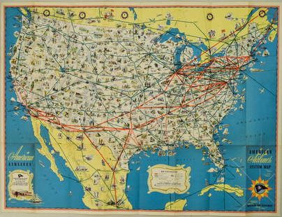
Sold20221940s American Airlines US Route Map -- American Airlines System MapTitle: 1940s American Airlines US Route Map -- American Airlines System Map Cartographer: American Airlines (General Drafting Co.) Year / Place: 1940s c. Map Dimension (in.): 24 X 32 in. Ths is an attSee Sold Price
Sold2020Roadmaps and EphemeraLot includes an Esso and a Gulf map, a large selection of American and international road maps from 1960s and 1970s, Sing a Song player book with xylophone, 25c Steel Pier program, a York PA bank bag,See Sold Price
Sold2020Road Map of New MexicoTitle/Content of Map: Road Map of New Mexico Date: 1936 Cartographer: GOUSHA, H. M. CO. Publisher: STANDARD OIL COMPANY OF TEXAS Size: 23Height - 17Width Full color road map. Entire US on reverse. CovSee Sold Price
Sold2019Nineteen 1940's War and Navy Department Road MapsNineteen Assorted 1940's War and Navy Department European Road Maps, used condition, wear, worn.See Sold Price
Sold2020Ephemera Lot including Road Maps, 13 star US Flag,Ephemera Lot including Road Maps, 13 star US Flag, Chicago Bears, etc.See Sold Price
Sold2019Antique Map US Rail Roads and Wagon Roads"Map of the Untied States showing the Limits Within Which Land Grants were Made by the Federal Government to Aid in the Construction of Railroads and Wagon Roads". Engraved and printed for the 9th CenSee Sold Price
Sold20211887 US Southern States RR MapTitle: 1887 US Southern States RR Map Author: Watson Materials: Ink on Paper Dimensions: 21"X14" Description: Rail road map of the US Southern States-Alabama, Geogia, South Carolina and Northern FloriSee Sold Price
1 hr LeftPropstoreTHE GOOD, THE BAD AND THE UGLY (1966) / HANG 'EM HIGH (1968) - David Frangioni Collection: US Double£150(1 bid)
1 hr LeftPropstoreTHE GOOD, THE BAD AND THE UGLY (1966) - David Frangioni Collection: US Paper Banner, 1968 (First Rel£275
1 hr LeftPropstoreA FISTFUL OF DOLLARS (1964) - David Frangioni Collection: US Paper Banner, 1967 (First Release)£400
6 days LeftJasper521852 Owen Geological Maps of the Pigeon River Minnesota -- (1) Geological Map Coast View and Section$45
6 days LeftJasper521893 Civil War Map of Siege of Yorktown, Battle of Siloh and Army of Ohio Operations -- Plan of$55
6 days LeftJasper521893 Civil War Map of Knoxville Area -- Topographical Map of the Approaches and Defences of$70