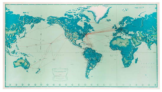
Sold20181947 World Route Map of US Flag Airlines --Title/Content of Map: 1947 World Route Map of US Flag Airlines -- International Air Routes of U.S. Flag Carriers as of April, 1947 Date: 1947 Cartographer: Anonymous Size: 10.9 x 21 in. This fascinatiSee Sold Price
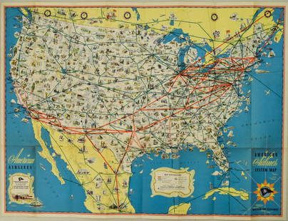
Sold20221940s American Airlines US Route Map -- American Airlines System MapTitle: 1940s American Airlines US Route Map -- American Airlines System Map Cartographer: American Airlines (General Drafting Co.) Year / Place: 1940s c. Map Dimension (in.): 24 X 32 in. Ths is an attSee Sold Price
Sold2018American Airlines Route Map World's Fair Line 1939American Airlines Route Map World's Fair Line 1939See Sold Price
Sold2022Vintage Air France Airline Travel Routes World MapVintage Air France Airline Travel Routes World Map, by Lucien Boucher (French, 1889-1971) color offset, C.1948. Framed. Size: 19.5'' x 33.75'', 50 x 86 cm (sight); 24.5'' x 39'', 62 x 99 cm (frame).See Sold Price
Sold2018Air France. Large World Map Airways Route Poster.Masse, Jean. Air France. Large World Map Airways Route Poster. Paris: R. Graindorge/Perceval, ca. 1961. Color map of the world detailing the airline's routes. Linen backed. 45 ½ x 81". Small browSee Sold Price
Sold2022Sabena Belgian World Airlines. Brussels: Marci, ca. 1966. R...Sabena Belgian World Airlines. Brussels: Marci, ca. 1966. Route map poster of Europe, Africa, and the Middle East labeled with Sabena’s routes as well as seasonal routes and connecting carriers.See Sold Price
Sold2021MAP, Eastern US, Phelps & EnsignEastern United States. Phelps & Ensign, Phelps & Ensign's Travellers' Guide, and Map of the United States, Containing the Roads, Distances, Steam Boat and Canal Routes &c., 1842 (dated). Hand Color. TSee Sold Price
Sold2019Pan American Airways System. World Map 1956.Pan American Airways System. World Map 1956. Art by John Brown, cartography by John Philip. Offset poster showing the airline’s routes across the world. 34 x 60”. Inpainting to lower image, minorSee Sold Price
Sold2018Pan American Airways System. World Map 1968Pan American Airways System. World Map 1968. Art by John Brown, cartography by John Philip. Offset poster showing the airline's routes across the world. Linen backed. 18 x 32". A.See Sold Price
Sold2021Palestine Map Printed for USA Soldiers - WW2Folding Map of Palestine, prepared and printed for the US Armed Forces during World War Two. One side shows a map of Palestine and the middle east, with a route from Bagdad and the Persian Gulf CommanSee Sold Price
Sold2023Limoges World Map, US Navy Plane, & Bon Voyage Cruise Ship Set of Miniature Porcelain CollectablesA delightful set of miniature porcelain collectable boxes by Limoges - featuring a world map, a US Navy plane, and a bon voyage cruise ship with a bottle of champagne inside. Each one is artfully handSee Sold Price
Sold20231950s Pan Am World Route Maps -- Route Maps Pan AmericanTitle: 1950s Pan Am World Route Maps -- Route Maps Pan American Cartographer: PanAm Year / Place: late 1950s c. Map Dimension (in.): 9 x 12 in. single page This is an outstanding 6 double page fold-ouSee Sold Price
Sold20191957 Quantas Airline Route Map -- Quantas AirlinesReserve Reduced! Title/Content of Map: 1957 Quantas Airline Route Map -- Quantas Airlines Route Map Date: 1957 Cartographer: Quantas Airlines Size: 11.2 x 8.3 in. This is a rather interesting advertisSee Sold Price
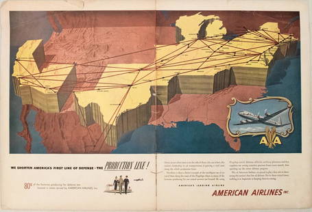
Sold20231950s American Airlines Route Map -- American Airlines Route MapTitle: 1950s American Airlines Route Map -- American Airlines Route Map Cartographer: American Airlines Year / Place: 1950s Map Dimension (in.): 12.5 X 19.2 in. joined This nice, large pictorial routeSee Sold Price
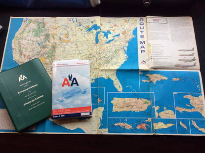
Sold2023Vintage American Airlines Route Map, American Airline Trip Book and BinderVintage American Airlines Route Map, American Airline Trip Book and BinderSee Sold Price
Sold20201930 Japanese Mainichi Newspaper World Air RouteTitle: 1930 Japanese Mainichi Newspaper World Air Route Pictorial Map -- Conquer Sky Sugoroku [World Air Route Map] Cartographer: Mainichi Newspaper Year / Place: 1930, Osaka Map Dimension (in.): 26.8See Sold Price
Sold20181957 Hawaiian Airlines Convair 340 Route Map --Title/Content of Map: 1957 Hawaiian Airlines Convair 340 Route Map -- Hawaiian Airlines Route Map Date: 1957 Cartographer: Hawaiian Airlines Size: 8.5 x 11.2 in. This is an attractive advertising showSee Sold Price
Sold2022Collection of Very Early 20th Century Tobacco Silks Including 6 Prized Collegiate Silks, Doll HouseCollection of Very Early 20th Century Tobacco Silks Including 6 Prized Collegiate Silks, Doll House Rugs, and Larger World and US Flags 40+. In between 1905 and 1910 that tobacco companies here in AmeSee Sold Price
Sold2022AJ Nystrom 2-Sided Chalkboard School Map, US & WorldLarge AJ Nystrom Roll Up 2 Sided Chalkboard Classroom Map Chart, US & World. Wonderful chart has maps of the United States and the World outlined in yellow on a black chalkboard backing. From the RoyaSee Sold Price
Sold20201946 Greyhound US Route Map -- Map of Greyhound LinesTitle/Content of Map: 1946 Greyhound US Route Map -- Map of Greyhound Lines and Principal Connecting Lines Cartographer: Greyhound Year/Place: 1946 c. Size: 15 X 21.5 in. unfolded This is a nice foldiSee Sold Price
Sold20235 Uncut World War II Map US Postal StampsThis lot contains 5 uncut sheets of 20 29-cent stamps that are part of the "50th Anniversary WWII" stamps that were released from 1991 to 1995. Each stamp has a different image of key events that happSee Sold Price
Sold2023Educator Shoes 9.75" World Map Wheel (1931) US AdvertisingEducator Shoes 9.75" World Map Wheel (1931) US Advertising Lists the Current Population, etc. Condition: EXC Reserve: $55.00 Shipping: Domestic: Flat-rate of $42.00 to anywhere within the contiguous USee Sold Price
Sold20221946 Greyhound US Route Map -- Map of Greyhound Lines and Princial Connecting LinesTitle: 1946 Greyhound US Route Map -- Map of Greyhound Lines and Princial Connecting Lines Cartographer: Greyhound Year / Place: 1946 c. Map Dimension (in.): 15 X 21.5 in. unfolded This is a nice foldSee Sold Price
Sold20191946 Greyhound US Route Map -- Map of Greyhound LinesTitle/Content of Map: 1946 Greyhound US Route Map -- Map of Greyhound Lines and Princial Connecting Lines Date: 1946Cartographer: Greyhound Size: 15 X 21.5 in. unfolded This is a nice folding map showSee Sold Price
Jun 20The Ross Art GroupOriginal Vintage Air France World Route Map Vickers Viscount Poster 1956 Constellation$600
Jun 20The Ross Art GroupOriginal Vintage United Air Lines Hawaii Woman with Lei Poster by Stan Galli$600
2 days LeftRapid Estate Liquidators and Auction GalleryThree Large Boy Scout jamboree Badges And ID Card$45
Jun 20The Ross Art GroupOriginal Vintage Fly TWA Jets India Pink Elephant Poster by David Klein c1960$600(1 bid)
3 days LeftFreeman's | Hindman[AFRICAN AMERICANA - WORLD WAR I]. Colored Man is No Slacker. Chicago, IL: E.G. Renesch, 1918.$250
Jun 07AUTOMOBILIA LADENBURG AUCTION1947, race programme "Grand Prix Automobile d´Europa Spa Francorchamps", June 29, 1947, first€150
JG AutographsNorman Fortier - WWII U.S. Army Air Forces Ace - Autographed Canadian Dec. of War 50 Anniv. Cover$10
Jun 20The Ross Art GroupOriginal Vintage United Air Lines Southern California Poster by Stan Galli$500
2 days LeftThe Bidder AuctionsThe map of the railways in the Land of Israel - published by the Surveying Department of the British$30
Jun 20The Ross Art GroupOriginal Vintage American Airlines Boston 1953 Poster by E.McKnight Kauffer$450
Jun 20The Ross Art GroupOriginal Vintage United Air Lines Poster by Stan Galli c1960 - Three Riders on Horses$600


![1930 Japanese Mainichi Newspaper World Air Route: Title: 1930 Japanese Mainichi Newspaper World Air Route Pictorial Map -- Conquer Sky Sugoroku [World Air Route Map] Cartographer: Mainichi Newspaper Year / Place: 1930, Osaka Map Dimension (in.): 26.8](https://p1.liveauctioneers.com/5584/187575/94368587_1_x.jpg?height=310&quality=70&version=1607465981)


![[AFRICAN AMERICANA - WORLD WAR I]. Colored Man is No Slacker. Chicago, IL: E.G. Renesch, 1918. (1 of 1)](https://p1.liveauctioneers.com/197/329785/177758399_1_x.jpg?height=282&quality=70&version=1715625218)


