Sold20201950s PanAm Route Map of Caribbean -- Pan AmericanTitle/Content of Map: 1950s PanAm Route Map of Caribbean -- Pan American Flight Map of New York and Caribbean Cartographer: PanAm Year/Place: late 1950s c. Size: 24 X 14 in. folded out A very nice rouSee Sold Price
Sold20221950s PanAm Route Map of Caribbean -- Pan American Flight Map of New York and CaribbeanTitle: 1950s PanAm Route Map of Caribbean -- Pan American Flight Map of New York and Caribbean Cartographer: PanAm Year/Place: late 1950s c. Dimensions: 24 X 14 in. folded out Description: A very niceSee Sold Price
Sold20191950s PanAm Route Map of Caribbean -- PanAmericanTitle/Content of Map: 1950s PanAm Route Map of Caribbean -- PanAmerican Flight Map of New York and Caribbean Date: late 1950s c. Cartographer: PanAm Size: 14x 24 in. folded out A very nice route map oSee Sold Price
Sold20191950s PanAm Route Map of Caribbean -- PanAmericanTitle/Content of Map: 1950s PanAm Route Map of Caribbean -- PanAmerican Flight Map of New York and Caribbean Date: late 1950s c. Cartographer: PanAm Size: 14x 24 in. folded out A very nice route map oSee Sold Price
Sold2018PanAm: Vintage Route Map of Caribbean, 1950sTitle/Content of Map: 1950s PanAm Route Map of Caribbean -- PanAmerican Flight Map of New York and Caribbeanan Date Printed: 1950s c. Cartographer: PanAm Size: 14 x 24 in. folded out A very nice routeSee Sold Price
Sold20231950s PanAm Route Map of Caribbean with Personal Notations -- PanAmerican Flight Map of New York andTitle: 1950s PanAm Route Map of Caribbean with Personal Notations -- PanAmerican Flight Map of New York and Caribbean Cartographer: PanAm Year / Place: late 1950s c. Map Dimension (in.): 14x 24 in. foSee Sold Price
Sold20221950s PanAm Route Map of Caribbeanan -- PanAmerican Flight Map of New York and CaribbeananTitle: 1950s PanAm Route Map of Caribbeanan -- PanAmerican Flight Map of New York and Caribbeanan Cartographer: PanAm Year / Place: late 1950s c. Map Dimension (in.): 14x 24 in. folded out A very niceSee Sold Price
Sold20211950s PanAm Route Map of Caribbeanan -- PanAmericanTitle: 1950s PanAm Route Map of Caribbeanan -- PanAmerican Flight Map of New York and Caribbeanan Cartographer: PanAm Year / Place: late 1950s c. Map Dimension (in.): 14x 24 in. folded out A very niceSee Sold Price
Sold20181950s PanAm Route Map of Caribbeanan -- PanAmericanTitle/Content of Map: 1950s PanAm Route Map of Caribbeanan -- PanAmerican Flight Map of New York and Caribbeanan Date: late 1950s c. Cartographer: PanAm Size: 14x 24 in. folded out A very nice route mSee Sold Price
Sold20181950s PanAm Route Map of Caribbeanan -- PanAmericanTitle/Content of Map: 1950s PanAm Route Map of Caribbeanan -- PanAmerican Flight Map of New York and Caribbeanan Date: late 1950s c. Cartographer: PanAm Size: 14x 24 in. folded out A very nice route mSee Sold Price
Sold20231950s PanAm Route Map of Caribbeanan -- PanAmerican Flight Map of New York and CaribbeananTitle: 1950s PanAm Route Map of Caribbeanan -- PanAmerican Flight Map of New York and Caribbeanan Cartographer: PanAm Year / Place: late 1950s c. Map Dimension (in.): 14x 24 in. folded out A very niceSee Sold Price
Sold20231950s PanAm Route Map of South America's East Coast -- Pan American Flight Map, South America EastTitle: 1950s PanAm Route Map of South America's East Coast -- Pan American Flight Map, South America East Coast Cartographer: PanAm Year / Place: late 1950s c. Map Dimension (in.): 23.5 X 16.8 in. folSee Sold Price
Sold20171950 Map of PanAm Airline Caribbean Routes1950 Map of PanAm Airline Caribbean Routes -- Pan American Flight Map New York and Caribbean. PanAm, 1950 ca., A nice folding map of Pan American Airline routes to Caribbean from New York City & MiamiSee Sold Price
Sold20231950s Pan Am World Route Maps -- Route Maps Pan AmericanTitle: 1950s Pan Am World Route Maps -- Route Maps Pan American Cartographer: PanAm Year / Place: late 1950s c. Map Dimension (in.): 9 x 12 in. single page This is an outstanding 6 double page fold-ouSee Sold Price
Sold20181957 Route Map of Pan American Airline to Mexico,Title/Content of Map: 1957 Route Map of Pan American Airline to Mexico, Central America and Part of Caribbean -- Pan American Flight Map [to] Mexico & Central America Date: 1957 Cartographer: PanAm SiSee Sold Price
Sold2018Pan American Airways Circa 1950's System Route MapPan American Airways Circa 1950's System Route MapSee Sold Price
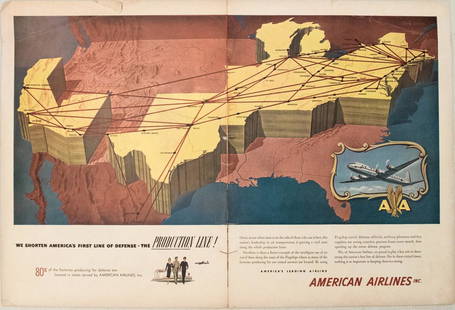
Sold20231950s American Airlines Route Map -- American Airlines Route MapTitle: 1950s American Airlines Route Map -- American Airlines Route Map Cartographer: American Airlines Year / Place: 1950s Map Dimension (in.): 12.5 X 19.2 in. joined This nice, large pictorial routeSee Sold Price
Sold2023PAN AMERICAN AIRLINES ROUTE MAP. "Fastest way between… USA & Latin America" 1935Title: PAN AMERICAN AIRLINES ROUTE MAP. "Fastest way between… USA & Latin America" 1935 Description: Consult this map for fastest way between all points in the United States and Latin America' bSee Sold Price
Sold2018Pan American Jet Clipper Route Maps 1964Pan American jet clipper route maps, dated 8/64.See Sold Price
Sold20201956 Pan Am World and Germany Route Map -- WillkommenTitle: 1956 Pan Am World and Germany Route Map -- Willkommen an Bord! Pan Am Cartographer: Pan American Airways Year / Place: 1956 Map Dimension (in.): 15.3 X 8.3 in. A very nice pictorial map of theSee Sold Price
Sold2019Pan Am Pan American Flight Map New York CaribbeanTitle/Content of Map: Pan Am Pan American Flight Map New York Caribbean Date: c1960 Cartographer: ANONYMOUS Publisher: PAN AM AIRLINES Size: 24.25Height - 14.5Width Seat-back pocket map for flights toSee Sold Price
Sold2018Pan American World Airways Flight Map The CaribbeanPan American World Airways flight map "The Caribbean".See Sold Price
Sold20201950s Pan Am Flight Map of Mexico and Central AmericaTitle: 1950s Pan Am Flight Map of Mexico and Central America -- Pan American Flight Map of Mexico and Central America Date: 1950s Cartographer: Pan American Size: 17.5 x 24 in. folded out Additional ISee Sold Price
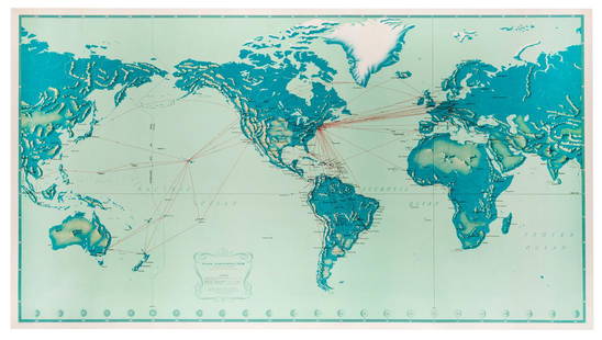
Sold2019Pan American Airways System. World Map 1956.Pan American Airways System. World Map 1956. Art by John Brown, cartography by John Philip. Offset poster showing the airline’s routes across the world. 34 x 60”. Inpainting to lower image, minorSee Sold Price
1 day LeftJasper52SOUTH AMERICA. La Plata & Chilé. Chile Argentina Uruguay Bolivia. SDUK 1851 map$40
1 day LeftJasper52SOUTH AMERICA.La Plata and Chilé.Chile Argentina Uruguay Bolivia.SDUK 1844 map$40
Jun 08Simpson Galleries, LLC.J.H. Young (1792-1870) AN AMERICAN FEDERAL PERIOD MAP, "Mitchell's Travellers Guide Through the$500
Jun 08Simpson Galleries, LLC.JULIUS BIEN (1826-1909) AN AMERICAN CIVIL WAR RECONNAISSANCE MAP, "Map of Texas and Part of New$100
Jun 08Early American History Auctions1853 Map, Basin of the St. Lawrence, by T. Keefer showing Natural + Artificial North American Routes$220
1 day LeftWhite Knight Auction, IncDiego Rivera, 'Pan-American Unity' 1986, Limited Edition Lithograph$200
28 mins LeftMynt Auctions1901 Pan-American Exposition Silver Medal HK-287 So-Called Dollar NGC AU - RARE!$480
Jun 29JM Hobby Supply and Railroad Artifact AuctionsFlorence & Cripple Creek RR Public Timetable-September 1894$400


![1957 Route Map of Pan American Airline to Mexico,: Title/Content of Map: 1957 Route Map of Pan American Airline to Mexico, Central America and Part of Caribbean -- Pan American Flight Map [to] Mexico & Central America Date: 1957 Cartographer: PanAm Si](https://p1.liveauctioneers.com/5584/124256/63192867_1_x.jpg?height=310&quality=70&version=1530636078)