Sold20182 MAPS FRAMED, SCOTLAND OF OLD, IRELAND, BULLOCK MAPSTwo framed maps, Scotland of Old and Ireland. Windowbox style frames. 1969 Bullock Pictorial Historical Map of Ireland - This is a delightful 1969 L.G. Bullock pictorial historical map of Ireland. BulSee Sold Price
Sold20212 Framed Alain Manesson Maps - Scotland & Ceylon, 1683**Originally Listed At $200** Cartographer Alain Manesson Mallet (French, 1630-1706)."Royaume D'Ecosse" (Scotland) AND "Isle de Ceylan" (Sri Lanka, formerly Ceylon). Published in Allain M. Mallet's "DSee Sold Price
Sold2023Antique Carte Pour L' Intelligence Du Livre Institute L' Esprit De S Loix Old World Framed MapAntique French framed old world map with gold tone frame. Professionally framed. Measures 15 1/2" x 24" total with 9" x 18" matte.See Sold Price
Sold2018Set of 2 Framed Prints of Antique MapsSet of 2 Framed Antique Maps - Small map of England and Scotland. Large Map of the Mediterranean with ships. Measures approx. Large map 28" tall x 31" w x 1" deep. Small map 12" tall x 15" w x 3/4" deSee Sold Price
Sold20182 Framed antique maps2 Framed antique maps, probably from an old atlas, British America & The United States, map drawn & engraved by J. Rapkin, illustrations by H. Warren & illustrations by R. Wallis, Maps are 10" x 13",See Sold Price
Sold2022Collection of 5 Framed Maps of Northern Ireland, 9" x 13 1/2".Collection of 5 Framed Maps of Northern Ireland, 9" x 13 1/2".See Sold Price
Sold2023[ANTIQUE MAP] ANTIQUE MAP OF SOUTHERN SCOTLAND. c. 1650s[ANTIQUE MAP] CARTE L'ECOSSE SUIVANT LES DERNIERES RELATIONS par N...Sanson, Circa 1650s Framed size (approx): 8.1/4"x10.1/4" Image size: (approx):6.3/4"x7.1/2" Framed. This map hasn't been examined uSee Sold Price
Sold2022John SPEED: Two Antique Maps of IrelandTwo framed antique maps of Ireland by John Speed, a well known English cartographers circa 17th century. [Maps: 15" H x 20" W; Frames: 24" H x 28 1/2" W].See Sold Price
Sold20202 Willem Blaeu Maps; Cadiz & Hibernia Ireland 16402 Willem Blaeu Maps: Cadiz and Hibernia Ireland 1640 Amsterdam. Framed in Burl veneer with small mirror mats. Appear in good condition not examined out of frames. Visible height of maps 15 inches (38See Sold Price
Sold2020Early Framed MapEarly framed map "MAP OF THE / OLD RELIABLE / HANNIBAL / AND ST. JOSEPH / SHORT LINE". Sight 23" x 21 1/2".See Sold Price
Sold2016(2) ANTIQUE IRELAND MAPSCarte D' Irlande map published in 1867 by Alvin J. Johnson New York. Measures 10 3/4" x 15 3/4" (Framed 19 1/2" x 23 1/2") and a Jacques Nicolas Bellin A Chart of Ireland 1803 hand colored map. MeasurSee Sold Price
Sold2022FRAMED MAP *PICTURAL PLAN OF IRELAND*FRAMED MAP *PICTORIAL PLAN OF IRELAND* APPROXIMATELY 17 1/2 IN X 21 1/2See Sold Price
Sold2024Willen Janszoon Blaeu, Scotia Regnum(Dutch, 1571-1638) Hand colored engraved map of Scotland, c. 1642. Framed double sided with book text on verso. Sight: 16-1/2"h x 21-1/4"w Overall: 26"h x 30-3/4"w Provenance: Paulus Swaen, Inc. IndiaSee Sold Price
Sold2022A SET OF FOUR FRAMED MAPS Prince of Wales Maps, engraved and published by G.F. Crutchley America...A SET OF FOUR FRAMED MAPS Prince of Wales Maps, engraved and published by G.F. Crutchley Americas, Palestine, Ireland and Scotland, together with a Stannard & Sons Perspective view of Asiatic, Turkey,See Sold Price
Sold20211836 Map of Dublin, IrelandDESCRIPTION: Drawn by W. B. Clarke, engraved by E. Turrell, and published by Baldwin & Cradock. Conservation framed. MEASUREMENTS: Map 11" high x 15" wide; overall with frame 20-1/2" high x 23-1/2" wiSee Sold Price
Sold2017Framed Print Basset Mirror Co. Old World MapFramed Print. Basset Mirror Co. print depicting an old world map, 28 3/4"h. 34 1/2"w.See Sold Price
Sold2021Group of 2 Rudolf Lesch Fine Arts Framed MapsIncludes a map of South America and North America, 13 x 16 inches eachSee Sold Price
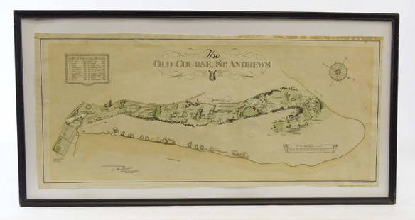
Sold2019Scotland Early Golf MapOld Course St. Andrews Map. Surveyed by A. MacKenize Architect, 1924. McCorquodale & Co., Glasgow, C. 1924. Sight 10 3/4" x 24 1/2".See Sold Price
Sold2022Disneyland Park Map Framed Pin SetWith sealed COA, original box. 16 1/2 x 18 inchesSee Sold Price
Sold2017Thomas Kitchin, Maryland and Scotland maps(Scottish, 1718-1784)., "Map of Maryland with the Delaware counties and the southern part of New Jersey," hand colored map, circa 1750, 7 x 9 in. , framed and "Scotland," circa 1760, 7 1/2 x 9 in. , fSee Sold Price
Sold2019MAPS - Ireland. Manesson MalletIreland. Allain Manesson Mallet, [Lot of 2] Royaume d'Irlande [and] Isle d Irlande, 1683 (published). A nice pair of copper-engraved maps showing counties, lakes, and rivers. Titles in simple block foSee Sold Price
Sold2023Framed Map of MontanaMap of Montana from 1906, 17" x 25" sight, 24" x 32 1/2" framed.See Sold Price
Sold2019Two Maps by Johnson & Ward, consisting of "Ireland andTwo Maps by Johnson & Ward, consisting of "Ireland and Scotland," 1863-1866, hand colored, H.- 8 in., W.- 26 1/2 in.; together with "England and Wales," 1862, hand colored, H.- 26 1/2 in., W.- 18 in.See Sold Price
Sold2020Antique Picot & Co map of England and WalesAntique Picot & Co framed map of England and Wales with part of Scotland. Overall size 37"h x 31"w overall. Paper sight size 27 1/2"h x 21 1/4"w. Published by Picot & Co London and Manchester.See Sold Price
Jun 18DOYLE Auctioneers & AppraisersA block puzzle with maps of Europe, England, Ireland, Scotland, America and the World$100
Jun 01Trillium Antique Prints & Rare BooksSanson - Map of the British Isles (Ireland, Scotland, England)$75
5 days LeftNY Elizabeth 1792 OLD INDIA HISTORY ANTIQUE ILLUSTRATED WITH MAPS OF THE EIGHTEENTH CENTURY IN FRENCH$50
3 days LeftJasper521733 BIBLE OLD TESTAMENT COMMENTARY by CALMET VELLUM FOLIO antique w/ LARGE MAP$160
4 days LeftJasper52Cathedral in Jona, Scotland. Antique engraving old print from 18th century (1772)$60


![[ANTIQUE MAP] ANTIQUE MAP OF SOUTHERN SCOTLAND. c. 1650s: [ANTIQUE MAP] CARTE L'ECOSSE SUIVANT LES DERNIERES RELATIONS par N...Sanson, Circa 1650s Framed size (approx): 8.1/4"x10.1/4" Image size: (approx):6.3/4"x7.1/2" Framed. This map hasn't been examined u](https://p1.liveauctioneers.com/8321/286473/155324781_10_x.jpg?height=310&quality=70&version=1687035305)
![John SPEED: Two Antique Maps of Ireland: Two framed antique maps of Ireland by John Speed, a well known English cartographers circa 17th century. [Maps: 15" H x 20" W; Frames: 24" H x 28 1/2" W].](https://p1.liveauctioneers.com/1221/264089/138965458_1_x.jpg?height=310&quality=70&version=1667576821)


![MAPS - Ireland. Manesson Mallet: Ireland. Allain Manesson Mallet, [Lot of 2] Royaume d'Irlande [and] Isle d Irlande, 1683 (published). A nice pair of copper-engraved maps showing counties, lakes, and rivers. Titles in simple block fo](https://p1.liveauctioneers.com/6576/136723/69438030_1_x.jpg?height=310&quality=70&version=1550846033)


