Sold20174 19th c. KY & TN Maps1st item: "Kentucky and Tennessee" Map, by Sidney E. Morse and Samuel Breese, published by Harper and Brothers, 1845. Colored cerograph of Kentucky and Tennessee depicting towns, roads, county lines,See Sold Price
Sold2021KY TN OH IN IL, State Populations 1831 Goodrich MapEarly 19th c. Hand-colored Map, Kentucky Tennessee Ohio Indiana Illinois, State Populations | Published: Boston: S.G. Goodrich, 1831 | Very nice hand colored engraved map showing each state with populSee Sold Price
Sold2021Lot of 4 Russian Books, 19th C. Bible, MapsLot of four likely Russian books with what look like Cyrillic lettering. Includes a Bible and a book of that appears to be about seafaring with a large fold-out river map.Dimensions range from 9.75 inSee Sold Price
Sold2021Colton's Kentucky and TennesseePublication Date: 1869 Title: Colton's Kentucky and Tennessee Cartographer: Publisher: G.W. and C.B. Colton No.58, 59. Double folio Colton KY/TN maps are quite scarce. Dimensions: 16"H. x 26.5"W. ReseSee Sold Price
Sold202219th C Maps Isles of Shoals, Portsmouth NHPortsmouth NH maps, Dated 1816 Plan of Portsmouth Harbour published by Edmund M. Blunt NY 4.5" x 7.5". Dated 1841 hand colored map of the Isles of Shoals published by E & GW Blunt NY. 8.5" x 10.25".See Sold Price
Sold2017Original 19th C. Map of BostonOriginal 19th C. Map of Boston, framed. Image size: 7 x 4 inches.See Sold Price
Sold202019th c. Map19th c. map of New York, H.S. Tanner, hand-colored lithograph. Sight 12 1/2" x 15 1/4".See Sold Price
Sold2023Late 19thc Map, Thalheimer's The World, Colonial PossessionsLate 19th Century, 1897, map of The World, Map XV, Showing Colonial Possessions by A von Steinwehr, from Thalheimer's Medieval and Modern History. 7 1/4" X 10 1/4".See Sold Price
Sold20173 - Japanese Ceramics; Map Vase, Sake Vase3 - Japanese Ceramics; 19th C Map of Japan Vase decorated with blue and white overglaze enamels; together with two Sake Bottles each with calligraphy. Good condition. Height of Map vase 11 1/4 inchesSee Sold Price
Sold202118th-19th C. Botanical and Nautical printsincludes 4 Botanical plates 1790's by W. Curtis a 19th C. Map of France, Mitchell, 1847. Battle of Trafalgar, October 21st 1805, from 'The Naval Achievements of Great Britain' by James Jenkins, engravSee Sold Price
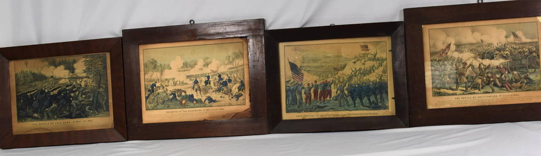
Sold202119THC CIVIL WAR HAND COLORED LITHOGRAPHSLot of 4 19thc Civil War hand colored lithographs by Currier and Ives in original frames,3 with glass.. Entitled The Battle of Chattanooga,Tn November 24th 1863,The Battle of Gettysburg PaJuly 3rd 186See Sold Price
Sold2023Six Antique Maps of America Engravings, 19th c., H.- 7 1/4 in., W.- 4 1/2 in., Framed- H.- 15 in.,Six Antique Maps of America Engravings, 19th c., includes: "Map 8 1776 / Framing Declaration," "Map 5 1692 / New France: Map of the Discoveries of Marquette, La Salle and Other Frenchmen," "Map No. 12See Sold Price
Sold2020Three 19th C English MapsThree 19th c English Maps: Scarborough 6.5 x 4"; Estuary of the Thames 10 x 7.5"; and folding map of Lincolnshire 11 15". Very Good. Reserve: $30.00 Shipping: Domestic: Flat-rate of $5.00 to anywhereSee Sold Price
Sold202119TH C. POCKET MAP OF THE WHITE MOUNTAINSBufford's litho Boston pocket map White Mountains and vicinity, hand inscribed indistinct name, and "June 1860", in the upper border, 14 3/4 x 12 3/4 inchesSee Sold Price
Sold2015Victorian Walnut Folio StandBritish or American, late 19th century, the map or print supports with ring-and-baluster turned ratcheted adjustable supports on a trestle-form base, 47-1/4 x 30-1/2 x 21-1/2 in. scattered light surfaSee Sold Price
Sold2023Set (4) Louis Philippe dining chairs, stamped 'TN'Set (4) Louis Philippe dining chairs, stamped 'TN', 19th c., carved back and legs, drop-in light green floral upholstered seats, incised mark 'TN' to underside of seat rail, 33.5"h x 18.5"w x 16.75"dSee Sold Price
Sold2018Merian Map - NeapolisMerian Map - Neapolis- cooper engraving with hand-coloring, ca. 1680, some staining; together with reproduction after 19th c. Coastal map of Japan. 10 3/4 x 14''; 23 3/4 x 28 1/4'' (sheet)See Sold Price
Sold202219th c. Hand Drawn Map19th c. hand drawn map. Marked "A / MAP / OF THE / UNITED STATES / DRAWN / BY / LEONARD ATWATER / MARCH 1824". Sight 15 3/4" x 19 1/2", overall 19" x 22 1/2".See Sold Price
Sold2022Kentucky Advertising Firkin & English Peat Bucket1st item: Kentucky advertising firkin or bucket, one side with label reading "Goodwin's Best Applebutter, The Goodwin Preserving Co., Louisville, KY, U.S.A". 12" H x 11 3/4" dia. Late 19th century. 2nSee Sold Price
Sold2022Bonner's Pocket Map of the State of Georgia, 1855BONNER, William G. (19th Century). Bonner's Pocket Map of the State of Georgia. Steel engraving with original hand color. Milledgeville, GA: Wm. G. Bonner, 1855. 23 x 19 1/4? sheet, 28 1/2" x 25" framSee Sold Price
Sold202219TH C. BYRRH FRENCH CYCLISTS MAPLate 19th c.-1900's small bound cyclists map of the southwest of France. Published as publicity for Byrrh. Dimensions: H 4.75" x W 3.5" x D .5" Condition: As is; binding falling apart. Toning, tears,See Sold Price
Sold20163 19th cent. Maps, 1 of TN and KY, 2 of TN1st item: "Tennessee & Kentucky" Map, drawn by Thomas G. Bradford, engraved by George W. Boynton, published by William D. Ticknor, Boston, 1835. From "A Comprehensive Atlas. Geographical, Historical,See Sold Price
Sold2016World Map in Hemispheres 19th CMap: Mapemonde. (World map in hemispheres) Maker: Unknown Origin: French, 19th Century Medium: Original lithograph with hand coloring. Sheet Size: 6 1/4 x 9 inches No Reserve: This lot starts at $1 anSee Sold Price
5 days LeftGold Coast Auctioneers17th-19th c. French Wall Art Collection Map City Sea Scapes Scenes etc.$50
2 days LeftNY Elizabeth FIRST US EDITION OF 1869 MALAY ARCHIPELAGO BY A.WALLACE, ANTIQUE ILLUSTRATED WITH MAPS$50(1 bid)
9 hrs LeftJasper521792 ANCIENT HISTORY of INDIA antique ILLUSTRATED w/ MAPS 18th CENTURY in FRENCH$170
3 days LeftSelkirk Auctioneers & AppraisersPHOTOGRAPH OF A JEFFERSON COUNTY KENTUCKY AFRICAN AMERICAN CABIN$100
Jun 08Leon GalleryVincenzo Maria Coronelli (1650-1718) - Uniform set of two large globe gores of the Far East₱400,000
9 hrs LeftJasper521868 TRAVELS in EAST INDIAN ARCHIPELAG0 by ALBERT BICKMORE illustrated ANTIQUE$170(1 bid)
9 hrs LeftJasper521911 DIE GROSSE BERLINER STRASSENBAHN UND NEBENBAHNEN antique PHOTO ILLUSTRATED$160