Sold2017John Tallis: Map of West Canada, 1865Map: West Canada Maker: John Tallis & Co. Date: 1865 Size: Quarto - 8.5 inches high x 11.6 inches wide Scarce third state. Details counties, topography, Lake Ontario, Lake Erie, Lake Huron, etc. VigneSee Sold Price
Sold20197 Collectible Maps - Lake Huron - Georgian BayLake Huron Canada. Georgian Bay. French / English. [LA 4529]See Sold Price
Sold2018Ettling: Antique Map of Upper Canada, 1863TITLE/CONTENT OF MAP: 'Upper Canada' Lakes Huron, Erie & ONTARIO. Counties. Railways. DATE PRINTED: 1863 IMAGE SIZE: Approx 32.0 x 44.5cm, 12.5 x 17.5 inches (Large) TYPE: Antique map with original ouSee Sold Price
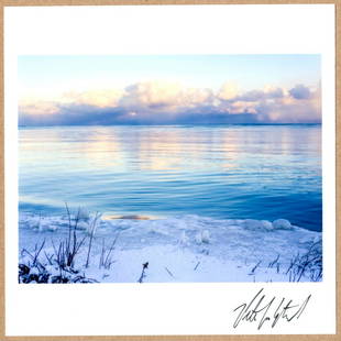
Sold2023SIGNED - PETER VAN AGTMAEL - SUNRISE ON LAKE HURON LTD 6" x 6" MAGNUM PRINT.Description: 6"x 6" limited edition Fuji Crystal Archival Matte paper print. Image size is 5.5" on the longest side and the paper size is 6" x 6". The Print is SIGNED by Peter Van Agtmael on the rectoSee Sold Price
Sold2018GREAT LAKES. Upper Canada districts <1849 Lake HuronTITLE/CONTENT OF MAP: 'NORTH AMERICA, SHEET III., Upper Canada and New Brunswick with parts of New York, Pennsylvania and Michigan' The map shows the historic districts of Upper Canada (Ontario) as thSee Sold Price
Sold2019Map Provinces of Canada 1862 JohnstonPROVINCE OF CANADA Nice coloured map of Provinces of Canada (British colony Wellington, Lake Huron, Georgian Bay, Victoria of 1862 circa. Author: W. & A. K. Johnston Date: 1862 circa Technique: CopperSee Sold Price
2018Big coloured map of Provinces of Canada 1862, CopperNice coloured map of Provinces of Canada (British colony Wellington, Lake Huron, Georgian Bay, Victoria) of 1862 circa. Author: W. & A. K. Johnston Date: 1862 circa Technique: Copper etching Leaf DimeSee Sold Price
Sold2022Weekly Dispatch C1860 Lot of 6 Large British MapsIncl Lake District, Worcestershire/Gloucestershire, Cumberland/Westmoreland, Durham, Wiltshire, and Bedforshire. Lithograph Maps Published C1860, London for "The Dispatch Atlas" and/or "The Weekly DisSee Sold Price
Sold20246 Decorative Old Maps of 16th-18th CenturiesSet of six vintage "Decorative Old Maps of 16th, 17th, 18th Centuries" including colored maps of Europe, The Holy Land, Asia, Belgium, and Canada and the Great Lakes. [Sheets: 16" H x 20" W]. In goodSee Sold Price
Sold2017Cary: US Western Territory/Great Lakes Region Map, 1805Map: A New Map of Part of the United States of North America, exhibiting the Western Territory, Kentucky, Pennsylvania, Maryland, Virginia &c., also the lakes Superior, Michigan, Huron, Ontario & ErieSee Sold Price
Sold20191857 Colton Map of Brazil -- Brazil and GuayanaTitle/Content of Map: 1857 Colton Map of Brazil -- Brazil and Guayana Date: 1855, New York Cartographer: J Colton Size: 16 X 12.6 in. This rather nice map shows plenty of topographical, river, lake, tSee Sold Price
Sold2023A Grouping of 17th & 18th Century Old World Maps Lot of 6Lot Includes: The English Channel, A Map of France, North American Rivers and Lakes Between Superior and Slave Lake (2), A New map of Russia in Europe, & Nouvelle Carte Du Royaume de Bengale EngraSee Sold Price
Sold2023Lot of 5 Nautical PrintsThree photos of sailboats/sailing, one schematic drawing of a Great Lakes sailboat, and a nice map of Beaver Island (Lake MNichigan), in a rustic barnwood frame. See PicsSee Sold Price
Sold2024WINDERMERE LAKE, SCROLLING PANORAMA, 1889WINDERMERE LAKE, SCROLLING PANORAMA, 1889 Printed map on linen, measuring approx. 400 x 1440mm, hand-coloured, with a scale of 6 inches to a Statute Mile. Housed in the original glazed wooden cabinet,See Sold Price
Sold20241906 True Bearing of Celestial Objects for The Great Lakes Book and 1957 The Heavens Map FromA pair of celestial nautical navigation items including an April 1906 Azimut or True Bearing of Celestial Objects for The Great Lakes From Latitude 41? to 49? Inclusive with Maps by Frank Henrich. TheSee Sold Price
Sold20216 Lake Champlain Steamship China Soup BowlsSet of 6 ca. 1920 Lake Champlain Transportation Company sidewheeler Steamboat Vermont and Ticonderoga Syracuse China restaurant porcelain soup bowls, featuring nautical crest, overall very good conditSee Sold Price
Sold2022Nautical, Sailing and Navigation Books (7)Seven hardback sailing, piloting, navigation and boat handling related books including DUTTON'S Naval Institute Press. Approx. 10" to 12" tall. In age appropriate condition, see photos.See Sold Price
Sold2016S. Hall: Map of Mexico 1844Map: Mexico Maker: S. Hall Size: 10 x 14.6 inches With the Republic of Texas having a long NW arm reaching as far north as the Great Salt Lake. Original outline color. Please note that this lot has aSee Sold Price
Sold2018Early American Map of North American IndiansWanderings and Locations of the Aborigines Map showing the Atlantic Ocean as a "Salt Water Lake". North American Indians. Maker: E. F. Waitt Dated:See Sold Price
Sold2017Gentleman’s Magazine Map of the New Continent, 1758Map: A Map of the New Continent according to its greatest diametrical Length from the River la Plata to beyond the Lake of the Assiniboits Maker: Gentleman's Magazine Place & Date: London / 1758 Size:See Sold Price
Sold2018Bartholomew: Antique Map of England & Wales, 1890Title/Content of Map: England & Wales Date Printed: 1890 Cartographer: BARTHOLOMEW, JOHN & CO. Size (inches): 11.25X11.6 "By J. Bartholomew, F.R.G.S." Polar projection. 11 Shows nautical routes. FromSee Sold Price
Sold2017Sailing the Great Lakes & Rivers of America 1855Sailing on the Great Lakes and Rivers of America, J. Disturnell, 284 pages, Philadelphia, 1874. With fold out map in end matter, frontis, gilt, faded red cloth. 7.5" X 6".See Sold Price
Sold2018Two Maps - Duttons, NY and Essex, NJA Map Showing The New Locale of Dutton, Inc. 270 Park Avenue. 20" x 15"; South Moutain Reservation Essex County Park System map, 1937. 13" x 26"See Sold Price
Sold2024Arthur Lismer (1885-1969) Canadian, Ink DrawingArthur Lismer (1885-1969) Canadian, ink drawing titled: “Georgian Bay” off Lake Huron. Provenance: Comes from the important ex board member of the Ontario Museum of Art. His purpose and goal wSee Sold Price
3 days LeftForum AuctionsAngling.- Minhinnick (Sir Gordon Edward George) Collection of 14 original illustrations and 20£400
1 day LeftJasper521552 Munster Map of Southern Germany and Switzerland -- Suevia et Bavaria XII Nova Tabula$160
Jun 07Freeman's | Hindman[MAPS]. HOMANN, Johann Baptist, HOMANN HEIRS, and Georg Matthäus SEUTTER. [Composite Atlas].$15,000
Jun 30JM Hobby Supply and Railroad Artifact AuctionsWheeling and Lake Erie RTR 2-6-6-2 Steam Loco #8007-Bachmann Spectrum-N Scale$20


![7 Collectible Maps - Lake Huron - Georgian Bay: Lake Huron Canada. Georgian Bay. French / English. [LA 4529]](https://p1.liveauctioneers.com/6288/141133/71496657_1_x.jpg?height=310&quality=70&version=1556635288)


![6 Decorative Old Maps of 16th-18th Centuries: Set of six vintage "Decorative Old Maps of 16th, 17th, 18th Centuries" including colored maps of Europe, The Holy Land, Asia, Belgium, and Canada and the Great Lakes. [Sheets: 16" H x 20" W]. In good](https://p1.liveauctioneers.com/1221/316726/170695118_1_x.jpg?height=310&quality=70&version=1706931805)


![[MAPS]. HOMANN, Johann Baptist, HOMANN HEIRS, and Georg Matthäus SEUTTER. [Composite Atlas]. (1 of 5)](https://p1.liveauctioneers.com/197/329395/177650530_1_x.jpg?height=282&quality=70&version=1715364962)


