Sold2021Antique Diagrammatic Road Map of Central EuropeAntique Framed Diagrammatic Road Map of Central Europe by Wood McMurtry. Measures 22 inches high by 28 inches wide.See Sold Price
Sold2018Bonne: Antique Map of Central Europe, 1780Title/Content of Map: 'L'Allemagne, La Boheme, et La Hongrie; avec une partie de Pologne'. A map of Central Europe from the Baltic Sea to the Gulf of Venice, including present day Germany, Poland, CzeSee Sold Price
Sold2019Rail Road Map of Central EuropeTitle: Rail Road Map of Central Europe Publication Date: 1870-08-25 Cartographer: ANONYMOUS Publisher: THE ADVANCE [NEWSPAPER] Dimension: 14.5Height - 20.5Width as adopted by the Prussian Military AutSee Sold Price
Sold2017Mclellan: Antique Map of Central & Southern Europe 1855Map: Central & Southern Europe Publication Date: 1855 Authors: HARPER & BROTHERS, MCLELLAN, D. Publisher: HARPER & BROTHERS Size: Folio – 15.10 H x 17.10 W Inches To illustrate Harper's Gazetteer. FSee Sold Price
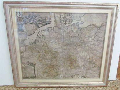
Sold2019Pomerania Central Europe Antique MapDucatus Pomeraniae. Hand-colored engraved map. J.B. Homann, Nuremberg, 18th C.. 21" x 24".See Sold Price
Sold2018Cornell: Antique Map of West, Central & South EuropeTitle/Content of Map: Western, Central & Southern Continental Europe. Date Printed: 1857 Cartographer: CORNELL, SARAH SOPHIA Publisher: D. APPLETON 1857 NEW YORK Size: Folio – 12.60 H x 20.30 W InchSee Sold Price
Sold2023Antique Map Print - Europe - Map of Silesia - Poland - Czech Republic - WroclawDescription: Map of Silesia. Silesia is a historical region of Central Europe that lies mostly within Poland, with small parts in the Czech Republic and Germany. Date: 17th Century Material: Paper DimSee Sold Price
Sold2017Smith: Antique Map of Asia, 1894Map: 1894 Smith Map of Asia [verso] South Central Europe -- Map of Asia Showing its Geopolitical Divisions, and also the Various Routes of Travel between London & India, China & Japan &c. [verso] AustSee Sold Price
Sold2023Reclus, Elisee C1880 Lot of 6 Antique Maps of EuropeIncl Belgium/Netherlands, Scandinavia, British Isles, Volcanoes of Central France, Russia, and Central Europe. Lithograph Map Published 1876-94, London for "The Universal Geography" by Elisee Reclus.See Sold Price
Sold2023Meyer, Joseph 1898 Mixed Lot of 9 Antique MapsIncl Ornithology Map, Central Europe, German Republic, West Indies, Winds, Historical and Classical Maps and others. Lithograph Maps Published 1893-98, Leipzig and Vienna for "Meyers Konversations-LexSee Sold Price
Sold2022EUROPE & MEDITERRANEAN. Relief. Railways. Shipping routes. BARTHOLOMEW 1912 mapTITLE/CONTENT OF MAP: 'Central Europe and The Mediterranean' DATE PRINTED: 1912 IMAGE SIZE: Approx 33.5 x 44.5cm, 13.25 x 17.5 inches (Large); Please note that this is a folding map. TYPE: Antique colSee Sold Price
Sold2022Transport Map of Central Europe. Railways mail routes. LARGE 1959 oldTITLE/CONTENT OF MAP: 'Transport Map of Central Europe' DATE PRINTED: 1959 IMAGE SIZE: Approx 49.5 x 72.0cm, 19.5 x 28.25 inches (Large); Please note that this is a folding map. TYPE: Antique colour mSee Sold Price
Sold2024Central Europe roads canals railways Germany, Holland & Belgium. HUGHES 1854 mapCAPTION PRINTED BELOW PICTURE: 'Map of Central Europe, embracing Germany, Holland, Belgium, with parts of France & Switzerland; showing the roads, canals and railways' DATE PRINTED: 1854 IMAGE SIZE: ASee Sold Price
Sold20171906 wall hanging maps1906 wall hanging maps published by The World and its Leaders Farm and Fireside- The National Farm Magazine. Maps include United States and Alaska; Stains; Central Europe. Maps are not individual mapsSee Sold Price
Sold2024Antique Map of Black Sea - John Rapkin - Europe - Asia - Turkey, Romania, Bulgaria, Ukraine"Black Sea". Fine map of the Black Sea, with an elaborate decorative border. The map shows eastern Europe and central Asia, including Turkey, Romania, Bulgaria, Ukraine, Russia, and Georgia.See Sold Price
Sold2017Bellin: Antique Maps of Central Asia / Silk Road, 1749Map: 1. Carte de Karazm, Turkestan et Grande Bukarie. 2. Carte de la Petite Bukharie et Pays Voisin Cartographer: Jacques Nicolas Bellin Place & Date: Paris / 1749/1760 Size: 12" x 8 1/2" (each) CondiSee Sold Price
Sold20231769 ANTIQUE MAP of EUROPE framed EUROPEAN POSTAL ROADS & STATIONS1769 ANTIQUE MAP: MAPPA GEOGRAPHICA EXHIBENS POSTAS omnes tam vehiculares quam verdarias Totius Germaniae cum earum accurata distantia Diligentissime propriis sumptibus excudit. Aug. Vindelicor. : TobSee Sold Price
Sold2022Antique Map of Europe - County Map of Glamorganshire - Wales - United KingdomAntique map of Glamorganshire. Place names, topography, roads and railways are shown in significant detail by Joshua Archer. 'The Universal English Dictionary ...' by Rev. James Barclay, published inSee Sold Price
Sold2022Antique Map of Europe - County Map of Huntingdonshire - Wales - United KingdomAntique map of Huntingdonshire. Place names, topography, roads and railways are shown in significant detail by Joshua Archer. 'The Universal English Dictionary ...' by Rev. James Barclay, published inSee Sold Price
Sold2022Antique Map of Europe - County Map of Herefordshire - Wales - United KingdomAntique map of Herefordshire. Place names, topography, roads and railways are shown in significant detail by Joshua Archer. 'The Universal English Dictionary ...' by Rev. James Barclay, published in LSee Sold Price
Sold2020AN ANTIQUE MAP, "Europe (Evrop)," JOHN SPEED,AN ANTIQUE MAP, "Europe (Evrop)," JOHN SPEED, CARTOGRAPHER, 1626-1676, hand-colored engraving on paper, Abraham Goos (1589-1643), engraver, published for merchants Thomas Basset and Richard Chiswell iSee Sold Price
Sold2021de Fer, Nicolas 1717 Antique Map. Europe"L'Europe Suivant les Nouvelles Observations" Copper Engraved Map Published 1717, Paris for "Introduction a la Geographie" by Nicolas de Fer. Folds as issued. Paper Size: 14 x 10 inch (36 x 25cm) GoodSee Sold Price
Sold2024Antique Map - Europe - Italy With the Islands of Sicily, Corsica and SardiniaMap of iItaly with the islands of Sicily, Sardinia and Corsica by Francois Halma, 1700. Decorative large map of Italy, with an elaborate cartouche.See Sold Price
Sold2022Butler, Samuel 1842 Antique Map. EuropeSteel Engraved Map Published 1842, London for "An Atlas of Modern Geography" by Samuel Butler. Drawn & Engraved by Sidney Hall. Centre fold as published. Original outline hand colour. Paper Size: 10.5See Sold Price
Jun 09Worthington GalleriesAntique H/C Map EUROPE SOUS CHARLEMAGNE EN 814: EMPIRES D'OCCIDENT ET D'ORIENT$25
5 days LeftJasper521775 d'Anville Map of Middle Ages Europe -- Germany, France, Italy, Spain, British Isles, In an$70
8 hrs LeftPandora AuctionsAntique European Arts & Crafts Stainless Steel, Wood & Green Enamel Cigarette Box$130(3 bids)
8 hrs LeftPandora AuctionsVery Rare Antique Victorian 18K Gold, Enamel & Human Hair Braidwork Pocket Watch Winding Key$250
8 hrs LeftPandora AuctionsAntique Art Nouveau European Blue Opal Glass & Floral Metal Base Centerpiece$75
8 hrs LeftPandora AuctionsAntique Art Deco European Sterling Silver & Gemstone Venice Gondola Scene Cigarette Case$200
8 hrs LeftPandora AuctionsRare Antique Early 19th Century European Porcelain & Brass Mantel Clock$350
4 hrs LeftNY Elizabeth TRAVELS IN CENTRAL ASIA BY ARMINIUS VALLERY, 1864, WITH AN ANTIQUE MAP$50(1 bid)
8 hrs LeftPandora AuctionsAntique ca. 1880 European 14K Gold & Shell Cameo "Chariot with Putto" Brooch$75
8 hrs LeftPandora AuctionsUnusual Antique ca. 1930s European 18K Gold & Shell Cameo "Castle" Brooch / Pendant$150
6 days LeftJasper52Colonial Central Africa. Belgian Congo. French Equatorial Africa. TIMES 1922 map$15
6 days LeftJasper52World War 2 Europe Battle of the Atlantic 1939-43 Axis Expansion limits 1959 map$15


![Rail Road Map of Central Europe: Title: Rail Road Map of Central Europe Publication Date: 1870-08-25 Cartographer: ANONYMOUS Publisher: THE ADVANCE [NEWSPAPER] Dimension: 14.5Height - 20.5Width as adopted by the Prussian Military Aut](https://p1.liveauctioneers.com/5584/153795/77648689_1_x.jpg?height=310&quality=70&version=1572992559)


![Smith: Antique Map of Asia, 1894: Map: 1894 Smith Map of Asia [verso] South Central Europe -- Map of Asia Showing its Geopolitical Divisions, and also the Various Routes of Travel between London & India, China & Japan &c. [verso] Aust](https://p1.liveauctioneers.com/5584/108292/55552449_1_x.jpg?height=310&quality=70&version=1503667951)