Sold2023Baines, Edward 1817 Antique Map. Germany"Map of Germany as designed by the treaty of Paris concluded May 30th 1814" Copper Engraved Map Published 1817, London for "History of the Wars of the French Revolution..." by Edward Baines. Folds asSee Sold Price
Sold2023Baines, Edward 1817 Antique Map. USA & Canada, War of 1812"United States of America Exhibiting the Seat of War on the Canadian Frontier" Copper Engraved Map Published 1817, London for "History of the Wars of the French Revolution..." by Edward Baines. FoldsSee Sold Price
Sold2023Baines, Edward 1817 Antique Map. Egypt and Part of SyriaWood Engraved Map (Reverse side blank) Engraved Map Published 1817, London for "History of the Wars of the French Revolution..." by Edward Baines. Paper Size: 10 x 8 inch (25 x 20cm) Very minor toningSee Sold Price
Sold2023Baines, Edward 1817 Antique Map. Battle of the Nile, EgyptWood Engraved Map (Reverse side blank) Published 1817, London for "History of the Wars of the French Revolution..." by Edward Baines. Paper Size: 10 x 8 inch (25 x 20cm) Very minor toning. Good ConditSee Sold Price
Sold2023Baines, Edward 1817 Antique Map. Italy with the Alpine FrontierCopper Engraved Map Published 1817, London for "History of the Wars of the French Revolution..." by Edward Baines. Paper Size: 10 x 8 inch (25 x 20cm) Very minor toning. Good ConditionSee Sold Price
Sold2023Baines, Edward 1817 Antique Map. Egypt and Part of SyriaWood Engraved Map (Reverse side blank) Published 1817, London for "History of the Wars of the French Revolution..." by Edward Baines. Paper Size: 10 x 8 inch (25 x 20cm) Very minor toning. Good ConditSee Sold Price
Sold2023Baines, Edward 1817 Antique Map. Spain and PortugalWood Engraved Map (Reverse side blank) Published 1817, London for "History of the Wars of the French Revolution..." by Edward Baines. Folds as issued. Paper Size: 12 x 10 inch (30 x 25cm) Very minor tSee Sold Price
Sold2023Baines, Edward 1817 Antique Map. Europe according to the Treaty of Vienna"Chart Illustrative of the Campaigns of the Wars of the French Revolution" Copper Engraved Map Published 1817, London for "History of the Wars of the French Revolution..." by Edward Baines. Folds as iSee Sold Price
Sold2023Baines, Edward 1817 Antique Map. Spain and PortugalWood Engraved Map (Reverse side blank) Published 1817, London for "History of the Wars of the French Revolution..." by Edward Baines. Folds as issued. Paper Size: 12.5 x 10 inch (32 x 25cm) Very minorSee Sold Price
Sold2023Baines, Edward 1817 Antique Map. French EmpireCopper Engraved Map Published 1817, London for "History of the Wars of the French Revolution..." by Edward Baines. Folds as issued. Paper Size: 12.5 x 10 inch (32 x 25cm) Some toning, otherwise fineSee Sold Price
Sold2023Baines, Edward 1817 Antique Naval Map. Battle of TrafalgarWood Engraved Map (Reverse side blank) Published 1817, London for "History of the Wars of the French Revolution..." by Edward Baines. Paper Size: 10 x 8 inch (25 x 20cm) Very minor toning. Good ConditSee Sold Price
Sold2019Wells, Edward 1817 Antique Map of EuropeCopper Engraved Map Published 1817, London for "A Companion to the Holy Bible; The Sunject, Sacred Geography..." by Edward Wells. Paper Size: 10.5 x 8 inch (27 x 21cm) Good ConditionSee Sold Price
Sold2019Wells, Edward 1817 Antique Map of AsiaCopper Engraved Map Published 1817, London for "A Companion to the Holy Bible; The Sunject, Sacred Geography..." by Edward Wells. Paper Size: 10.5 x 8 inch (27 x 21cm) Good ConditionSee Sold Price
Sold2019Wells, Edward 1817 Antique Map of AfricaCopper Engraved Map Published 1817, London for "A Companion to the Holy Bible; The Sunject, Sacred Geography..." by Edward Wells. Paper Size: 10.5 x 8 inch (27 x 21cm) Good ConditionSee Sold Price
Sold2018Thomson: Antique Map of Southern Germany, 1817Title/Content of Map: 'Germany, south of the Mayne'. This large, decorative map shows Southern Germany, including the Kingdom of Bavaria, Hesse-Darmstadt, the Grand Duchy of Baden, the Kingdom of WurtSee Sold Price
Sold2024Swire & Hall 1824 Antique Map. Rochdale, LancashireSteel Engraved Map Published 1824-25, Liverpool for "The History, Directory and Gazetteer of the County Palatine of Lancaster?" by Edward Baines. Engraved by Sidney Hall after William Swire. Paper SizSee Sold Price
Sold2019"Germany, north of the Mayne" (Main). Prussia HanoverTITLE/CONTENT OF MAP: 'Germany, north of the Mayne' DATE PRINTED: 1817 IMAGE SIZE: Approx 53.5 x 65.0cm, 21 x 25.75 inches (Large); Please note that this is a folding map. TYPE: Antique early 19th cenSee Sold Price
Sold2018"View of the University of Virginia" Panoramic MapVIEW OF THE UNIVERSITY OF VIRGINIA, CHARLOTTESVILLE AND MONTICELLO, TAKEN FROM LEWIS MOUNTAIN, drawn and lithographed by Edward Sachse (Maryland/Germany, 1804-1873) and Company and the Sun Iron BuildiSee Sold Price
Sold2019Wells, Edward 1817 Maps of Israel (3) Holy Land"Travels of Israel, in the Wilderness" "A Map of Canaan" "A Map of Canaan, adapted to the Book of Genesis" Copper Engraved Map Published 1817, London for "A Companion to the Holy Bible; The Sunject, SSee Sold Price
Sold2019Antique Map: Germany (Deutschland)Description: Antique Map: Germany (Deutschland), Holstein, Hanover, Mecklenburg, the Prussian States, Saxony. Antique steel engraved map with original outline hand coloring. Date of printing: 1844. CaSee Sold Price
Sold2019Wells, Edward 1817 Map of Asia Showing ParadiseCopper Engraved Map Published 1817, London for "A Companion to the Holy Bible; The Sunject, Sacred Geography..." by Edward Wells. Paper Size: 10.5 x 8 inch (27 x 21cm) Good ConditionSee Sold Price
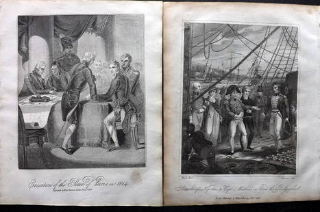
Sold2023Baines, Edward 1817 Pair of Military & Naval Prints"Execution of the Peace of Paris in 1814" and "Surrender of Napoleon to Capt. Maitland£ Copper Plate & Wood Engraving (Reverse side blank) Published 1817, London for "History of the Wars of the FrencSee Sold Price
Sold2023Baines, Edward 1817 Lot of 6 Military/Naval etc PortraitsCopper Plate Published 1817, London for "History of the Wars of the French Revolution..." by Edward Baines. Paper Size: 10 x 8 inch (25 x 20cm) Some toning presentSee Sold Price
Sold2023Baines, Edward 1817 Lot of 6 Copper Engraved PortraitsCopper Plates Published 1817, London for "History of the Wars of the French Revolution..." by Edward Baines. Folds as issued. Paper Size: 12 x 10 inch (30 x 25cm) Some toning, otherwise fineSee Sold Price
2 days LeftJasper52COLONIAL AFRICA. British French German Italian Portugal Spain.STANFORD 1906 map$15
1 day LeftJasper52Oil Painting 3 Hunting Terrier Dogs "A Sharp Lookout" Edward Armfield 1817-1896$2,600
2 days LeftJasper52Colonial Southern Africa. British Portuguese German. Madagascar. TIMES 1900 map$15
Featured2 days LeftJasper52CENTRAL AFRICA. French Congo German east British Angola Tanzania. BACON 1893 map$15
2 days LeftJasper52Colonial Southern Africa. British Portuguese German. Madagascar. TIMES 1895 map$20
Featured2 days LeftJasper52Colonial West Africa. Nigeria Cameroon Congo. British German. TIMES 1900 map$20
2 days LeftJasper52Colonial Africa. British German French Spanish Portuguese Italian TIMES 1900 map$35
2 days LeftJasper52COLONIAL CENTRAL AFRICA. Congo German East Africa Rhodesia. BARTHOLOMEW 1898 map$40
Featured2 days LeftJasper52Colonial Africa. British German French Spanish Portuguese Italian TIMES 1895 map$40
Featured2 days LeftJasper52Africa. Mauritius, Bourbon (Reunion) & Natal by Edward Weller 1860 old map$55
2 days LeftJasper52Central Africa. Congo Free State Rhodesia German East Africa. STANFORD 1904 map$220
Featured2 days LeftJasper52Central Africa. Congo Free State Rhodesia German East Africa. STANFORD 1896 map$280
2 days LeftJasper52Central Africa. Congo Free State Rhodesia German East Africa. STANFORD 1894 map$280
2 days LeftJasper52NORTH AFRICA OF BABRBARY V Parts of Tripoli & Egypt. Libya Tribes. SDUK 1846 map$15