Sold2018Benard: Magellan Strait with Coastal ProfilesA large-scale dramatic chart of the Magellan Strait with extensive coastal detail and four coastal profiles, based on the observations and discoveries of Captains Byron, Wallis, and Carteret.; G642; BSee Sold Price
Sold2024Benard Direxit - engraving of Islands around Tonga coastal profiles -1773Coastal views of Sir Charles Saunders Island, Osnaburg Island, Boscawens Island, Admiral Keppel's Island, Wallis Island - 1773Size 32,5 x 35,5See Sold Price
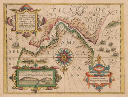
Sold2024Antique Map - South America - Chart of Strait of Magellan - Patagonia - ChileThis large, original copper engraved, antique map, a chart of the Straits of Magellan, South America and the Patagonian & South Chilean shoreline was engraved by Robert Benard and published in theSee Sold Price
Sold2017Linschoten: Coastal Profiles St. Helena Island, 1596Map: Vera effigies et delineatio Insulae Sanctae Helenae Cartographer: Linschoten Place & Date: Amsterdam / 1596 Size: 18 3/4" x 12 1/4" Condition: b&w; folds as issued and some creasing; left, rightSee Sold Price
Sold2023Détroit de Magellan. Strait of Magellan. Chile. BONNE 1790 old antique map[Voyage des Capitaines Byron, Vallis et Carteret] Détroit de Magellan avec les Plans des principaux Ports, Bayes &c. de ce Détroit // Havre Swalow ou de l'Hirondelle // Baye du Cap Upright // BaSee Sold Price
Sold2019Moore: Bougainville Claims Magellan Strait for FranceMap Title: M. Bougainville hoisting French Colours on a small Rock, in Magellan Streights Cartographer: Moore / Hogg / Vangro / Royce Place/Date: London / 1778 Size: 6 3/4" x 11" Condition: b&w; lightSee Sold Price
Sold2022The Atlantic Coast Pilot (1878)A copy of The Atlantic Coast Pilot. Boston Bay to New York. By the United States Coast Survey. (Washington, D.C., 1878). With many engraved folding plates of coastal profiles and harbor charts.See Sold Price
Sold20201794 English Pilot: Description of the Caribbee IslandsTitle/Content of Map: 1794 English Pilot: Description of the Caribbee Islands Date Printed: 1794, London Cartographer: Mount and Davidson Size: 12 1/4" x 18 3/4" Two pages of coastal profiles of (on tSee Sold Price
Sold2019Cochin: Canary Is. Coastal Views/Tenerife, GomeraCoastal profiles of the Canary Islands of Tenerife and Gomera on a single sheet from the German edition of Prevost d'Exiles' collection of travel narratives, Histoire Generale des Voyages.; Cochin / JSee Sold Price
Sold2018Mount & Page: Antique Map of Levant coast, 1747TITLE/CONTENT OF MAP: 'Prospects of the land upon the coasts of Cyprus and Syria' The following places are shown or referred to on the coastal profile chart: Baruti (Beirut) Sidon Cape Porcos AntiochiSee Sold Price
Sold2017Mount & Page: Antique Coast Profile Ionian Islands 1747How these lands appear at sea' Ionian islands coast profile. The following places are shown or referred to on the coastal profile chart: Corfu Fanu Pachsu (Paxos) Antipaschu (Antipaxos) Marco ZephelonSee Sold Price
Sold2017Mount & Page: Antique Coast Profile of Ireland, 1749Title/Content of Map: '[A description of the sea coast of Ireland]' The following places are shown or referred to on the coastal profile chart: Galloway (Galway) Aran Islands Limerick Date Printed: 17See Sold Price
Sold2017Mercator: Strait of Magellan, Terra del Fuego, 1613Exquisita & magno aliquot mensium periculo Lustrata et iam retecta Freti Magellanici Facies . . . By: Gerard Mercator. Date: 1613 / Amsterdam. Dimensions: 14 x 18 inches (35.5 x 45.7 cm) This is an auSee Sold Price
Sold2016Strait of Magellan, Jodocus Hondius 1606-33Title: Freti Magellanici ac novi Freti vulgo Le Maire Subject: Strait of Magellan Maker: Jodocus Hondius Date: 1606-33, Amsterdam Size: 15.1 x 19.25 inches This is one of the best known early maps ofSee Sold Price
Sold2022Large chart of Strait of Magellan 1787Heading: (South America) Author: Schraembl, Franz Anton Title: Karte der Magellanischen Strasse von Herrn Don Iuan de la Cruz Cano y Olmedillo... Place Published: Wien Publisher:Jos. Gerstner DatSee Sold Price
Sold2019Strait of Magellan Map[Strait of Magellan Map] , "Fretum Magellannicum", by Theodore De Bry, Frankfurt, 1601, copper engraved, depicting ships, natives, a penguin and a snail, 6 1/2 in. x 11 3/4 in., framed IMPORTANT: AllSee Sold Price
Sold2023J. DE HONDT, COLOR MAP OF STRAITS OF MAGELLANJoost de Hondt (Belgian 1563-1612), "Freti Magel Lanici Ac Novi Freti Vulgo, Le Maitre Exactissima Delineatio", hand colored map of the Straits of Magellan, Le Maire Strait, Fire Lands and the southerSee Sold Price
Sold2023Lot of 3 Books by Rockwell Kent, Voyaging The Strait Of Magellan 1924, Salamina 1935, N by E 19351) Voyaging Southward From The Strait Of Magellan, with illustrations by the Author. Published by Halcyon House, New York 1924, Fourth Printing. Good condition. 2) Salamina, illustrated by the Author.See Sold Price
Sold2022Strait of Magellan from French Cook 1778Heading: (South America) Author: Bernard, Jean Frederic Title: Carte du Detroit de Magellan dans laquelle on an Insere les Observations et les Decouvertes du Capne. Byron, du Capne. Wallis, et du CapnSee Sold Price
Sold2018Bellin: Chart of the Strait of Magellan 1760Map: Carte Reduite du Detroit de Magellan Cartographer: Bellin Place & Date: Paris / 1753/1760 Size: 13 1/2" x 9" Condition: b&w; old fold; margins extended with contemporary paper to fit the size ofSee Sold Price
Sold2017VOYAGING SOUTHWARD FROM THE STRAIT OF MAGELLANBy Rockwell Kent, 1924. Filled with illustrations by the author. Ht. 29 cm. (11 1/2 in.) Approx. weight 1.1 kg.See Sold Price
Sold2020STRAITS of MAGELLAN & TIERRA DEL FUEGO calledTitle: STRAITS of MAGELLAN & TIERRA DEL FUEGO called MAGELLANICA, with Cape Horn Date/Period: 1642-1665 Materials: Copperplate engraved Size: 18 1/4 x 21”. Maps shows the southern most tip of SouthSee Sold Price
Sold20241756 Straits of Magellan, Cape Virgin Mary, Patagonia, by G. AnsonTitle: 1756 Straits of Magellan, Cape Virgin Mary, Patagonia, by G. Anson Date/Period: 1756 Materials: Copper plate engraved Size: 17 x 11 ? This 1756 map depicts Cape Virgin Mary, the north entranceSee Sold Price
Sold2023GROUP OF 5 HAND COLORED MAPS OF THE AMERICASGroups of five hand colored antique maps of the Americas, comprising "America Merioio-Nalis (South American)" circa 1620, "Tabula Magellanica Qua Tierre Del Fuego (Strait of Magellan)" circa 1640, "IlSee Sold Price
5 days LeftJasper52Détroit de Magellan. Strait of Magellan. Chile. BONNE 1790 old antique map$30
5 days LeftJasper52Détroit de Magellan. Strait of Magellan. Chile. BONNE 1788 old antique map$30
5 days LeftJasper52Extremité Meridionale de l'Amérique Tierra del Fuego Magellan Str BONNE 1788 map$35
Jun 01Northgate Gallery, Inc.Mid-Century Hand Woven Needlepoint Wall Tapestry Depicting European Coastal Fish Market Scene$275(4 bids)
3 days LeftDonny Malone AuctionsRobert Angeloch 1922-2011, Large Size Oil on Board Painting Abstract Coastal Landscape, Unsigned$10(1 bid)
Crawford Family Auctions LLC44 pcs Vintage Fly Fishing Tools & Accessories Assortment. Magellan GPS 4000 XL. Shakespeare. See$20(1 bid)
201 Lots AwayEldred'sALFRED BIRDSEY (Bermuda, 1912-1996), Coastal landscape, Bermuda., Watercolor on paper, 14.25" x 17"$175(2 bids)
6 days LeftNye & CompanyOil on Canvas of Sailing Ship on New England Coastal Scene James Souden$30(2 bids)
Jun 01Link Auction GalleriesSarkis Erganian, Missouri, New York / Turkey, Russian Federation (1874-1950), Coastal Scene, oil on$75
Jun 02Tremont AuctionsJoseph Mellor Hanson. 1956. Matinicus Island, Maine. "Matinicus and Her Satelites". Coastal seascape$200
Jun 01Link Auction GalleriesSarkis Erganian, Missouri, New York / Turkey, Russian Federation (1870-1950), Coastal Scene, oil on$75
22 hrs LeftMichael's GalleryRalph Baker (Impressionist - Coastal Seacape) Signed Original Watercolor$500


![Détroit de Magellan. Strait of Magellan. Chile. BONNE 1790 old antique map: [Voyage des Capitaines Byron, Vallis et Carteret] Détroit de Magellan avec les Plans des principaux Ports, Bayes &c. de ce Détroit // Havre Swalow ou de l'Hirondelle // Baye du Cap Upright // Ba](https://p1.liveauctioneers.com/5584/294908/156576972_1_x.jpg?height=310&quality=70&version=1688565030)


![Mount & Page: Antique Coast Profile of Ireland, 1749: Title/Content of Map: '[A description of the sea coast of Ireland]' The following places are shown or referred to on the coastal profile chart: Galloway (Galway) Aran Islands Limerick Date Printed: 17](https://p1.liveauctioneers.com/5584/110608/56777156_1_x.jpg?height=310&quality=70&version=1507840413)


![Strait of Magellan Map: [Strait of Magellan Map] , "Fretum Magellannicum", by Theodore De Bry, Frankfurt, 1601, copper engraved, depicting ships, natives, a penguin and a snail, 6 1/2 in. x 11 3/4 in., framed IMPORTANT: All](https://p1.liveauctioneers.com/268/150890/76180328_1_x.jpg?height=310&quality=70&version=1569336980)


