Sold202217th Century Willem Blaeu Wall MapA number of losses to map have been filled-in, albeit mostly marginal and without information loss (upper margin, top-left corner, lower-right corner). Filled-in portion towards left margin, touching-See Sold Price
Sold2020Framed Blaeu Wall Map Gold FoilFramed Blaeu Wall Map Gold Foil Roughly 25.5" x 32"See Sold Price
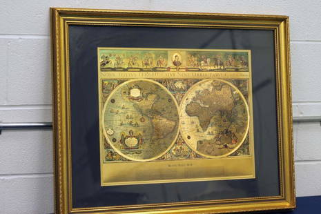
Sold2024Blaeu Wall MapNova Totivs Terrarom Sive Novi Orbis Tabvla and G. Blaeu. Sight: 15-1/2" high x 19-1/2" wide. Overall with frame: 18" high x 22" wide. LRSee Sold Price
Sold20172 Framed World Maps including Blaeu Wall Map2 Framed World Maps including Blaeu Wall Map. Largest measures 22 x 26 inches.See Sold Price
Sold2021Framed World MapFramed World map, Blaeu wall map, color print with areas of silvered paper, double matted in mahogany finish 25" x 29" frame. Condition; very goodSee Sold Price
Sold20151845 MITCHELL'S REFERENCE & DISTANCE WALL MAP U.S.SHOWING MITCHELL'S 1845 REFERENCE AND DISTANCE WALL MAP OF THE UNITED STATES WITH GENERAL MAP OF THE US WITH CONTIGUOUS BRITISH AND MEXICAN POSSESSIONS.PHILADELPHIA : S. AUGUSTUS MITCHELL COPPER-ENGRASee Sold Price
Sold2024Willem Blaeu, Map of The AmericasAmsterdam, 1617. Together with "Early Maps" by Tony Campbell, Abbeville Press and "The United States in Old Maps and Prints, Eduard Van Ermen. 3 pieces Sight size: 16-1/2"h x 22"w Overall: 23-1/2"h xSee Sold Price
Sold2019Wilem J. Blaeu mapWilem J. Blaeu (Dutch 1571-1638)- Americae Nova Tabula- engraved map with hand-coloring, ca. 1633. 16 1/4 x 21 1/2''See Sold Price
Sold2017Blaeu Map of BrazilMaritima Brasiliae Universa. Joan Blaeu (1596-1673). Engraved map with original color in part. Amsterdam: Blaeu, 1647. 21 x 24 1/2 inches sheet, 32 1/2 x 36 inches framed. This separately issued and rSee Sold Price
Sold20221659 Blaeu Map of Norway -- Norvegia Regnum, vulgo Nor-RykeTitle: 1659 Blaeu Map of Norway -- Norvegia Regnum, vulgo Nor-Ryke Cartographer: J Blaeu Year / Place: 1659 c., Amsterdam Map Dimension (in.): 16.2 X 19.3 in. This is the first large, folio size separSee Sold Price
Sold2018Blaeu Map of Europe -- Europa Recens DescriptaTitle/Content of Map: Blaeu Map of Europe -- Europa Recens Descripta Date: 1635, Amsterdam Cartographer: W Blaeau Size: 16.1 X 21.9 in. This is a grand, large, classic map of Europe, produced at the gSee Sold Price
Sold2023Scarce 1854 wall map of N. America in exceptional condition, Jacob MonkSurprisingly clean and sound wall map of North America showing significant evolution of territories west of the Mississippi River following the Mexican-American War and during the height of the CalifoSee Sold Price
Sold2022Jacob Monk Wall Map of North America 1860Monk's Standard American Map exhibiting the larger portion of North America Embracing The United States and Territories, Mexico, Central America, including the West India Islands, Canada, New BrunswicSee Sold Price
Sold2018(1635) Blaeu Map: Mappa Aestivarvm Insularum,...Historic Maps Hand-Colored "Mappa Aestivarvm Insularum, alias Barmvdas dictarum..." by Willem J. Blaeu, Amsterdam (1635) Hand-Colored Historic Dutch Map titled: "Mappa Aestivarvm Insularum, alias BarmSee Sold Price
Sold20181859 Clark & Tackabury Antique Connecticut Wall MapTitle/Content of Map: 1859 Clark & Tackabury Connecticut Wall Map -- Clark & Tackabury's New Topographical Map of the State of Connecticut Date Printed: 1859 Philadelphia Cartographer: Clark and TackaSee Sold Price
Sold2017Wall map of Marin County 1892Heading: (California - Marin County) Author: Dodge, George M. Title: Official Map of Marin County, California 1892 Compiled from Records and Surveys Place Published: San Francisco Publisher:Schmidt LaSee Sold Price
Sold2020Colton's 1849 wall map of United StatesHeading: Author: Colton, George Woolworth Title: Map of the United States of America, The British Provinces, Mexico, the West Indies and Central America with part of New Granada and Venezuela Place PSee Sold Price
Sold2023VERY RARE WALL MAP OF THE CITY OF BANGOR,PENOBSCOT COUNTY, MAINE. 1853, Bangor, Maine. "Published Under the Patronage of the City Government Henry F. Walling, Civil Engineer, 81 Washington St. Boston 1853". "S.S. Smith, Publisher 17 West MarSee Sold Price
Sold20211856 Wall Map of Strafford Co., New HampshireBy J. Chace Junr., 1856; Smith & Bartlett Publishers; George C. Peavey, Agent. The central hand-colored reference map portion depicting townships and land owners, with expanded downtown views of SalmoSee Sold Price
1 day LeftFreeman's | Hindman[MAP]. TODESCHI, Pietro. [Nova et Acurata Totius Americae Tabula auct. G.I. Blaeu] America quarta$5,000
Jun 13Swann Auction Galleries(CHINA.) Martino Martini; and Joannes Blaeu. Pecheli Sive Peking, Imperii Sinarum Provincia Prima.$1,500
6 days LeftDan Morphy AuctionsBRUE'S MONUMENTAL WALL MAP OF TEXAS, UPPER CALIFORNIA & MEXICO, C. 1845$500
2 days LeftBrzostek’s Auction Service, Inc.Antique Seneca-Cayuga Wall map 1859 by Arz Dawson, Philadelphia$10
2 days LeftBrzostek’s Auction Service, Inc.Antique Seneca-Cayuga Wall map 1859 by Arz Dawson, Philadelphia$10(1 bid)
Jun 13Swann Auction Galleries(NEW JERSEY.) Group of 3 mid-nineteenth-century wall maps of Garden State counties.$900
1 day LeftHolabird Western Americana CollectionsTrinity County Mines (Wall) Map, 1894, Cowden, Johnson [177508]$250
Jun 13Swann Auction Galleries(NEW JERSEY.) Group of 2 mid-nineteenth-century wall maps of Garden State counties.$600
Jun 13Swann Auction Galleries(TRI-STATE AREA.) A.R. Ohman Map Co. Map Showing 100 Miles Around New York City.$450
Jun 13Swann Auction Galleries(RHODE ISLAND.) Henry F. Walling. Map of the State of Rhode Island and Providence Plantations.$500
Jun 13Swann Auction Galleries(NEW YORK CITY.) Jacob Barnitz Bacon. Pier Map of the City of New York, Surveyed and Drawn for the$19,000
Jun 13Swann Auction Galleries(MAINE.) J.H. Colton; and C.C. Hall. Railroad & Township Map of the State of Maine with Portions$375
Jun 13Swann Auction Galleries(NEW YORK.) David Burr. Map of the State of New York with Parts of the Adjacent Country,$500
Jun 13Swann Auction Galleries(NEW YORK.) Amos Lay. Map of the State of New York with Part of the States of Pennsylvania, New$500
Jun 13Swann Auction Galleries(CONNECTICUT.) William Lester, Jr. Map of New London and Windham Counties in Conn.$600
Jun 13Swann Auction Galleries(WORLD.) Nicolas de Fer. Mappe-Monde ou Carte Generale de la Terre.$1,500
Jun 13Swann Auction Galleries(NEW JERSEY.) William Kitchell; and Robert Pearsall Smith. Topographical Map of the State of New$600
Jun 13Swann Auction Galleries(NORTH AMERICA.) Samuel Augustus Mitchell. New National Map, Exhibiting the United States with the$450


![[MAP]. TODESCHI, Pietro. [Nova et Acurata Totius Americae Tabula auct. G.I. Blaeu] America quarta (1 of 1)](https://p1.liveauctioneers.com/197/329395/177650542_1_x.jpg?height=282&quality=70&version=1715364962)


![Trinity County Mines (Wall) Map, 1894, Cowden, Johnson [177508] (1 of 4)](https://p1.liveauctioneers.com/2699/331495/178785752_1_x.jpg?height=282&quality=70&version=1717094933)

![Jacob Monk 1853 Map of North America [173506] (1 of 11)](https://p1.liveauctioneers.com/2699/331495/178785775_1_x.jpg?height=282&quality=70&version=1717094933)


![[MAP]. ORTELIUS, Abraham. Africae Tabula Nova. 1592. (1 of 2)](https://p1.liveauctioneers.com/197/329395/177650533_1_x.jpg?height=282&quality=70&version=1715364962)


