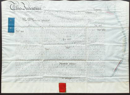
Sold2020British Greywell Indenture Map 1847British land indenture from 1847, ink on vellum, contract between Basingstoke Canal Navigation and the landowner, Baron Dorchester, to do work on the Greywell Canal, a road and tunnel which still exisSee Sold Price
Sold2020Fremont's Narrative with Rufus Sage Map 1847Heading: Author: Frémont, John Charles Title: Narrative of the Exploring Expedition to the Rocky Mountains, in the year 1842; and to Oregon and North California, in the Years 1843-44 Place PublishedSee Sold Price
Sold2022Mitchell's large Mexican-American War map, 1847Heading: Author: Mitchell, Samuel Augustus Title: Map of Mexico, Including Yucatan & Upper California, Exhibiting the Chief Cities and Towns, the Principal Travelling Routes &c. Place Published: PhilSee Sold Price
Sold2021Scarce 1700s British Map of the East IndiesCreator: Edward Wells (British, 1667-1727). Based on map by Nicholas de Fer (1646-1720). Engraver: Sutton Nicholls (British, 1668-1729). Title: "A new map of the East Indies, taken from Mr. de Fer's mSee Sold Price
Sold2018BARNES Samuel John (British. 1847 - 1901)Oil on mahogany panel, mountain landscape scene. Signed lower right. Given the title "In the Tyrol, Hochsolden" Image size: 23 x 31 cm. (9 x 12 in.) Frame size: 36 x 45 cm. (145 x 18 in.) Image size:See Sold Price
Sold2021BRITISH MAP OF ENGLAND AND WALES NEEDLEWORK SAMPLERBRITISH MAP OF ENGLAND AND WALES NEEDLEWORK SAMPLER, silk on linen, oval vignette featuring the map of England and Wales with counties outlined and named, surrounding areas named including Scotland, ISee Sold Price
Sold2023Twelve Framed British MapsA set of twelve framed British maps, circa 1940-1950, designed and drawn by Ernest Clegg, each map is framed. Dimensions:Sight 17 x 22in; frame 18 1/2 x 23 1/2in.See Sold Price
Sold2019British map prints from the 1880s -SOUTH AMERICA -SOUTHTitle/Content of Map: British map prints from the 1880s -SOUTH AMERICA -SOUTH AMERICA. Date Printed: 1880s Material/Medium: Engraving Size: 22 X 27.5 Provenance: WILLIAM MACKENZIE,LONDON,EDINBURGH & GSee Sold Price
Sold2018Johannes Kip After L. Knyff Antique British MapJohannes Kip After Leonard Knyff (1650-1722) antique map. Measures 13.75" x 18.75" (plate size) and 18" x 22 7/8" (sheet size). Vg/Vg+ condition. Unframed, loose and not mounted or glued down. We shipSee Sold Price
Sold201718th C. British Indenture ManuscriptGeorge II Framed Manuscript Document, mid-18th century, between Mr. Buckley and Mr. Robert Birdt, matted and framed. [Sight: 26" x 33 1/2"; Frame 30 1/2" x 38"]. Some toning and fading throughout, docSee Sold Price
Sold2022Moule, Thomas C1845 British Map. Middlesex LondonSteel Engraved Map Published C1845, London for "A Complete and Universal English Dictionary" by the Rev. James Barclay et al. Maps by Thomas Moule. Paper Size: 10.5 x 8 inch (27 x 21cm) Good ConditionSee Sold Price
Sold2022Moule, Thomas C1845 British Map. Environs of LondonSteel Engraved Map Published C1845, London for "A Complete and Universal English Dictionary" by the Rev. James Barclay et al. Maps by Thomas Moule. Paper Size: 10.5 x 8 inch (27 x 21cm) Good ConditionSee Sold Price
Sold2022Moule, Thomas C1845 British Map. NorfolkSteel Engraved Map Published C1845, London for "A Complete and Universal English Dictionary" by the Rev. James Barclay et al. Maps by Thomas Moule. Paper Size: 10.5 x 8 inch (27 x 21cm) Good ConditionSee Sold Price
Sold2021Moule, Thomas C1840 British Map. Hills of Great BritainSteel Engraved Map Published C1840, London for "A Complete and Universal English Dictionary" by the Rev. James Barclay et al. Maps by Thomas Moule. Paper Size: 11 x 8.5 inch (28 x 22cm) Right margin/bSee Sold Price
Sold2020Moule, Thomas C1838 British Map. BerkshireSteel Engraved Map Published C1838 for "A Complete and Universal English Dictionary" by the Rev. James Barclay et al. Maps by Thomas Moule. Paper Size: 10.5 x 8 inch (27 x 21cm) Minor margin water staSee Sold Price
Sold2021Moule, Thomas C1840 British Map. CambridgeshireSteel Engraved Map Published C1840, London for "A Complete and Universal English Dictionary" by the Rev. James Barclay et al. Maps by Thomas Moule. Paper Size: 11 x 8.5 inch (28 x 22cm) Good ConditionSee Sold Price
Sold2021Moule, Thomas C1840 British Map. BerkshireSteel Engraved Map Published C1840, London for "A Complete and Universal English Dictionary" by the Rev. James Barclay et al. Maps by Thomas Moule. Paper Size: 11 x 8.5 inch (28 x 22cm) A couple of clSee Sold Price
Sold2022Moule, Thomas C1845 British Map. GloucestershireSteel Engraved Map Published C1845, London for "A Complete and Universal English Dictionary" by the Rev. James Barclay et al. Maps by Thomas Moule. Paper Size: 10.5 x 8 inch (27 x 21cm) Good ConditionSee Sold Price
Sold2020Moule, Thomas C1850 British Map. CambridgeSteel Engraved Map Published C1850 "A Complete and Universal English Dictionary" by the Rev. James Barclay et al. Maps by Thomas Moule. Paper Size: 10.5 x 8 inch (27 x 21cm) Very minor water stain inSee Sold Price
Sold2020Moule, Thomas C1838 British Map. OxfordshireSteel Engraved Map Published C1838 for "A Complete and Universal English Dictionary" by the Rev. James Barclay et al. Maps by Thomas Moule. Paper Size: 10.5 x 8 inch (27 x 21cm) Good ConditionSee Sold Price
Sold2020Moule, Thomas C1850 British Map. Isle of ManSteel Engraved Map Published C1850 "A Complete and Universal English Dictionary" by the Rev. James Barclay et al. Maps by Thomas Moule. Paper Size: 10.5 x 8 inch (27 x 21cm) Good ConditionSee Sold Price
Sold2020Moule, Thomas C1838 British Map. Wiltshire StonehengeSteel Engraved Map Published C1838 for "A Complete and Universal English Dictionary" by the Rev. James Barclay et al. Maps by Thomas Moule. Paper Size: 10.5 x 8 inch (27 x 21cm) Good ConditionSee Sold Price
Sold2020Moule, Thomas C1850 British Map. LeicestershireSteel Engraved Map Published C1850 "A Complete and Universal English Dictionary" by the Rev. James Barclay et al. Maps by Thomas Moule. Paper Size: 10.5 x 8 inch (27 x 21cm) Good ConditionSee Sold Price
Sold2022Moule, Thomas C1845 British Map. SomersetshireSteel Engraved Map Published C1845, London for "A Complete and Universal English Dictionary" by the Rev. James Barclay et al. Maps by Thomas Moule. Paper Size: 10.5 x 8 inch (27 x 21cm) Tight left marSee Sold Price
3 days LeftBroward Auction GalleryFrederick Albert Slocombe (UK,1847-1920) oil painting antique$170(2 bids)
2 days LeftRapid Estate Liquidators and Auction Gallery1899 20 History Of The British Army Books & Maps$1,500
2 days LeftTrillium Antique Prints & Rare BooksSanson - Map of the British Isles (Ireland, Scotland, England)$75
Featured6 days LeftJasper52Colonial West Africa. Nigeria Cameroon Congo. British German. TIMES 1900 map$20
Jun 08Early American History Auctions1853 Map of Portion of British North America and Gulf of St. Lawrence, by Henry Perley$260
Featured6 days LeftJasper52CENTRAL AFRICA. French Congo German east British Angola Tanzania. BACON 1893 map$15


![18th C. British Indenture Manuscript: George II Framed Manuscript Document, mid-18th century, between Mr. Buckley and Mr. Robert Birdt, matted and framed. [Sight: 26" x 33 1/2"; Frame 30 1/2" x 38"]. Some toning and fading throughout, doc](https://p1.liveauctioneers.com/1221/97579/50012660_1_x.jpg?height=310&quality=70&version=1481587647)


