Sold2022Buffon & Tardieu 1853 Map. New World"Carte de Nouveau Continent" Steel Engraved Map with outline hand color Published 1853-55, Paris for "Oeuvres Completes de Buffon" by the Comte de Buffon. Engraved by Ambroise Tardieu. Paper Size: 10See Sold Price
Sold2022Buffon & Tardieu 1853 Map. Ancient World"Carte de l'Ancien Continent" Steel Engraved Map with outline hand color Published 1853-55, Paris for "Oeuvres Completes de Buffon" by the Comte de Buffon. Engraved by Ambroise Tardieu. Paper Size: 10See Sold Price
Sold2022Buffon & Tardieu 1853 Pair of Maps. Polar Regions"Carte de la Region Polaire Antarctique" and "Carte de la Region Polaire Arctique" Steel Engraved Map with outline hand color Published 1853-55, Paris for "Oeuvres Completes de Buffon" by the Comte deSee Sold Price
Sold2015Mapa Historico Pintoresco... Cuba... [ca. 1853].[New World/Caribbean] MAPA HISTORICO PINTORESCO MODERNO DE LA ISLA DE CUBA. [Bernardo May, ca. 1853]. Folding map with roads, rails, and towns. Table of longitude, latitude, and distance between citieSee Sold Price
Sold2019New World Map Jig-Saw PuzzleReserve Reduced! Title/Content of Map: New World Map Jig-Saw Puzzle Date: c1940 Material/Medium: H. M. Gousha Size: 26Height - 43Width Box title: New World Map Jig-Saw Puzzle / 8 colors / (size 43 in.See Sold Price
Sold2017Sanson: Antique Map of New World as Atlantis, 1690Map: Atlantis Insula Cartographer: G. Sanson / Covens & Mortier Place & Date: Amsterdam / 1690 Size: 21 1/2" x 16" Condition: outline color; overall age toning; minor fraying at edges of margins. TheSee Sold Price
Sold20221853 NEW YORK WORLD'S FAIR SILVER MEDALLION1853 New York World's Fair Silver Medallion. Exhibition of The Industry of All Nations. Carstensen & Gildemiester Architects. Double Sided Sculpted Casting. Diameter 3"See Sold Price
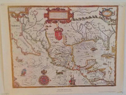
Sold2018Eastman 1853 Map of New MexicoThe South Western Part of New Mexico . Compiled from the latest explorations and drawn by Capt. S. Eastman. 9 1/2"h. x 12 1/2"W.See Sold Price
Sold2021TWO ITALIAN 1893 COLUMBIAN EXPO MEDALS.Bronze. Christopher Columbus with map of New World on front and two goddesses overlooking fair building on reverse. One in good condition with minor corrosion, the other has been cleaned with edge nicSee Sold Price
2022Blaeu, Johannes (Netherlands, 1596-1673) "The New World Map" Double Hemisphere World Map C. 1664Nova et Accuratissima Totius Terrarum Orbis Tabula Translated "The New World Map", Hand Colored w/ Elaborately Decorated Spandrels.   Sight View 16" x 21-1/2", Overall View 21" x 25-1/2"See Sold Price
Sold2024NICOLAES VISSCHER (NETHERLANDS, 1618-1709) MAP OF THE NEW WORLD"Novi Belgii Novaeque Angliae nec non Partis Virginie Tabula multis in locis emendata", 1656. Handcolored copperplate engraving on two joined sheets of wove paper as issued. Features cartouche panoramSee Sold Price
Sold2017Gabriel Tatton: Map of The New World, 1600The New World Map. 1600. Drawn by Gabriel Tatton. Engraved by Benjamin Wright. 24 x 18 inches. Please note that this lot has a confidential reserve. When you leave a bid in advance of the auction, subSee Sold Price
Sold20231600s Map of the New World drawn by Gabriel Tatton & engraved by Benjamin WrightMeasurements:With frame- 20" x 25.75"Without frame- 17.75" x 22.75"Weight- 5 lb. A portion of the proceeds from Lots 1-40 are going to the Gibbes Museum of Art in memory of Katherine M. Huger**ShippinSee Sold Price
2017Juan de la Cosa "Map of the New World 1500"Item: Juan de la Cosa "Map of the New World 1500" Description: Vintage reproduction map drawn by Juan De La Cosa By American Heritage, the magazine of history Dimensions: 24” x 18” Please note thaSee Sold Price
Sold2017Gabriel Tatton: The New World Map, 1600The New World Map 1600” drawn by Gabriel Tatton - reproduction by American Heritage, the magazine of history. Measurement approximate: 24” x 18”. Condition: Very Good Please note that this lSee Sold Price
Sold2017New Worlds, Maps from the Age of Discovery, 1st EdTitle: New Worlds. Maps from the Age of Discovery. London. Quercus. 2006 Author(s): Baynton-Williams, Ashley and Miles First edition. Condition: Fine copy in fine dust jacket (in mylar) Folio. Hard coSee Sold Price
Sold2017C1928 Flying Ambassador PosterC 1928 Flying Ambassador Poster Aviation Map Lindbergh, New Peerless World Atlas Please note that this lot has a confidential reserve. When you leave a bid in advance of the auction, submit your maximSee Sold Price
Sold2022Western Hemisphere. RARE Swedish issue by A. Akerman 1768-1774Title: Western Hemisphere. RARE Swedish issue by A. Akerman 1768-1774 Date/Period: 1768-1774 Materials: Copperplate engraved Size: 7 1/2 x 6” A very hard to obtain map of the new world. 1768-1774. BSee Sold Price
Sold2018Early 19th century School Girl Embroidery of OldEarly 19th century School Girl Embroidery of Old World-New world maps surrounded by floral garland decoration. Loss to silk and embroidery. Framed. Overall size: 21" x 29".See Sold Price
Sold20241777 William Robertson "The History Of America" First Edition, 2 VolumesDESCRIPTION: 1777 first edition of "The History of America" by William Robertson in two volumes, each featuring contemporary maps of the new world and fold-out illustrations of various paraphernalia aSee Sold Price
Sold2023Book Collection, Early Maps Of The Americas (10pc)(1) "America: Early Maps of the New World" Edited by Hans Wolff (Munich: Prestel. 1992), Folio, hardcover with dj, 192pp; (1) "The Mapping of New Spain: Indigenous Cartography and the Maps of the RelaSee Sold Price
Sold2015American Heritage Early Maps of America Reproductions(6) maps include the New World 1500 & 1600, New France 1745, the Known Globe 1667, and more, also includes a collection of noteble early maps of America Booklet See Sold Price
Sold2021Antique Map Lithographs New York City, World MapPair Antique Hand Colored Map Lithographs of New York City, and a World Map. Unframed 18 inches x 23 inchesSee Sold Price
2 days LeftJasper52MELANESIA.New Caledonia.Ponérihouen-Bourail.WW2 ROYAL NAVY INTELLIGENCE MAP 1944$10
Featured2 days LeftJasper52MELANESIA. New Caledonia. Pam-Ouaco. WW2 ROYAL NAVY INTELLIGENCE MAP 1944$10
Jun 26Templum Fine Art AuctionsHistory of Colonial Mexico - Viceroyalty of New Spain - Large and Very Rare Exceptional Map of New€1,000
4 days LeftTrillium Antique Prints & Rare BooksPrevost - Map of Australia (New Holland) with part of New Zealand$100
Jul 06Case Antiques, Inc. Auctions & AppraisalsColton's Atlas of the World, 1856, in Two Volumes; plus Africa / Mahdist War Map$500
BonhamsMITCHELL (SAMUEL AUGUSTUS) A New Universal Atlas Containing Maps of the Various Empires, Kingdom...£1,300
4 days LeftTrillium Antique Prints & Rare BooksPrevost - Volume 16 with 31 Maps & Engravings (Including Map or Australia)$210(2 bids)
4 days LeftTrillium Antique Prints & Rare BooksHarris - Map of the World (With Australia and part of New Zealand)$120(4 bids)
18 hrs LeftJasper521872 Asher and Adams Map of Maine and Parts of Quebec, Vermont and New Hampshire -- Asher & Adams$30(1 bid)
Jun 27Forum AuctionsWorld War II.- Burma & Far East.- Wingate (Brigadier O.C.) Report on Operations of 77th Indian£300


![Mapa Historico Pintoresco... Cuba... [ca. 1853].: [New World/Caribbean] MAPA HISTORICO PINTORESCO MODERNO DE LA ISLA DE CUBA. [Bernardo May, ca. 1853]. Folding map with roads, rails, and towns. Table of longitude, latitude, and distance between citie](https://p1.liveauctioneers.com/179/82189/42599756_1_x.jpg?height=310&quality=70&version=1447864785)