Sold2018Cartographer's Original Manuscript MapCartographer's Original Manuscript Map Lake Pochartrain. (Found in a bound volume of Epsy's Weather Maps ca. 1840.)x Measures 10 7/8" x 8.5". Left corner torn away. Unframed, loose and not glued or moSee Sold Price
Sold2018Korea C1945 Rare Manuscript Map. Geographical JournalVintage Manuscript Map, Rare Printers Proof (Unique) Later Published in "The Geographical Journal" by the RGS. With margin pencil annotations by the Cartographer. On very thick paper. Paper Size: 16.5See Sold Price
Sold2018Canary Islands & Morocco C1945 Rare Manuscript Map. RGSManuscript Map, Rare Printers Proof (Unique) Later Published in "The Geographical Journal" by the RGS. With margin pencil annotations by the Cartographer. On very thick paper. Paper Size: 19 x 15 inchSee Sold Price
Sold2022Description Of The Coasts of Guinea 1732 MapsBarbot. "A collection of Voyages and travels some now first printed from original manuscripts, others now first published in English in six volumes, with a general preface giving an account of thSee Sold Price
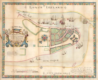
Sold20211664 / 1859 "The Duke's Plan" A Description ofBy: original cartographer unknown / Reissue by: David Thomas Valentine / Engraved by: George HaywardDate: original manuscript 1664 / Reissue 1859 (Published) New YorkDimensions: 21.75 x 27.25 inches (See Sold Price
Sold2019Thusciae Map [Italy Map]Restrike of (exact date unknown) of 'Thusciae De Scriptio Auctore Hieronymo Bellarmato;' map of Italy from original map by Abraham Ortelius (Flemish 1527-1598) Cartographer. Colorful map in VG/EX condSee Sold Price
Sold2018Saudi Arabia & Yemen C1945 Rare Proof Map. RGSManuscript Map, Rare Printers Proof (Unique) Later Published in "The Geographical Journal" by the RGS. With margin pencil annotations by the Cartographer. On very thick paper. Paper Size: 17 x 11.5 inSee Sold Price
Sold2021Mexico, Guatimala and West Indies.Title: Mexico, Guatimala and West Indies. Cartographer: BOYNTON, G. W. Publisher: S.G. GOODRICH Height: 3.25 Width: 6 Miniature school geography map. Original coloring. Reserve: $75.00 Shipping:See Sold Price
Sold2023Original Theoria Lunae Colored Map from Harmonia Macrocosmica by Andreas Cellarius (1596-1665)An original hand colored map by Dutch-German cartographer Andreas Cellarius (1596-1665), titled Theoria Lunae, Eius Motum per Eccentricum et Epicyclum Demonstrans. Piece comes from the star atlas HarmSee Sold Price
Sold2021De Fer Map of Italy, 1705[Europe, Italy] DE FER, Nicolas (1646-1720). Routes des Postes D'Italie... Engraved map with full original color and minor manuscript annotations. Paris, c. 1705. 19" x 27" sheet. This unusual, largeSee Sold Price
Sold2022Ortelius map Palestinae circa 1574 original coloringOrtelius, Abraham (1527–1598, Belgium), Cartographer, geographer and cosmographer, recognized as the creator of the first modern atlas in the 16th century: Theatrum Orbis Terrarum. Palestinae SSee Sold Price
Sold2018Persian Gulph, from the Original by D'anville. EngravedTitle/Content of Map: Persian Gulph, from the Original by D'anville. Engraved for I. Harrison... Cartographer: D'ANVILLE/HARRISON Height (inches): 11.3 Width (inches): 16.8Year: 1788 Basically a sea cSee Sold Price
Sold2023Antique 17th C Map of Canary Islands Pierre DuvalAntique 17th C Map of Canary Islands Pierre Duval. Original proof engraved in 1653 by cartographer Pierre Duval (French, 1618 - 1683). Colored boundaries of the time. Engraving margins measure 13.5 inSee Sold Price
Sold2017I.H. Coccejo / Weigel: Map of Jerusalem, 1720Map: Jerusalem, "Ierusalem aus den Schrifften Iosephi" Cartographer: I.H. Coccejo. / Weigel Place & Date: Nuremberg / 1720 Size: 16 5/8" x 13" Condition: original color; overall age toning and minor sSee Sold Price
2023Gentleman's Magazine Map, A Chart of Delaware Bay and RiverTitle: A Chart of Delaware Bay and River, from the original by Mr. Fisher of Philadelphia 1776. Engraved map by cartographer Joshua Fisher. Featured in the July 1779 edition of Gentleman s Magazine. FSee Sold Price
Sold2023Gentleman's Magazine Map, A Chart of Delaware Bay and RiverTitle: A Chart of Delaware Bay and River, from the original by Mr. Fisher of Philadelphia 1776. Engraved map by cartographer Joshua Fisher. Featured in the July 1779 edition of Gentleman's MagazinSee Sold Price
Sold2024Antique TC Lotter Magni Turcarum Dominatoris Map19.5 X 22.5 Antique map by famous German cartographer Tobias Conrad Lotter of the Turkish empire, Magni Turcus Dominatoris Imperium. Shows regions of Europe, Asia, and Africa. Original publication donSee Sold Price
Sold2018Stieler: West Indies & Central America Colonial PowersReserve Reduced! Map Title: West-Indien und Centro-America. Cartographer: Adolf Stieler / Justus Perthes Geographical Institute Place / Date: Gotha / 1841 Size: 9 3/8" x 7 1/4" Condition: original outSee Sold Price
Sold2021Manuscript Map of the Holy Land, early 18th Century[Manuscript map of the Holy Land] Pencil, ink, and watercolor on faux vellum with horizontal and vertical folding creases (8 segments) and no mounting guard; pencil grid visible in upper left and righSee Sold Price
Sold2020Original Map, Nantucket Drawn by Rev F.C. Ewer, 1869Original Historical Map of Nantucket Surveyed and Drawn by Reverend F.C. Ewer D.D., 1869, (Ferdinand Cartwright 1826-1883) mounted on canvas, unframed. 12 ¾ in. x 20 in.See Sold Price
Sold2021Original manuscript poem by BukowskiHeading: Author: Bukowski, Charles Title: Original manuscript poem - About a Non-Typing Night Place Published: [n.p.] Publisher: Date Published: [1984] Description: Original MaSee Sold Price
Sold2022(MANUSCRIPT MAP -- CAPE TOWN.) Vue de Cap de Bonne Esperence.(MANUSCRIPT MAP -- CAPE TOWN.) Vue de Cap de Bonne Esperence. Pen and ink and watercolor wash on laid paper. 12¾x22¾ inches sheet size, ample margins; stain at right edge, backed with thin tSee Sold Price
Sold2022Sidney, Algernon Discourses concerning Government. Published from an Original Manuscript of theSidney, Algernon Discourses concerning Government. Published from an Original Manuscript of the London: to be sold by the booksellers, 1698. Folio (31 x 19.5cm), contemporary mottled calf panelled inSee Sold Price
Sold2022Red Mining District Original Map; 1891 [152840]Real, original Map of the Red Mountain Mining District, Ouray County, Colorado. Scale of 1000 ft. to 1 inch. W.A. Sherman M.E. Ouray, Colo. 1891. Printed by Rand McNally & Co. Engravers, Chicago. HasSee Sold Price
6 days LeftHolabird Western Americana CollectionsFont's Complete Diary / Founding of San Francisco 1933 [181866]$75
Jun 07Holabird Western Americana CollectionsPyramid Lake Print Pair & 1885 NM & UT Territory Map [179398]$150
Jun 07Freeman's | Hindman[LEWIS & CLARK EXPEDITION]. The Journal of the Lewis & Clark Expedition. Gary E. Moulton, editor.$300(1 bid)
BonhamsILLUMINATED MANUSCRIPT - NINETEENTH CENTURY The Ballad of Chevy Chase, ILLUMINATED MANUSCRIPT, '...£500
BonhamsHARLEQUINADE - MANUSCRIPT FLAP-BOOK A seventeenth century manuscript pictorial flap-book 'Painte...£1,800
BonhamsMITCHELL (SAMUEL AUGUSTUS) A New Universal Atlas Containing Maps of the Various Empires, Kingdom...£1,300
BonhamsBOWYER (ROBERT) An Impartial Historical Narrative of those Momentous Events which have Taken Pla...£10
BonhamsROWLANDSON (THOMAS) [ENGELBACH (LEWIS)] Naples and the Campagna Felice, 1815--Poetical Sketches ...£300


![Thusciae Map [Italy Map]: Restrike of (exact date unknown) of 'Thusciae De Scriptio Auctore Hieronymo Bellarmato;' map of Italy from original map by Abraham Ortelius (Flemish 1527-1598) Cartographer. Colorful map in VG/EX cond](https://p1.liveauctioneers.com/5755/154409/77936957_1_x.jpg?height=310&quality=70&version=1573094011)


![De Fer Map of Italy, 1705: [Europe, Italy] DE FER, Nicolas (1646-1720). Routes des Postes D'Italie... Engraved map with full original color and minor manuscript annotations. Paris, c. 1705. 19" x 27" sheet. This unusual, large](https://p1.liveauctioneers.com/1968/216191/110783529_1_x.jpg?height=310&quality=70&version=1629990486)


![Manuscript Map of the Holy Land, early 18th Century: [Manuscript map of the Holy Land] Pencil, ink, and watercolor on faux vellum with horizontal and vertical folding creases (8 segments) and no mounting guard; pencil grid visible in upper left and righ](https://p1.liveauctioneers.com/1968/225974/116712048_1_x.jpg?height=310&quality=70&version=1636655147)

![Original manuscript poem by Bukowski: Heading: Author: Bukowski, Charles Title: Original manuscript poem - About a Non-Typing Night Place Published: [n.p.] Publisher: Date Published: [1984] Description: Original Ma](https://p1.liveauctioneers.com/642/220632/113472866_1_x.jpg?height=310&quality=70&version=1633303857)


![Red Mining District Original Map; 1891 [152840]: Real, original Map of the Red Mountain Mining District, Ouray County, Colorado. Scale of 1000 ft. to 1 inch. W.A. Sherman M.E. Ouray, Colo. 1891. Printed by Rand McNally & Co. Engravers, Chicago. Has](https://p1.liveauctioneers.com/2699/258191/134290995_1_x.jpg?height=310&quality=70&version=1660351799)


![Font's Complete Diary / Founding of San Francisco 1933 [181866] (1 of 8)](https://p1.liveauctioneers.com/2699/331494/178785432_1_x.jpg?height=282&quality=70&version=1717094654)

![Pyramid Lake Print Pair & 1885 NM & UT Territory Map [179398] (1 of 2)](https://p1.liveauctioneers.com/2699/331495/178785761_1_x.jpg?height=282&quality=70&version=1717094933)


![[Mitchell, J. Leslie] Lewis Grassic Gibbon (1 of 1)](https://p1.liveauctioneers.com/94/330664/178342390_1_x.jpg?height=282&quality=70&version=1716466933)


![[LEWIS & CLARK EXPEDITION]. The Journal of the Lewis & Clark Expedition. Gary E. Moulton, editor. (1 of 1)](https://p1.liveauctioneers.com/197/329395/177650557_1_x.jpg?height=282&quality=70&version=1715364962)


![[The Thames] Tombleson (1 of 1)](https://p1.liveauctioneers.com/94/330664/178342457_1_x.jpg?height=282&quality=70&version=1716466933)


![ROWLANDSON (THOMAS) [ENGELBACH (LEWIS)] Naples and the Campagna Felice, 1815--Poetical Sketches ... (1 of 2)](https://p1.liveauctioneers.com/1043/319451/178359240_1_x.jpg?height=282&quality=70&version=1716978906)