Sold2017Smith: Antique Map of the World, 1835Map: 1835 Smith World Map -- A Chart Exhibiting the Actual and Comparative Size of each Country, Nation, or Kingdom; its Population as a Whole and to a Square Mile. Also the Different States of SocietSee Sold Price
Sold20211835 Smith World Map -- A Chart Exhibiting the ActualTitle: 1835 Smith World Map -- A Chart Exhibiting the Actual and Comparative Size of each Country, Nation, or Kingdom; its Population as a Whole and to a Square Mile. Also the Different States of SociSee Sold Price
Sold2018Thomson: Comparative Heights of the World’s MountainsThomson: Comparative Heights of the World’s Mountains The fascinating chart of the comparative heights of the world's mountains, with the Western Hemisphere's peaks on the left dwarfed by those of tSee Sold Price
Sold20201855 Johnston World Map with Comperative Chart ofTitle/Content: 1855 Johnston World Map with Comperative Chart of Rivers and Mountains -- The World in Hemispheres, with Comparative Views of the Heights of ths Principal Mountains and Lengths of the PSee Sold Price
Sold20211858 THE VOLUME OF THE WORLD BY THOMAS PRESCOTT.The Volumbe of the World: Embracing the Geography, History, and Statistics of the Nations of the Earth: Their Governments, Institutions, Finances, Populations, Industry, Productions, Arts, Sciences, ESee Sold Price
Sold2022Scarce Heights of Mountains, 1833 Anthony Finley mapStriking and very scarce visual Table of the Comparative Heights of the Principal Mountains in the World. Highly sought-after chart from the elusive 1833 edition of Anthony Finley’s New GeneralSee Sold Price
Sold2023German Military Propaganda Leaflet from World War II. Addressed to the Ukrainian PopulationGerman military propaganda leaflet from World War II. Addressed to the Ukrainian population. Flyer with the content: Peasants! The German government that liberated you ordered the handing over of landSee Sold Price
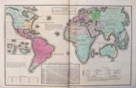
Sold20211821 Woodbridge Thematic World Map of Type ofTitle: 1821 Woodbridge Thematic World Map of Type of Inhabitation -- Chart of the Inhabited World Exhibiting the Prevailing Religion, form of Government, Degree of Civilization and Population... CartoSee Sold Price
Sold2019Chart Exhibiting the Actual and Comparative Size ofTitle/Content of Map: Chart Exhibiting the Actual and Comparative Size of Each Country, Nation, Or Kingdom: Its Population As a Whole and to a Square Mile: Also the Different States of Society, FormsSee Sold Price
Sold20231844 Chart of Comparative Mountains and RiversEngland, 19th century. A wonderful example of Adam & Charles Black's depiction various mountain elevations of the world. It also captures various rivers in immense detail. Overall good conditSee Sold Price
Sold2023Ainsworth, James 1850's LG Folio Print. River and Mountain Chart"Comparative View of the Principal Rivers and Mountains of the World" Large Folio Steel Engraving (Reverse side blank) Published 1851-55, Manchester for "The Imperial Journal of Art, Science, MechanicSee Sold Price
Sold2022Scarce format of Comparative Mts. & Rivers, 1864Johnson’s reimagined and re-engraved set of five comparative charts of the Mountains & Rivers of the World, presented in the very uncommon vertical format and organized by continent. Quite a deSee Sold Price
Sold2023Scarce format of Comparative Mts. & Rivers, Johnson 1865Johnson’s reimagined and re-engraved set of five comparative charts of the Mountains & Rivers of the World, presented in the very uncommon vertical format and organized by continent. Quite a depSee Sold Price
Sold2023Scarce format of Comparative Mts. & Rivers, Johnson 1864Johnson’s reimagined and re-engraved set of five comparative charts of the Mountains & Rivers of the World, presented in the very uncommon vertical format and organized by continent. Quite a depSee Sold Price
Sold2018World chart with discoveries of James Cook 1787Heading: Author: Faden, William Title: A New General Chart of the World, Exhibiting the Whole of the Discoveries made by the late Captain James Cook, F.R.S. with the Tracks of the Ships under his ComSee Sold Price
Sold2024JONAS SALK, WORLD POPULATION BOOK, SIGNEDWorld Population and Human Values by Dr. Jonas Salk. Published 1981 by Harper and Row. Inscribed and signed by Jonas Salk on the half-title page. Jonas Salk (1914-1995) was an American virologist andSee Sold Price
Sold2020Maine. With population chart. 1850 by Thomas.Title: Maine. With population chart. 1850 by Thomas. Date/Period: c1850 Materials: Hand colored, steel engraved. Size: 16 1/2 x 13 1/2 inches. c1850 by Thomas, Cowperthwait & Co. From 'A New UniversalSee Sold Price
Sold2020Arkansas. With detailed population chart of towns andTitle: Arkansas. With detailed population chart of towns and counties. 1850 by Thomas Date/Period: c1850. Materials: Hand colored steel engraved Size: 16 1/2 x 13 1/2 inches. c1850 by Thomas, CowperthSee Sold Price
Sold2022United States Irish and German decent population chart. 1874 by Francis WalkerTitle: United States Irish and German decent population chart. 1874 by Francis Walker Date/Period: 1874 Materials: Color Lithographie printing Size: 17x21" First Statistical atlas of the US, by FraneiSee Sold Price
Sold20211899 World Population MapTitle: 1899 World Population Map Author: Freytag Medium: Ink on Paper Dimensions: 15.5"X10.5" Description: World Map dated 1899. Printed by Karl Freitag. Published in Vienna. Key upper left. CapturesSee Sold Price
Sold2017Antique Nautical Chart of West Mediterranean SeaMap: Old nautical chart of the west Mediterranean Sea Subtitle: Mediterranean Sea, Gibraltar to Alicante, Cape Spartel to Cape Ferrat from Spanish and French Government Charts to 1877. Creator: BritisSee Sold Price
Sold2020Massachusetts & Rhode Island. With insert of Boston andTitle: Massachusetts & Rhode Island. With insert of Boston and population chart. 1850 by Thomas. Date/Period: c1850 Materials: Hand colored, steel engraved. Size: 16 1/2 x 13 1/2 inches. c1850 by ThomSee Sold Price
Sold2021Group of 2 Marvel Comics The Infinity Gauntlet No. 1July 1991, Modern Age, $2.50, Thsnos eliminates half the world population using the Infinity Gauntlet to impress the cosmic entity, Death. Bagged and boardedSee Sold Price
Sold2023Gross, Alexander 1920 Lot of 5 Large Maps. World & OceansIncl World Hemispheres, North Atlantic, South Atlantic, World Rainfall, Temperature and Winds, and World Population and Occupations. Large Lithograph Maps Published 1920, London for "The Daily TelegraSee Sold Price
7 days LeftMusicGoldmine.comGotye ft. Kimbra "Somebody That I Used To Know" RIAA 6X Multi-Platinum Digital Single Award - New$250
7 days LeftMusicGoldmine.comChristina Perri "Jar Of Hearts" Atlantic Records Ireland Single Award$150
7 days LeftMusicGoldmine.comRod Stewart Unplugged... and Seated RIAA 3x Multi-Platinum Album Award$300
May 26Ararity AuctionsThomson's 1817 Hand Colored Map Comparative Heights of the World's Great Mountains$50
Jun 07Freeman's | HindmanBERGERAC, Cyrano de. Selenarchia. Or, the Government of the World in the Moon: A Comical History.$2,250