Sold20211899 World Population MapTitle: 1899 World Population Map Author: Freytag Medium: Ink on Paper Dimensions: 15.5"X10.5" Description: World Map dated 1899. Printed by Karl Freitag. Published in Vienna. Key upper left. CapturesSee Sold Price
Sold2019Bartholomew, John 1922 Lot of 5 Maps of The WorldIncl Mapping of the World, World-Bathy-Orographical, World Climate, World-Vegetation & Ocean Currents, World-Population. Large Lithograph Maps Published 1922 by The Times, London for "The Times SurveySee Sold Price
Sold2016Map of California, 1899By Rand, McNally & Co., from Indexed Atlas Of The World. Chicago: 1899. Map features vignettes of Los Angeles, San Bernadino, Orange & San Diego Counties and seperate vignette of San Francisco area. DSee Sold Price
Sold2023Gross, Alexander 1920 Lot of 5 Large Maps. World & OceansIncl World Hemispheres, North Atlantic, South Atlantic, World Rainfall, Temperature and Winds, and World Population and Occupations. Large Lithograph Maps Published 1920, London for "The Daily TelegraSee Sold Price
Sold2020Winston handy atlas of the world with Gazetteer of theTitle/Content of Map: Winston handy atlas of the world with Gazetteer of the world comprising countries and their political subdivisions; the cities and towns of the world; with populations accordingSee Sold Price
Sold2020Bartholomew, John 1922 Lot of 5 Maps of the WorldIncl Mapping of the World, Bathy-Orographical, Population/Races/Languages/Religions, Commercial Development/Occupations/Means of Traffic, and Political. Large Lithograph Maps Published 1922 by The TimSee Sold Price
Sold2020Framed Hand Colored Map of The World 19th CenturyFramed Hand Colored Map of The World 19th Century. Original Map of World Hemispheres with supposed population and religious division. Certificate of Authenticity on back.Condition: Very Good, slight wSee Sold Price
Sold2021Lot of 4 Maps: ATLAS ANTIQUUS:12 MAPS OF ANCIENT WORLDLot of 4 Antique Maps from ATLAS ANTIQUUS: TWELVE MAPS OF THE ANCIENT WORLD by Heinrich Kiepert (1818-1899) | Published: Berlin, Dietrich Reimer, 1884-1885 | Each is a Double-Page Colored Map originatSee Sold Price
Sold2016United States Map, Density of Population, 1895Original engraving from Atlas of the World by Rand McNally, 1895. Map includes counties, geographical landmarks, streets and population data. Dimensions: 21 1/4" x 14" No Reserve Buyer pays shipping -See Sold Price
Sold2016United States Map, Increase / Decrease of Population,Original engraving from Atlas of the World by Rand McNally, 1895. Map includes counties, geographical landmarks, streets and population data. Dimensions: 21 1/4" x 14" No Reserve Buyer pays shipping -See Sold Price
Sold2017Map of the United States showing Density of PopulationRand, McNally & Co. 1898 New Standard Atlas of the World. Also contains census information on population 1870, 1880, and 1890 Size: 21 x 15 inches No Reserve: This lot starts at $1 and has no reserveSee Sold Price
Sold2021Bartholomew, John 1889 Lot of 4 Maps. World etcIncl Diseases/Population, Races/Religions, Isochronic Distance/Postal Map, and British Isles - Rain/Crops/Orographical/Pasture Land. Lithograph Maps Published 1889, Cambridge for "Atlas of CommercialSee Sold Price
Sold2023A Decorative Pictorial Map of The New York Worlds Fair by William L. Longyear (American, 1899-1980)A Decorative Pictorial Map of The New York Worlds Fair by William L. Longyear (American, 1899-1980). Framed. Designed and copyrighted by William Longyear. Lithographed in U.S.A by Polygraphic CompanySee Sold Price
Sold20211970 Humbead's Revised Map Of The World PosterThis rare 1970 edition of Humbead's Map of the World was not widely distributed. It includes approximately 250 new names not in the 1969 population list including Barbi Benton, Bernie Wrightson, BilboSee Sold Price
Sold2016Map of Maine, 1895Original engraving from Atlas of the World by Rand McNally, 1895. Map includes counties, geographical landmarks, streets and population data. Dimensions: 21 1/4" x 27 1/2" No ReserveSee Sold Price
Sold2016Map of Massachusetts (inset of Boston), Martha'sOriginal engraving from Atlas of the World by Rand McNally, 1895. Map includes counties, geographical landmarks, streets and population data. Dimensions: 21 1/4" x 27 1/2" No Reserve This item ships fSee Sold Price
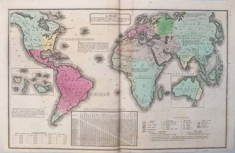
Sold2017Smith: Antique Map of the World, 1835Map: 1835 Smith World Map -- A Chart Exhibiting the Actual and Comparative Size of each Country, Nation, or Kingdom; its Population as a Whole and to a Square Mile. Also the Different States of SocietSee Sold Price
Sold20211835 Smith World Map -- A Chart Exhibiting the ActualTitle: 1835 Smith World Map -- A Chart Exhibiting the Actual and Comparative Size of each Country, Nation, or Kingdom; its Population as a Whole and to a Square Mile. Also the Different States of SociSee Sold Price
Sold2016Map of Washington State, 1895Original engraving from Atlas of the World by Rand McNally, 1895. Map includes counties, geographical landmarks, streets and population data. Dimensions: 21 1/4" x 27 1/2" Shipping Domestic: ShippingSee Sold Price
Sold2016Map of Nevada, 1895Original engraving from Atlas of the World by Rand McNally, 1895. Map includes counties, geographical landmarks, streets and population data. Dimensions: 21 1/4" x 14" No Reserve Buyer pays shipping.See Sold Price
Sold2016Map of Oregon, 1895Original engraving from Atlas of the World by Rand McNally, 1895. Map includes counties, geographical landmarks, streets and population data. Dimensions: 21 1/4" x 27 1/2" No Reserve Buyer pays shippiSee Sold Price
Sold2021Atq Map & Atlas Books, 1899 Spoffords & More - 1899Atq Map & Atlas Books, 1899 Spoffords & More - 1899 Maps Spofford's Cabinet Encyclopedia, 1906 Hammonds Pictorial Atlas of World w/ 1956 Hammond Double Day AtlasSee Sold Price
Sold2023Educator Shoes 9.75" World Map Wheel (1931) US AdvertisingEducator Shoes 9.75" World Map Wheel (1931) US Advertising Lists the Current Population, etc. Condition: EXC Reserve: $55.00 Shipping: Domestic: Flat-rate of $42.00 to anywhere within the contiguous USee Sold Price
Sold20211899 Map of LousianaAuthor: Matthews Title: 1899 Map of Lousiana Medium: Ink on Paper Dimensions: 13.5"X11" Map of Louisiana dated 1899. Published by the Matthews Northrup Co. in Buffalo. With extensive dated population,See Sold Price
Featured3 days LeftJasper521699 Moll World Map with Cowley's Voyages -- Nouvelle Carte du Monde Suivant l'idee de Mercator ou$240
Jun 09Worthington Galleries19th c. Hemisphere World Map, Hohen und Tiefen der Erde in Lambert’s Zenithal-Projection von$10
Jun 09Worthington Galleries18th c. Map OBSERVATIONS SUR LES POINTS CARDINAUX. LIGNES, ET CIRCLES DE LA SPHÈ$10
3 days LeftJasper521771 ASTRONOMY by Joseph M. de La Lande 2 VOLUMES ILLUSTRATED antique in FRENCH$480
6 days LeftNorthgate Gallery, Inc.Vintage Baker Furniture George II Style Wing Back Arm Chairs, Pair$200
6 days LeftTrillium Antique Prints & Rare BooksSanson - Map of Canada or New France with the Great Lakes$75
Jun 09Worthington GalleriesAntique Hand-colored Hemisphere Map Mappemonde Revue par E. Cortambert 1864$25
6 days LeftTrillium Antique Prints & Rare BooksSanson - Map of Florida (encompassing most of Southeast North America)$75(1 bid)
6 days LeftTrillium Antique Prints & Rare BooksSanson - Map of the British Isles (Ireland, Scotland, England)$75
Jun 07AUTOMOBILIA LADENBURG AUCTION1943, original English pamphlet for the German population (World War II) with the title "Kraft durch€120