Sold20161972 A Map of the British Empire in America PoppleDESCRIPTION: 1972 Folio of Henry Popple's 1733 Map of the British Empire in North America. Each map section with support binding. Published by Harry Margary Lympe Castle Kent with the assistance of ThSee Sold Price
Sold2022Popple, Henry,(Britain, 16?? - 1743) A Map of The British Empire in America with French, Spanish and(d. 1743) Printed In Amsterdam For L Covens And C. Mortier c.1755, Sight View 19" x 18-1/2", Overall 21" x 26" "Carte Particuliere de l'Amerique Septentrionale."See Sold Price
Sold2018Key map of Popple's British North AmericaHeading: Author: Popple, Henry Title: A Map of the British Empire In America with the French, Spanish and the Dutch Settlements adjacent thereto by Henry Popple Place Published: Amsterdam Publisher:ISee Sold Price
Sold2023Map of the British Empire in AmericaPublication Date: 1733 Title: Map of the British Empire in America Cartographer: Henry Popple Publisher: Covens & Mortier Height: 23 Width: 20.5 with the French, Spanish and the Dutch Settlements adjaSee Sold Price
Sold2023[OLDMIXON, John]. The British Empire in America. FIRST EDITION.[OLDMIXON, John (1673-1742)]. The British Empire in America, Containing the History of the Discovery, Settlement, Progress and Present State of all the British Colonies on the Continent and Islands ofSee Sold Price
Sold20231762 Accurate Map British Empire North AmericaAn Accurate Map of the British Empire in North America as Settled by the Preliminarues in 1762, by Gibson for Gentleman's Magazine, 1762. Folding map with inset of the entance to the Mississippi. FineSee Sold Price
Sold20191770 Wynne Britain in America French/Indian WAR1770 Wynne Britain in America French/Indian WAR Colonial Voyages Plymouth 2v RARE John Wynne’s ‘History of the British Empire in America’ is a late 18th-century account of the foundation of theSee Sold Price
Sold20211762 Map of the British Empire in North AmericaHistoric Maps 1762 Map, "An Accurate Map of the British Empire in Nth America as settled by the Preliminaries in 1762" 1762 French and Indian War Period Map titled, "An Accurate Map of the British EmpSee Sold Price
Sold2023Samuel Dunn, Map of the British Empire in North America, EngravingTitle: Map of the British Empire in North America; By Samuel Dunn, Mathematician. Artist: Samuel Dunn Publisher: London: Printed for Robt. Sayer, No. 53 in Fleet Street. Reference: Stevens & Tree, "See Sold Price
Sold2020KITCHIN, THOMAS. A New Map of the British Empire inKITCHIN, THOMAS. A New Map of the British Empire in Nth. America. Hand-colored engraved folding map of colonial North America from George Millar's New and Universal System of Geography. 13½x15See Sold Price
Sold2022Lot of 2 American Revolution Strategy GamesThe American Revolution Strategy Game Lot of 2 including The British Empire in North America - End of Empire 1744-1782 by Compass Games and Liberty The American Revolution 1775-1783 by Columbia Games.See Sold Price
Sold2022Times Atlas 1895 Mixed Lot of 9 MapsIncl Religions, Wind, Japan, Palestine, Antilles, Central America/West Indies, Atlantic, South America and British Empire. Lithograph Map Published 1895, London for "The Times Atlas" Paper Size: Up toSee Sold Price
Sold2021HERMAN MOLL English Empire EngravingHERMAN MOLL English Empire Engraving, inscription reads ‘The English Empire in America, Newfoundland Canada Hudson’s Bat Herman Moll Fecit’, subject a map of the British empire, measures 14 1/8See Sold Price
Sold20221721 Senex Map of British Caribbean Islands -- A New Map of the English Empire in the Ocean ofTitle: 1721 Senex Map of British Caribbean Islands -- A New Map of the English Empire in the Ocean of America or West Indies Cartographer: J Senex Year/Place: 1721, London Dimensions: 20.1 X 23.8 in.See Sold Price
Sold2018Senex: Antique Map Jamaica & British West Indies, 1721Title/Content of Map: A new map of the English Empire in the Ocean of America or West Indies Cartographer: J. Senex Place & Date: London / 1721 Size: 23 3/4" x 20" Condition: full wash color; repairedSee Sold Price
Sold2023Pinkerton, John 1811 Antique Map. British Possessions in America. Canada (Faults)Copper Engraved Map Published 1811, London for "Modern Geography. A Description of the Empires, Kingdoms, States and Colonies..." by John Pinkerton. Paper Size: 11 x 8.5 inch (28 x 21cm) Folds as bounSee Sold Price
Sold2021Clarke, J. W. 1817 Print. View of Quebec, Canada"View of Quebec, The Capital of British America" Copper Plate Published 1814-27, London for "A New Geographical Dictionary; Containing a Description of all the Empires, Kingdoms, States and Provinces.See Sold Price
Sold2022(BRITISH EMPIRE.) George Philip & Son, Ltd.; and The London Geographical Institute. Navy League Map(BRITISH EMPIRE.) George Philip & Son, Ltd.; and The London Geographical Institute. Navy League Map of the British Empire. Oversize chromolithograph map of the world delineating early 20th-century BriSee Sold Price
Sold2022William Winstanley(British/America, 1775-1806) George Washington, after Gilbert Stuart (American, 1755-1828), unsigned, oil on canvas, 28-3/4 x 24 in.; original carved gilt wood and composition frame, 35 x 30 in.See Sold Price
Sold2022[NAPOLEONIC BRITISH ARMY UNIFORMS]. SMITH, Charles Hamilton. 1814[NAPOLEONIC BRITISH ARMY UNIFORMS]. SMITH, Charles Hamilton. Costume of the Army of the British Empire, according to the latest regulations, 1814. Designed by an officer of the staff. London: W. BulmeSee Sold Price
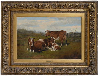
Sold2023Arthur Fitzwilliam Tait(British/America, 1819-1905) Cows, 1892, signed and dated lower right "A.F. Tait, NA/NY 92", oil on canvas, 18 x 27-1/4 in.; period carved gilt wood and composition frame, 31 x 40 in. Literature: CadbSee Sold Price
Sold2022The Collected Works of Churchill, Centenary EditionThe Centenary Limited Edition of The Collected Works of Sir Winston Churchill (London, 1973-76; number 2091 of an edition limited to 2,000 copies for the British Empire and 1,000 for the United StatesSee Sold Price
Sold2015Incredible Roman Bronze Shield BossRoman Empire, British Military Legion, ca, 2nd to 4th century CE. Large and extremely rare bronze shield boss. Used by Roman legion foot soldiers to deflect blows to their shield. Large round plate doSee Sold Price
Sold2022Evans, Lewis A General Map of the Middle British Colonies in AmericaEvans, Lewis A General Map of the Middle British Colonies in America viz. Virginia, Maryland, Delaware, Pensilvania, New-Jersey, New York, Connecticut and Rhode Island: of Aquanishuonigy the Country oSee Sold Price
May 17Albion AuctionsClarke & Russell 1814 Hand Col Map. Canada - British Dominions in North America$5(1 bid)
4 days LeftHermann Historica GmbHA parcel from the hatter Herbert Johnson to Lieutenant Colonel Wilson, circa 1937€300
1818 AuctioneersJERSEY 9 x RAF (DM) Flown Gallantry Medal Awards Autographed Covers, Limited Editions, signed by£42
6 days LeftSchilb Antiquarian Rare Books1865 State of VIRGINIA Jones Colonial America INDIANS Negroes Slaves #28/50$72(4 bids)
3 days LeftHunt and Peck Estate Services, Inc.1794 Laurie & Whittle after Thomas Jefferys Map Of The United States Of America$360(2 bids)
2 days LeftEldred'sMARIAN WEISBERG (America, Contemporary), Possum on a rock., Ceramic, copper and composite, height$150
6 days LeftSchilb Antiquarian Rare Books1861 William Wilberforce Enormity of SLAVE TRADE Abolition Bill America RARE$40(3 bids)
May 15University ArchivesDeclaration of Independence, Very Early British Publ. in Gentleman's Magazine & Rare Map$1,000
3 days LeftAuctions 4 America IncOld Master 17th Century oil on Canvas, Original Gilded Frame$1,200(3 bids)
3 days LeftAuctions 4 America IncPre-Columbian Colima Vessel with Figure, Ex-Sotheby's Piece$275(4 bids)


![[OLDMIXON, John]. The British Empire in America. FIRST EDITION.: [OLDMIXON, John (1673-1742)]. The British Empire in America, Containing the History of the Discovery, Settlement, Progress and Present State of all the British Colonies on the Continent and Islands of](https://p1.liveauctioneers.com/197/305583/163286615_1_x.jpg?height=310&quality=70&version=1697143109)


![[NAPOLEONIC BRITISH ARMY UNIFORMS]. SMITH, Charles Hamilton. 1814: [NAPOLEONIC BRITISH ARMY UNIFORMS]. SMITH, Charles Hamilton. Costume of the Army of the British Empire, according to the latest regulations, 1814. Designed by an officer of the staff. London: W. Bulme](https://p1.liveauctioneers.com/6713/243800/126402528_1_x.jpg?height=310&quality=70&version=1649373694)