Sold2020Continent maps from Heylyn's Cosmography 1703Heading: Author: Heylyn, Peter Title: Set of four continent maps from Heylyn's Cosmography, including America showing California as an island Place Published: [London] Publisher: Date Published:See Sold Price
Sold2022c. 1703 Map AMERICA by Peter Heylyn Calif. IslandHistoric Maps Rare Circa 1703 Hand-Colored Engraved Map titled: "AMERICA" with California as an Island by Peter Heylyn c. 1703 Hand-Colored Engraved Map titled "AMERICA" by Peter Heylyn, showing CalifSee Sold Price
Sold2017Robert Morden - English Plantations in AmericaRobert Morden (d. 1703) and William Berry (fl. 1669-1708) makers A New Map of the English Plantations in America both Continent and Ilands Shewing their true Situation and distance from England or oneSee Sold Price
Sold2023[MAPS]. HOMANN, Johann Baptist (1663-1724). Four engraved continent maps with hand-coloring, each[MAPS]. HOMANN, Johann Baptist (1663-1724). Four engraved continent maps with hand-coloring, each matted and framed, comprising: Totius Americae… Nuremberg, [ca 1720]. Overall sheet 508 x 590 mmSee Sold Price
Sold2017Scherer: 3 Catholic-themed Antique Maps, 1703Map: America Borealis Cartographer: H. Scherer Place & Date: Munich / 1703 Size: 7" x 9 1/4" Condition: b&w; light overall age toning Three maps on a single sheet from Scherer's Geographia ArtificialiSee Sold Price
Sold2021Bartholomew, John 1889 Lot of 5 Continents MapsCommercial Continent Maps of Asia, Africa, Europe, North & South America. Lithograph Maps Published 1889, Cambridge for "Atlas of Commercial Geography" by John George Bartholomew. Paper Size: 12 x 10See Sold Price
Sold2021Hall, Sidney C1850 Set of 5 Continent MapsEurope, Aisa, Africa, North America, and South America. Steel Engraved Maps Published C1850, London for "A Grammar of General Geography..." by the Rev. J. Goldsmith & Edward Hughes. Folds as issed. MaSee Sold Price
Sold2019Graf: Large South America Continent Map, 1861Cartographer: Geographisches Institut. / Graf Place/Date: Weimar / 1857/1861 Size: 17 3/4" x 22" Condition: wash color; light overall age toning and a minor stain on the right edge of the wide margin,See Sold Price
Sold2022Times Atlas 1895 Lot of 4 Continents MapsIncl Europe, Asia, North America and South America. Lithograph Map Published 1895, London for "The Times Atlas" Centre fold as published. Paper Size: 21.5 x 16 inch (54 x 41cm) Good ConditionSee Sold Price
Sold20191703 Delisle Map of Southern Portions of South AmericaTitle/Content of Map: 1703 Delisle Map of Southern Portions of South America -- Carte du Paraguay du Chili du Detroit de Magellan &c. Dressee sur les Descriptions des PP. Alfonse d'Ovalle, et NicolasSee Sold Price
Sold2023Map of Kan. Neb. Col. Dak. Et al, Mitchell 1872Great mid-continent map; shows Montana with just 2 counties, Wyoming with only 5 counties and early images of Colorado and Dakota. Shows the Little Big Horn area just four years before General CusterSee Sold Price
2017Lumsden: Map of Asia, 1785Map: Asia Publication Date: 1785 Maker: LUMSDEN, sculp. Size: Quarto – 6.80 H x 8.60 W Inches Continent map from Salmon's Geography. Modern coloring. Reverse repairs. Please note that this lot has aSee Sold Price
Sold2018AfricaTitle: Africa Publication Date: 1763 Cartographer: JEFFERYS, T. Publisher: S. AND E. BALLARD, etc. Size: 7X9.5 Continent map from Salmon's The Modern Gazetteer. 5th edition. Few stains. Please note thSee Sold Price
Sold2018North AmericaTitle/Content of Map: North America Date Printed: 1820 Cartographer: Size: 10.6X8 Polar projected continent map showing the United States and the much larger Louisiana Territory. From the Seventh editSee Sold Price
Sold20201588 Leaf Munster Cosmography MapA leaf from an edition of Sebastian Munster's Cosmographia, circa 1588. Large map on one side and a mining scene on the verso. Very Good, some dampstain away from images. Measures 8 x 12.5" Reserve: $See Sold Price
Sold2020Hall, Sidney 1852 Lot of 4 Maps - ContinentsIncl Asia, Africa, Europe and South America. Steel Engraved Map Published 1852, London for "A Grammar of General Geography" by the Rev. Goldsmith. Engraved by Sidney Hall. Folds as issued. Paper Size:See Sold Price
Sold2021Brockhaus (Pub) 1890's Lot of 6 Maps of AfricaIncl German East Africa, Egypt, Equatorial Africa and Political, Ethnographic and Physical Maps of the African Continent. Lithograph Maps Published 1892-98 by F. A. Brockhaus, Leipzig for "Brockhaus'See Sold Price
Sold2024Robert Morden (British, 1650-1703) Map AssortmentRobert Morden (British, 1650-1703) Map Assortment (5) items including (4) by Morden pulled from Gibson's edition of 'Camden's Britannia', first Morden edition, published by Abel Swale and John ChurchiSee Sold Price
Sold2020Framed Antique Map Orbis Vetus, Robert De VaugondyItem/Description: Old print. Map of the world by Robert de Vaugondy from 1752. Orbis vetus in utraque continente : In both the old continent / world map / Vaugondy 1752. Material: Print framed under gSee Sold Price
Sold2023Britanna Romana Antique Hand Colored Map by Robert Morden, 1722Britanna Romana antique hand colored map. Originally by Robert Morden (1650 – 1703). Map depicting British Isles from Camden's Britannia, there is a fold in the middle where it was folded intoSee Sold Price
Sold2017Mallet: Antique Map of Antarctica, 1683Title/Content of Map: 'Continent Meridional Austral ou Antarctique' ANTARCTIC: Australia/New Holland incomplete. Unknown lands. Date Printed: 1683 Image Size: Approx Overall page size 13 x 21cm approxSee Sold Price
Sold2017Framed Map of North AmericaFramed Map of the North American Continent. Marked “Map Produced by Allan Cartography of Medford, Oregon, with the assistance of Dr. A. Jon Kimerling, Department of Geosciences, Oregon State UniversSee Sold Price
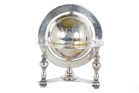
Sold2023Bulgari Sterling Silver & Vermeil Table Globe 805gA Bulgari Italian sterling silver table globe sculpture. Classical style design with spinning world map globe set within a round tri legged ring stand. Map continents finished in gold vermeil, and surSee Sold Price
Sold2021Glass World Globe PaperweightClear glass globe with textured and shaded world map continents. Measures 3 x 3.25 in. Desktop items, Paper & table accessories, home accents and decor, Art glass paperweight, globe paperweight, worldSee Sold Price
3 days LeftThe Bidder AuctionsJerusalem city map - ie heilige statt Jerusalem contrafehtet nach form und gestalt - 16th century$100
5 days LeftTrillium Antique Prints & Rare BooksWilkes - 6 View Engravings of New Zealand, Tonga, Fiji, &c.$100
5 days LeftTrillium Antique Prints & Rare BooksWilkes - 13 Native People Engravings (Portrait of Commanders including Wilkes, people from New$100
3 days LeftJasper52Moses and the Brazen Serpent, after Charles le Brun. Louis Audran (1670-1712).$200
Jun 07Freeman's | HindmanBELLIN, Jacques-Nicolas. Carte Reduite de L'Ocean Oriental ou Mer Des Indies. Paris, 1757. Second$150
Jun 09Worthington GalleriesFirst Edition Hand-colored Map THE NORTH RIDING OF YORKSHIRE by Robert Morden$50
2 days LeftCedarburg Auction & Appraisals LLCSet of Four 17th Century Maps Showing All of Spain and Portugal$450(2 bids)
Jun 07Freeman's | Hindman[MAPS]. HOMANN, Johann Baptist, HOMANN HEIRS, and Georg Matthäus SEUTTER. [Composite Atlas].$15,000
7 days LeftSchilb Antiquarian Rare Books1897 History of British Empire England Scotland Canada James II MAPS India 6v$6(4 bids)
Jun 23Schilb Antiquarian Rare Books1831 Northern Traveller Voyages to NIAGARA Falls Quebec Canada Illustrated MAPS$1(1 bid)


![Continent maps from Heylyn's Cosmography 1703: Heading: Author: Heylyn, Peter Title: Set of four continent maps from Heylyn's Cosmography, including America showing California as an island Place Published: [London] Publisher: Date Published:](https://p1.liveauctioneers.com/642/171046/86179513_1_x.jpg?height=310&quality=70&version=1591835061)


![[MAPS]. HOMANN, Johann Baptist (1663-1724). Four engraved continent maps with hand-coloring, each: [MAPS]. HOMANN, Johann Baptist (1663-1724). Four engraved continent maps with hand-coloring, each matted and framed, comprising: Totius Americae… Nuremberg, [ca 1720]. Overall sheet 508 x 590 mm](https://p1.liveauctioneers.com/197/284572/150193668_1_x.jpg?height=310&quality=70&version=1680880467)


![[MAP]. ORTELIUS, Abraham. Africae Tabula Nova. 1592. (1 of 2)](https://p1.liveauctioneers.com/197/329395/177650533_1_x.jpg?height=282&quality=70&version=1715364962)


![[Martyrdom of King Charles I] (1 of 1)](https://p1.liveauctioneers.com/94/330664/178342130_1_x.jpg?height=282&quality=70&version=1716466933)


![[MAPS]. HOMANN, Johann Baptist, HOMANN HEIRS, and Georg Matthäus SEUTTER. [Composite Atlas]. (1 of 5)](https://p1.liveauctioneers.com/197/329395/177650530_1_x.jpg?height=282&quality=70&version=1715364962)


![[MAP]. ORTELIUS, Abraham. Turcici Imperii Descriptio.1592. (1 of 2)](https://p1.liveauctioneers.com/197/329395/177650538_1_x.jpg?height=282&quality=70&version=1715364962)

