Sold2017Cooks Voyages with maps by TallisHeading: Author: Cook, James Title: The Voyages of Captain James Cook Round the World Place Published: London & New York Publisher:James Tallis & Company Date Published: c.1860 DescripSee Sold Price
Sold2022c. 1781 Captain Cook Voyages Map, London by Alexander HoggHistoric Maps "A Plan of Success Bay in Strait Le Maire / A Chart of the S.E. part of Terra del Fuego... by Captn. Cook 1769" c. 1781, A "Dual" Map from Captain Cook's Voyages, titled: "A Plan of SuccSee Sold Price
Sold2022c. 1781 Captain Cook Voyages Map, London by Alexander HoggHistoric Maps "A Plan of Success Bay in Strait Le Maire / A Chart of the S.E. part of Terra del Fuego... by Captn. Cook 1769" c. 1781, Dual Map from Captain Cook's Voyages, titled: "A Plan of SuccessSee Sold Price
Sold2022Cook's Voyages 1774 Map of Cape Providence, Chile"Cap Providence avec le baye et les mouillages qu'on trouve au N.N.E. de ce Cap" Copper Engraved Map Published 1774, Paris for "Cartes et figures des voyages entrepris par ordre de Sa Majeste BritanniSee Sold Price
Sold2019Carte de la rivière de Cook. Cook Inlet & Alaska coast.TITLE/CONTENT OF MAP: '[Cook 3e Voyage] Carte de la rivière de Cook, dans la partie Nord-Ouest de l Amérique // Plan du Havre de Samgano odha, dans l'Isle de Oonalaska [Cook's 3rd Voyage - Map of CoSee Sold Price
Sold2023Côte NO de l'Amérique & côte NE de l’Asie. Alaska & Kamchatka. BONNE 1790 mapTITLE/CONTENT OF MAP: [Cook 3e Voyage] Carte de la côte Nord-Ouest de l'Amérique et de la côte Nord-Est de l’Asie // Plan de l'Entrée de Nootka [Cook's 3rd Voyage - Map of thSee Sold Price
Sold2024Côte NO de l'Amérique & côte NE de l’Asie. Alaska & Kamchatka. BONNE 1788 mapTITLE/CONTENT OF MAP: [Cook 3e Voyage] Carte de la côte Nord-Ouest de l'Amérique et de la côte Nord-Est de l’Asie // Plan de l'Entrée de Nootka [Cook's 3rd Voyage - Map of thSee Sold Price
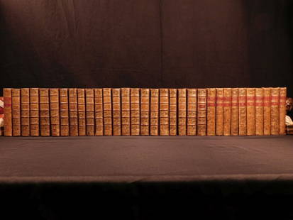
Sold20181780 1ed RARE Complete VOYAGES Maps Captain Cook Americ1780 1ed RARE Complete VOYAGES Maps Captain Cook America Explorers Africa 32v The best book of its kind! An extremely rare, 32-volume complete set of La Harpe’s ‘General History of Voyages’! ThiSee Sold Price
Sold20181780 1ed RARE Complete VOYAGES Maps Captain Cook1780 1ed RARE Complete VOYAGES Maps Captain Cook America Explorers Africa 32v The best book of its kind! An extremely rare, 32-volume complete set of La Harpe’s ‘General History of Voyages’! ThiSee Sold Price
Sold20241783 Captain James Cook Third Pacific Voyage Illustrated MAP Australia Rickman1783 Captain James Cook Third Pacific Voyage Illustrated MAP Australia Rickman “Remember, the greater the opportunity, the fewer are those who see it.” – James Cook James Cook was an 18th-ceSee Sold Price
Sold20191783 Captain James Cook Third Pacific Voyage Illustrate1783 Captain James Cook Third Pacific Voyage Illustrated MAP Australia Rickman “Remember, the greater the opportunity, the fewer are those who see it.” – James Cook James Cook was an 18th-centurSee Sold Price
Sold20181780 1ed VOYAGES Captain Cook Maps Comm Byron America1780 1ed VOYAGES Captain Cook Maps Comm Byron America Explorers Africa 3v La Harpe The best book of its kind! A rare set of La Harpe’s ‘General History of Voyages’! This extensive work was begunSee Sold Price
2017Tallis/Rapkin: Antique Map of Captain Cook's VoyageTitle/Content of Map: 'The World on Mercator's Projection shewing the voyages of Captain Cook around the World' The track's of Cook's first, second and third voyages are shown, along with dates. DateSee Sold Price
Sold20221836 1ed Oceania Rienzi Polynesia Voyages MAPS Australia Captain Cook Pacific1836 1ed Oceania Rienzi Polynesia Voyages MAPS Australia Captain Cook Pacific Louis de Rienzi was a 19th-century French voyager who is remembered for his 1836 masterwork Oceania, or Fifth Part of theSee Sold Price
Sold2022John Webber, Plates to Cook's VoyagesJohn Webber (English, 1752-1793). Plates to Cook's Voyages. 63 engravings and 2 maps. Each plate approximately: 10.25 in. high x 16 in. wide. Provenance: Collection of the Warde Family, Hooton PagnellSee Sold Price
Sold2017[Illustrated - Voyages and Exploration] James Cook's[Illustrated - Voyages and Exploration] James Cook's Third Voyage & More, Group of Prints GROUP OF ENGRAVED ILLUSTRATIONS, INCLUDING MAPS, RELATED TO COOK'S VOYAGES.See Sold Price
Sold20191836 1ed Oceania Rienzi Polynesia Voyages MAPS1836 1ed Oceania Rienzi Polynesia Voyages MAPS Australia Captain Cook Pacific Louis de Rienzi was a 19th-century French voyager who is remembered for his 1836 masterwork ‘Oceania, or Fifth Part of tSee Sold Price
Sold20191909 Discovery of North Pole Cook Peary Color1909 Discovery of North Pole Cook Peary Color Illustrated MAPS Arctic Voyages Frederick Cook was an early 20th-century American explorer most remembered for his claim of reaching the North Pole in 190See Sold Price
Sold2019Carte de l'isle O-Taïti. Tahiti, Moorea & Marquesas.TITLE/CONTENT OF MAP: '[Cook 3e Voyage] Carte de l'isle O-Taïti // Plan des Havres, situés au côté Nord d'Eimeo // Baye Matavai dans O-Tahïti // Carte des Marquises de Mendoce [Cook's 3rd VoyageSee Sold Price
Sold20181876 English Circumnavigators Voyages Cook Dampier1876 English Circumnavigators Voyages Cook Dampier Anson Map Illustrated Navigation “Ambition leads me not only farther than any other man has been before me, but as far as I think it possible for mSee Sold Price
Sold20211833 Discovery of AMERICA MAP Cabot Cartier Voyages1833 Discovery of AMERICA MAP Cabot Cartier Voyages Cook Vancouver Cortez Tytler Patrick Tytler’s “Historical View of the Progress of Discovery of America” is a rare, early 19th-century accountSee Sold Price
Sold2024Entrée de Norton & Détroit de Bhering. Bering Strait Norton Sound BONNE 1790 mapTITLE/CONTENT OF MAP: [Cook 3e Voyage] Carte de l'entrée de Norton et du Détroit de Bhering, où l'on voit le Cap le plus Oriental de l'Asie et la pointe la plus Occidentale de l'AméSee Sold Price
Sold2021Antique Map of Captain James Cook's Voyages to theAntique map of Captain James Cook's voyages to the Pacific region. Captain Cook made numerous discoveries in the Pacific region during the late 1700's . Artists and mapmakers aboard the ship, includinSee Sold Price
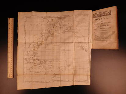
Sold20171773 Gentlemans Magazine Map Voyage South Seas Cpt CookFirst printing in original blue advertising wrapper of the Supplement issue of Gentleman's Magazine for the year 1773. Bound with the General Title and Preface and 26 pages, engraved folding plate shoSee Sold Price
18 hrs LeftTrillium Antique Prints & Rare BooksWebber & Cook, Rare - View of the Harbour of Taloo, in the Islands of Eimeo$500
18 hrs LeftTrillium Antique Prints & Rare BooksWebber & Cook, Rare - A Toopapaoo of a Chief, with a Priest Making His Offering to the Morai, in$500
Jun 07Freeman's | HindmanCOOK, James, Captain. -- [SECOND VOYAGE]. A Voyage towards the South Pole, and Round the World...$1,500
4 days LeftJasper521804 TRAVELS of Ledyard & Lucas in Africa antique w/ MAPS Voyages de MM. Lédyard$240
2 days LeftSchilb Antiquarian Rare Books1844 Harper Library United States Poland Navigation MAPS 14v Voyages RARE LOT$56(5 bids)
5 days LeftJasper52BLACK SEA Istanbul Odessa Sevastopol Sinop Varna views. TALLIS / RAPKIN 1860 map$40
5 days LeftJasper52EUROPE. Austrian Empire Prussia Poland. Slave market pic. RAPKIN/TALLIS 1851 map$100
5 days LeftJasper52SWEDEN & NORWAY. Scandinavia.Norwegian army ski regiment.TALLIS/RAPKIN 1851 map$140
5 days LeftJasper52EUROPE. Austrian Empire Prussia Poland. Slave market pic. RAPKIN/TALLIS 1851 map$100


![Carte de la rivière de Cook. Cook Inlet & Alaska coast.: TITLE/CONTENT OF MAP: '[Cook 3e Voyage] Carte de la rivière de Cook, dans la partie Nord-Ouest de l Amérique // Plan du Havre de Samgano odha, dans l'Isle de Oonalaska [Cook's 3rd Voyage - Map of Co](https://p1.liveauctioneers.com/5584/147595/74587318_1_x.jpg?height=310&quality=70&version=1565730371)
![Côte NO de l'Amérique & côte NE de l’Asie. Alaska & Kamchatka. BONNE 1790 map: TITLE/CONTENT OF MAP: [Cook 3e Voyage] Carte de la côte Nord-Ouest de l'Amérique et de la côte Nord-Est de l’Asie // Plan de l'Entrée de Nootka [Cook's 3rd Voyage - Map of th](https://p1.liveauctioneers.com/5584/310511/166159558_1_x.jpg?height=310&quality=70&version=1701205563)
![Côte NO de l'Amérique & côte NE de l’Asie. Alaska & Kamchatka. BONNE 1788 map: TITLE/CONTENT OF MAP: [Cook 3e Voyage] Carte de la côte Nord-Ouest de l'Amérique et de la côte Nord-Est de l’Asie // Plan de l'Entrée de Nootka [Cook's 3rd Voyage - Map of th](https://p1.liveauctioneers.com/5584/315733/169293401_1_x.jpg?height=310&quality=70&version=1705443824)


![[Illustrated - Voyages and Exploration] James Cook's: [Illustrated - Voyages and Exploration] James Cook's Third Voyage & More, Group of Prints GROUP OF ENGRAVED ILLUSTRATIONS, INCLUDING MAPS, RELATED TO COOK'S VOYAGES.](https://p1.liveauctioneers.com/46/113409/58240910_1_x.jpg?height=310&quality=70&version=1512492316)


![Carte de l'isle O-Taïti. Tahiti, Moorea & Marquesas.: TITLE/CONTENT OF MAP: '[Cook 3e Voyage] Carte de l'isle O-Taïti // Plan des Havres, situés au côté Nord d'Eimeo // Baye Matavai dans O-Tahïti // Carte des Marquises de Mendoce [Cook's 3rd Voyage](https://p1.liveauctioneers.com/5584/154902/78199490_1_x.jpg?height=310&quality=70&version=1574201574)


![Entrée de Norton & Détroit de Bhering. Bering Strait Norton Sound BONNE 1790 map: TITLE/CONTENT OF MAP: [Cook 3e Voyage] Carte de l'entrée de Norton et du Détroit de Bhering, où l'on voit le Cap le plus Oriental de l'Asie et la pointe la plus Occidentale de l'Amé](https://p1.liveauctioneers.com/5584/326888/175994368_1_x.jpg?height=310&quality=70&version=1713903186)


![COOK, James, Captain. -- [SECOND VOYAGE]. A Voyage towards the South Pole, and Round the World... (1 of 2)](https://p1.liveauctioneers.com/197/329395/177650491_1_x.jpg?height=282&quality=70&version=1715364962)


