Sold2023De Eylanden van Pehou' by VAN KEULEN. Penghu Islands Taiwan. VOC chart 1753 mapTitle: De Eylanden van Pehou' by VAN KEULEN. Penghu Islands Taiwan. VOC chart 1753 map Description: De Eylanden van Pehou' by Johannes van Keulen (1753). Early 18th century Dutch sea chart with old coSee Sold Price
Sold2022Faroe Islands.- North Atlantic.- Keulen (Gerard van) Nieuwe afteekening van de Eylanden van Fero,Faroe Islands.- North Atlantic.- Keulen (Gerard van) Nieuwe afteekening van de Eylanden van Fero, scarce sea chart of the Faroe Islands with north oriented to the right, rhumb lines, compass roses, soSee Sold Price
Sold2018van Keulen: Antique Map Guadeloupe & Marie Galante 1720Title/Content of Map: Nieuwe Land en Zee Kaart van de Eylanden Guadalupe en Mariegalande Cartographer: van Keulen Place & Date: Amsterdam / 1720/1780 Size: 22 1/2" x 19 7/8" Condition: b&w; overall agSee Sold Price
Sold2022KEULEN, JOHANNES VAN Pas kaart van West Indien behelsende soo deszelffs vasie kusten als d' OnderKEULEN, JOHANNES VAN Pas kaart van West Indien behelsende soo deszelffs vasie kusten als d' Onder behoorende Eylanden aan de Noord Oçeaan. Amsterdam: Johannes van Keulen, [1735]. Engraved map, haSee Sold Price
Sold2021Johannes van Keulen (Dutch, 1654-1715)Johannes van Keulen (Dutch, 1654-1715) , "Pas kaart van de Noord Kust van Espaniola met d Eylanden daar Benoorden", Amsterdam, 1684, hand-colored engraved sea-chart, with inset maps of Tortuga and PorSee Sold Price
Sold20221687 Keulen Map of North and South America's Mostly Atlantic Coastal Areas -- Pas Kaart van WestTitle: 1687 Keulen Map of North and South America's Mostly Atlantic Coastal Areas -- Pas Kaart van West Indien Behelsende soo Deszelffs Vaste Kusten als d'Onder Behoorende Eylanden aan de Noord OceaanSee Sold Price
Sold2020Map of the Dutch East Indies, 1726Heading: Author: Valentijn, François Title: Kaart van de Zuyd-Ooster Eylanden van Banda Place Published: Dordrecht Publisher:Joannes van Braam & Gerard onder de Linden Date Published: 1726See Sold Price
Sold20201684 Pas kaart Van de Caribes Tusschen I. Barbados en IThis is an authentic antique map of the Lesser Antilles by Johannes Van Keulen. The map was published in Amsterdam in the year 1684. This is an impressive hand colored example of Van Keulen’s nSee Sold Price
SoldKEULEN:KEULEN: Paskaart van de Kuste van Gualate en Arguyn. c.1715, hand-coloured: 50 x 56cm; Jansson: Erythraei Sive Rubri Maris Periplus (Asia). Amsterdam, c.1662. Hand-coloured, 38 x 46cm (2)See Sold Price
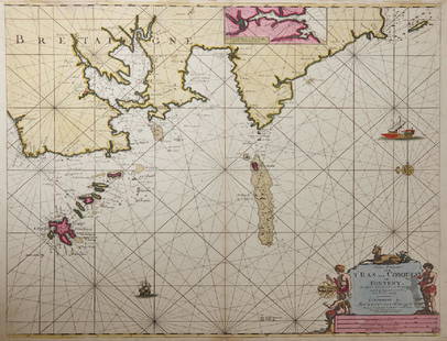
Sold2019Gerard Van Keulen (1654-1715, Amsterdam), "NieuweGerard Van Keulen (1654-1715, Amsterdam), "Nieuwe Paskaart Von T’Ras Van Conquest, on Foneny Behelsende de West Cust van Bretaignmet," hand colored, H. - 21 1/4 in., W. - 24 3/4 in.See Sold Price
Sold2022KEULEN, JOHANNES VAN Pas kaart Van de Boght van Florida Met de Canaal Tusschen Florida en Cuba Door.KEULEN, JOHANNES VAN Pas kaart Van de Boght van Florida Met de Canaal Tusschen Florida en Cuba Door. Amsterdam: Gerard Van Keulen, [1734]. Fifth state. Engraved map, hand colored, framed; sheet measurSee Sold Price
Sold2020KEULEN, JOHANNES van. Pas Kaart van de Golff vanKEULEN, JOHANNES van. Pas Kaart van de Golff van Mexico. Double-page engraved chart of the Gulf of Mexico. 21¼x24¼ inches sheet size, ample margins; light staining, small edge chips or tearsSee Sold Price
Sold2017van der Aa: Antique Explorers Map of the Atlantic OceanTitle: H. Benzos Scheep-togt uit Italie over Spanje na de Westindize Eylanden, en Kusten van't Zuider America. Lovely 1707 explorers' map set in a decorative border Map maker: Pieter van der Aa PlaceSee Sold Price
Sold2016Early Sea Chart for Triangulating. Johannes KeulenNiure Pascaart Van de Zekkusten Van Bretagne en Poictou...; Early sea chart for triangulating locations. Maker: Keulen, Johannes. Cartographer: C.J. Vooght. Origin: Amsterdam, 1697-1709. Sheet size: 2See Sold Price
Sold2023Van Keulen map of the Chesapeake Bay AreaVAN KEULEN, Johannes (1654-1715). Pas Kaart van de Zee Kuysten van Virginia. Engraved map with original hand color in part. Amsterdam, circa 1695. 20 3/4” x 24” sheet, 25” x 28 1/2&rSee Sold Price
Sold2018van Keulen: Southern Hispaniola/Northern South AmericaMap Title: Pas-kaart Van de Zuyd-Kust van Espanjola. Cartographer: van Keulen Place & Date: Amsterdam / 1682 Size: 23" x 20" Condition: outline color (wash in cartouche); top margin trimmed close; ligSee Sold Price
2017van Keulen: Antique Sea Chart of South Hispaniola, 1682Map: Pas-kaart Van de Zuyd-Kust van Espanjola Cartographer: van Keulen Place & Date: Amsterdam / 1682 Size: 23" x 20" Condition: outline color (wash in cartouche); top margin trimmed close; light overSee Sold Price
Sold2021Jan Van de Berg "The Island" in wax pastelJan Van de Berg "The Island" Grasmere Lake district in wax pastel. Overall 15 1/4"h x 19 3/4"w, sight size 8 1/4"h x 13"wSee Sold Price
Sold2022ROCHEFORT, CHARLES DE Natuurlijke en Zedelijke Historie der Voor-Eylanden van Amerika. Rotterdam:ROCHEFORT, CHARLES DE Natuurlijke en Zedelijke Historie der Voor-Eylanden van Amerika. Rotterdam: Arnout Leers, 1662. First Dutch Edition, preceded by the French edition issued in Rotterdam, 1658. ConSee Sold Price
Sold2024MAP, Africa, SansonWestern Africa, Cape Verde Islands. Nicolas Sanson, D'Eilanden van Capo Verde, de Kust en't Landt der Negeren..., from Algemeene Weereld-Beschryving…, 1705 (published). Hand Color. This is an attracSee Sold Price
Sold2019MAP - East Indies - Indonesia. TirionEast Indies - Indonesia. Isaac Tirion, Kaart van de Papoasche Eilanden, 1753 (dated). Hand Color. This beautifully engraved chart spans from the Spice Islands (Sallawatty, Patenta, Gammen, Land van WaSee Sold Price
Sold201519th C. Oil on Wood Panel. Ships in Dutch Harbor.Inscribed ' Van de Velde' in ink verso. In the manner of William Van de Velde II (Dutch, 1633 - 1707). From a Long Island, NY estate. Dimensions: 8.75" high x 11.75" wide. Condition: Slight toning toSee Sold Price
Sold20201699 D’Eilanden van Capo Verde, de Kust en’t Landt derThis attractive antique hand-colored map features the Cape Verde Islands off the west coast of Africa, and a portion of the coast of western Africa including Muritaniya, Cape Verde, Gambia, and SenegaSee Sold Price
Sold2024James Cook - Antique map Australia titled 'Gezigt van het Eil. Suffren'. Antique map of SuffrenAntique map Australia titled 'Gezigt van het Eil. Suffren'. Antique map of Suffren Island. Originates from 'Reizen Rondom de Waereld door James Cook (..)'. Artists and Engravers: Translated by J.D. PaSee Sold Price
24 hrs LeftJasper521625 Gerritsz Map of the Paraguay River Basin -- Paraguay, o Prov. de Rio de la Plata: me de$160
1 day LeftBonhamsLINO TAGLIAPIETRA (1934) Vase asymétriquePièce unique1987Signé et daté 'Lino...€800
Jun 13Eldred'sVAN CLEEF & ARPELS STYPTOR AND TWO-TONE GOLD MINAUDIERE Circa 1940 Height 5". Width 6.25".$750
8 hrs LeftCarlo Bonte AuctionsTheophile Marie Francoise Lybaert (1848-1927), 'Gent, Rijkste Diamant in de kroon van Vlaanderen',€1,500(1 bid)
8 hrs LeftCarlo Bonte AuctionsPol Spilliaert (1935-2023), 'In 't midden van de tuin', patinated bronze, 2010 85 x 90 x 32 cm.€3,000
8 hrs LeftCarlo Bonte AuctionsPol Spilliaert (1935-2023), 'In 't midden van de tuin', polished bronze, 2010 56 x 63 x 27 cm. (22.0€3,000
8 hrs LeftCarlo Bonte AuctionsPol Spilliaert (1935-2023), 'In 't midden van de tuin', bronze patinated polyester€1,200
8 hrs LeftCarlo Bonte AuctionsPol Spilliaert (1935-2023), 'De val van Icaros' aka 'Vita Brevis', Portuguese Rose Aurore marble 66€1,200


![KEULEN, JOHANNES VAN Pas kaart van West Indien behelsende soo deszelffs vasie kusten als d' Onder: KEULEN, JOHANNES VAN Pas kaart van West Indien behelsende soo deszelffs vasie kusten als d' Onder behoorende Eylanden aan de Noord Oçeaan. Amsterdam: Johannes van Keulen, [1735]. Engraved map, ha](https://p1.liveauctioneers.com/292/250642/130213616_1_x.jpg?height=310&quality=70&version=1654271664)


![KEULEN, JOHANNES VAN Pas kaart Van de Boght van Florida Met de Canaal Tusschen Florida en Cuba Door.: KEULEN, JOHANNES VAN Pas kaart Van de Boght van Florida Met de Canaal Tusschen Florida en Cuba Door. Amsterdam: Gerard Van Keulen, [1734]. Fifth state. Engraved map, hand colored, framed; sheet measur](https://p1.liveauctioneers.com/292/250642/130213613_1_x.jpg?height=310&quality=70&version=1654271664)


