Sold2020De Wit Map of Africa ca. 1685Frederick de Wit (ca. 1630 – 1706), "Totius Africae Accuratissima Tabula," Amsterdam, ca. 1685. Hand colored map of Africa. African animals are included throughout the continent, and the decoraSee Sold Price
Sold2017De Wit Map of AfricaTotius Africa Accuratissima Tabula. Frederick de Wit (1629/1630-1706). Engraved map with original hand color. Amsterdam, c. 1660. 19 1/4 x 23 inches visible, 24 3/4 x 28 1/2 inches framedSee Sold Price
Sold2022MAP- Frederick De. Wit:MAP- Frederick De. Wit: MAP- Frederick De. Wit: NOVISSIMA PRAE CETERISALIIS ACCURATISSIMA REGNORUM ANGLIAE SCOTIAE HIBERNIAE. Ca. 1690, hand coloured and laid down (560x490mm)See Sold Price
Sold2020Grp: 3 Maps of the Coast of AfricaGroup of three maps of the west coast of Africa by Guillaume Rouille (ca. 1518–1589): "Carte Reduite des Costes Occidentales d'Afrique," 1753; "Carte Generale de la Coste de Guinee," 1750; andSee Sold Price
Sold2022De Wit, Map of North and South America, c. 1720Property of a Private Collector, Hilton Head Island, SC Description: Frederick De Wit (circa 1629-1706), Nova Orbis Tabula In Lucem Edita, A.F. De Wit, Amsterdam: Covens and Mortier, c. 1720, publSee Sold Price
Sold2017de Wit: Map of Southeast Asia, 1670Map: Tabula Indiae Orientalis Cartographer: Frederick De Wit Place & Date: Amsterdam / 1670 Size: 22 1/4" x 18 1/4" Condition: light overall age-toning A highly decorative and beautifully colored lateSee Sold Price
Sold2019De Wit Map of HungaryDE WIT, Frederick (1630-1706). Regni Hungariae, et Regionum, quae ei Quondam Fuere Unitae, ut Transilvaniae, Valachiae, Moldaviae, Serviae, Romaniae, Bulgariae, Bessarabiae, Croatiae, Bosniae, DalmatiSee Sold Price
Sold20211690 de Wit Map of Saxony Germany -- Circuli SaxoniaeTitle: 1690 de Wit Map of Saxony Germany -- Circuli Saxoniae Superioris pars meridionalis… Cartographer: F de Wit Year / Place: 1690 c. , Amsterdam Map Dimension (in.): 19.2 X 22.1 in. This is aSee Sold Price
Sold2023De Wit Map of Hungary and Surrounding Regions.This early map is Matted and mounted to a cardboard backing. The Map is dated 1686. It Looks to be in overall Good condition, with some minor Scratches. There are crease marks from when it was folded.See Sold Price
Sold2023De Wit Map of Zeeland, HollandDE WIT, Frederick (c. 1630-1706). Comitatus Zelandiae tabula... Engraved map with original hand color. Amsterdam, c. 1680. 21 1/2" x 24 3/8" sheet, approx. Antique Map of Zeeland, Netherlands showingSee Sold Price
Sold2023Frederik De Wit Map of Hungary and the Balkans.This antique hand-colored map is matted and mounted to a cardstock backing. The map is dated 1686, and is accredited to Frederici (Frederik) de Wit. The text is in Latin. It looks to be in overall gooSee Sold Price
Sold2024Frederik De Wit Map Of SpainIn the region of Catalonia and the counties of Ruscinone and CerretaniaSee Sold Price
Sold20191662 deWit Map of Southeast Asia -- Tabula IndiaeReserve Reduced! Title/Content of Map: 1662 deWit Map of Southeast Asia -- Tabula Indiae Orientalis Date: 1662, Amsterdam Cartographer: F de Witt Size: 18 X 22.2 in. This is a outstanding larger map oSee Sold Price
Sold20221680 deWit Map of Asia -- Accuratissima Totius AsiaeTitle: 1680 deWit Map of Asia -- Accuratissima Totius Asiae Tabula Recens Emendata Cartographer: F de Wit Year / Place: 1680 c. Amsterdam Map Dimension (in.): 19.3 X 22.9 in. This is a lovely large maSee Sold Price
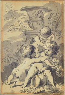
Sold2016Jacob de WittJacob de Wit, ca. 1695-1754, three cupids on agarden vase, pen and ink drawing on paper, signed on the back, about 18x12cm, under glass, frameSee Sold Price
Sold2021Eleven Antique Maps of EuropeEleven Antique Maps of Europe , 16th-18th c., incl. Ptolemy from 1541 (4); a Blaeu map of "Regno di Napoli", Hondius map of the Holy Land, de Wit map of Southern Spain, an undated manuscript map of MeSee Sold Price
Sold2017de Wit: Antique Map of Portugal & Parts of Spain, 1690Title/Content of Map: 1690 de Wit Map of Portugal and Parts of Spain -- Tabula Portugalliae et Algarbia Date Printed: 1690, Amsterdam Cartographer: F de Wit Size: 18.5 x 22.2 in. Condition: Good. ExceSee Sold Price
Sold2024Two Antique Maps of the Arabian PeninsulaProperty from the Estate of a Swiss UBS Executive, Zurich and Hilton Head Island, SC Description: Two Antique Maps of the Arabian Peninsula , E. de Wit map of 'New Persia, Armenia, Anatolia and ArSee Sold Price
Sold2020Herman Moll Map of Africa ca. 1720Herman Moll (ca. 1654-1732). Map of Africa, London, ca. 1720. With an elaborate dedication cartouche reading "To the right honourable Charles, Earl of Peterborow and Monmouth, etc this map of Africa aSee Sold Price
Sold2021FREDERIK DE WIT Zealand MapFREDERIK DE WIT Zealand Map, inscriptions to piece in Latin, subject an overhead map, measures 21 1/8 x 24 5/8 inches, yellow wooden frame, surface wear to frame, broken glass to lower portion of piecSee Sold Price
Sold2023[MAP] DE WIT, F. NOVA ORBIS TABULA IN LUCEM EDITAde Wit, Frederik. NOVA ORBIS TABULA, IN LUCEM EDITA. (Amsterdam: circa 1670s.) Beautiful map in exquisite full handcolouring, with elaborate corner scenes illustrating the four seasons and the Zodiac,See Sold Price
Sold2023Carte de L'Afrique. Map of Africa. Takrur Guinea Congo. MALTE-BRUN c1871TITLE/CONTENT OF MAP: 'Carte de l'Afrique [Map of Africa]' DATE PRINTED: c1871 IMAGE SIZE: Approx 35.0 x 45.0cm, 13.75 x 17.75 inches (Large); Please note that this is a folding map. TYPE: Antique 19tSee Sold Price
Sold2022Rare 1818 Map Showing the Battle of Bunker Hill Sketched by Witness Henry de BerniereRare 1818 Map Showing the Battle of Bunker Hill Sketched by Witness Henry de Berniere Engraved map, Ca. 1818, Charlestown, MA. Entitled "Sketch of the Action on the Heights of Charlestown 17 June 1775See Sold Price
Sold2017(MAP, SICILY) DE WIT, FREDERICK. Insula sive regnumMAP, SICILY by DE WIT, FREDERICK, Insula sive regnum Siciliae urbibus praecipuis exornatum. Amsterdam, circa 1680. Hand-colored engraved map of Sicily. With inset plans of Messina, Milazzo and PalermoSee Sold Price
BonhamsWEST AFRICA DE WIT (FREDERICK) Tractus Littorales Guineae a Promontorio Verde usque ad Sinum Cat...£10
BonhamsAFRICA DE WIT (FREDERICK) Totius Africae Accuratissima Tabula,Amsterdam, Frederick de Wit, [c.16...£10
BonhamsEAST AFRICA DE WIT (FREDERICK) Occidentalior Tractus Indiarum Orientalium a Promontorio Bonae Sp...£300
5 days LeftJasper52Carte de la partie septentrionale d'Afrique, ou de la Barbarie… BONNE 1780 map$25
5 days LeftJasper52L'Afrique Françoise ou du Senegal'. French West Africa. DE L’ISLE 1727 map$100
Featured5 days LeftJasper52La Barbarie de la Nigritie et de la Guinée'. West Africa. DE L’ISLE 1745 map$130
5 days LeftJasper52Côte occidentale de l'Afrique. W Africa.Senegal Gambia rivers.D’ANVILLE 1751 map$85
Jun 08Trillium Antique Prints & Rare BooksCluver & De L'Isle - Map of the Eastern Hemisphere (Europe, Asia, Africa and part of Australia)$75
Featured5 days LeftJasper52Coste Orientale d’Afrique…' East Africa Kenya Tanzania Somalia. BELLIN 1746 map$80
5 days LeftJasper52Le Canal de Mosambique, l'Isle de Madagascar… Mozambique. Africa. BONNE 1788 map$15
5 days LeftJasper52Le Canal de Mosambique, l'Isle de Madagascar… Mozambique. Africa. BONNE 1790 map$20
5 days LeftJasper52Coste Orientale d’Afrique…' South Africa. Mozambique channel. BELLIN 1746 map$25
5 days LeftJasper52SOUTHERN AFRICA Monomotapa (Mutapa Kingdom) Cafrerie (Kaffraria) MALLET 1683 map$30
Featured5 days LeftJasper52Coste Occidentale d’Afrique…' Namibia South Africa Angola coast BELLIN 1746 map$45
5 days LeftJasper52Coste Occidentale d’Afrique…' West Africa. Gulf of Guinea. BELLIN 1746 map$55
5 days LeftJasper52Partie Occidentale de l’Afrique. West Africa coast Canary islands BONNE 1788 map$15
5 days LeftJasper52Guinea-Bissau Cacheu town Fortaleza de São José da Amura Preparing cassava 1745$10


![[MAP] DE WIT, F. NOVA ORBIS TABULA IN LUCEM EDITA: de Wit, Frederik. NOVA ORBIS TABULA, IN LUCEM EDITA. (Amsterdam: circa 1670s.) Beautiful map in exquisite full handcolouring, with elaborate corner scenes illustrating the four seasons and the Zodiac,](https://p1.liveauctioneers.com/8124/310027/165853624_1_x.jpg?height=310&quality=70&version=1700184289)
![Carte de L'Afrique. Map of Africa. Takrur Guinea Congo. MALTE-BRUN c1871: TITLE/CONTENT OF MAP: 'Carte de l'Afrique [Map of Africa]' DATE PRINTED: c1871 IMAGE SIZE: Approx 35.0 x 45.0cm, 13.75 x 17.75 inches (Large); Please note that this is a folding map. TYPE: Antique 19t](https://p1.liveauctioneers.com/5584/308981/165185437_1_x.jpg?height=310&quality=70&version=1699996168)


