Sold2021Detailed Map of TransylvaniaSteel engraved colored map of Transylvania from "Meyer s Handatlas" published by Hauptmann Radefeld in 1849. The map shows many cities, villages with political regions handcolored in outline. Dimm_:40See Sold Price
Sold2022A RARE 18TH CENTURY MAHOGANY FRAMED LARGE TRIPLE FOLDING SCREEN DEPICTING A DETAILED MAP OF THE CITYA RARE 18TH CENTURY MAHOGANY FRAMED LARGE TRIPLE FOLDING SCREEN DEPICTING A DETAILED MAP OF THE CITY OF LONDON from a bound volume of the Cities of London and Westminster and Southwark and ten-mile raSee Sold Price
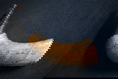
Sold2023Powder Horn with a very detailed map engraved of Northern Illinois and Eastern Iowa. Also hasPowder Horn with a very detailed map engraved of Northern Illinois and Eastern Iowa. Also has Harold Smith engraved in it.See Sold Price
Sold2021Ukraine, one of the earliest detailed maps of theTitle: Ukraine, one of the earliest detailed maps of the country. 1762 by Homann Heirs Date/Period: 1762 Materials: Copperplate engraved Size: 24 x 20 1/2" The best detailed early map of the region. SSee Sold Price
Sold2018France.- Ortelius (Abraham) Gallia, detailed map ofFrance.- Ortelius (Abraham) Gallia, detailed map of France, with part of southern England, northern Italy, and includes Belgium and the Netherlands, a large title cartouche with two putto decorating tSee Sold Price
2020Ukraine, one of the earliest detailed maps of theTitle: Ukraine, one of the earliest detailed maps of the country. 1762 by Homann Heirs Date/Period: 1762 Materials: Copperplate engraved Size: 24 x 20 1/2" The best detailed early map of the region. SSee Sold Price
Sold2022Large detailed map of Gulf of Venice, 1693Heading: Author: Jaillot, Alexis-Hubert Title: Le Golfe De Venise, Avec ses Principaux Caps, Promontoires, & Ports de Mer Place Published: Paris Publisher: Date Published: 1793 DescripSee Sold Price
Sold20241694 Alexis-Hubert Jaillot Highly Detailed Map Of ItalyMap of Italy, the Adriatic, Mediterranean and contiguous islands, including Corsica, Sardinia and SicilySee Sold Price
Sold2020Barbados. RARE detailed mapTitle: Barbados. RARE detailed map Date/Period: 1729-1736 Materials: Copperplate engraved Dimensions: 16 1/4 x 12 1/3” By. H. Moll. From. Atlas minor. Published. London. Reserve: $200.00 Shipping:See Sold Price
Sold2020Caspian Sea. Detailed map. Best to dateTitle: Caspian Sea. Detailed map. Best to date Description: By. Herman Moll. From. Atlas minor. Published. London. Date/ Period: 1729-1736 Materials: Copperplate engraved. Dimensions: 13 1/2 x 9 “ RSee Sold Price
Sold2024The Kennebunk region: a guide to churches, historic points, famouslandmarks: a detailed map ofTitle: The Kennebunk region: a guide to churches, historic points, famouslandmarks: a detailed map of coast, rivers and highways including historical facts and legends Author: Edward Mayo (CartographeSee Sold Price
Sold2023Atlas Maior, vol 4, map 45 - Joan Blaeu, 1667 Antique Copper Engraving Detailed Map. Rhenolandiae etAtlas Maior, vol 4, map 45 - Joan Blaeu, 1667 Antique Copper Engraving Detailed Map. Rhenolandiae et Amstellandiae exactißima Tabula. Original antique copper engraving, hand colored in outline andSee Sold Price
Sold2018Bellin: Detailed Map of the Mexican HeartlandReserve Reduced! Title of Map: Carte du Mexique Cartographer: Bellin Place/Date: Paris / 1754/1760 Size: 11 3/8" x 8 1/4" Condition: b&w; light overall age toning and some minor stains; a tiny repaireSee Sold Price
Sold2023Detailed map of England from Meyer’s 1850 Zeitung’s AtlasFinely detailed map of the lower UK dated 1850. Original outline hand coloring. A lighter impression. Some soiling, mostly in margins. 8.5 x 10.125 Reserve: $50.00 Shipping: Domestic: Flat-rate of $5.See Sold Price
Sold2020SDUK: Detailed Map of Ancient Italy in 3 SheetsMap Title: Ancient Italy I, II, and III Cartographer: Baldwin & Cradock, Society for the Diffusion of Useful Knowledge Place/Date: London / 1832/1852 Size: 14 7/8" x 11 1/4" (largest of the three mapsSee Sold Price
Sold2020SDUK: Detailed Map of Spain in 3 SheetsTitle/Content of Map: SDUK: Detailed Map of Spain in 3 Sheets Date Printed: 1831/1852, London Cartographer: Baldwin & Cradock, Society for the Diffusion of Useful Knowledge Size: 14 3/4" x 11 3/4" (laSee Sold Price
Sold20231784 Detailed Map of Turkey in EuropeA New Map of Turkey in Europe, published by Harrison and Co., London 1784. Very Good, light offset, folds as issued, measures 10 x 16". Reserve: $20.00 Shipping: Domestic: Flat-rate of $6.00 to anywheSee Sold Price
Sold2018Belgium (Called Netherlands on Map) Large detailed MapBelgium (Called Netherlands on Map) Large detailed Map c1817 Thomson 20" x 26 3/4" Published in Edinburgh Scotland. Hand colored, copperplate engraved. Please note that this lot has a confidential resSee Sold Price
Sold2022China.- Ortelius (Abraham) Chinae, olim Sinarum regionis, nova descriptio, 1584 [but slightlyChina.- Ortelius (Abraham) Chinae, olim Sinarum regionis, nova descriptio, detailed map centred on China and based on the work of Jorge de Barbuda, a Portuguese Jesuit also known as Ludovicus GeorgiusSee Sold Price
Sold2022MACLEOD, Alexander Samuel (1888-1956). A Map of Honolulu an...MACLEOD, Alexander Samuel (1888-1956). A Map of Honolulu and the Sandwich Islands which we now call the Hawaiian Islands. 1927. New York: Henry M. Snyder. Scarce and detailed map of Honolulu, with anSee Sold Price
Sold2019Malta.- Brocktorff (Luigi) Map of Malta and itsMalta.- Brocktorff (Luigi) Map of Malta and its dependencies, detailed map including Comino and Gozo, surrouned by 13 vignettes showing regional sights of interest, British Royal coat of arms in the lSee Sold Price
Sold2022Africa.- Ortelius (Abraham) Africae Tabula Nova, engraved map, [c.1570-1612].Africa.- Ortelius (Abraham) Africae Tabula Nova, detailed map of Africa based upon Gastaldi's 8 sheet wall map and Mercator's world map of 1569, decorated with a strapwork title cartouche, a sea battlSee Sold Price
Sold2017Moll: A New Map of ye North Parts of America,1729Map: A New Map of ye North Parts of America... Maker: H. Moll Date: 1729 (1730-32) Description: A highly detailed map depicting French America along with English and Spanish territories and showing aSee Sold Price
Sold2022Important map of Baja California and today’s Arizona c1765. By TirionTitle: Important map of Baja California and today’s Arizona c1765. By Tirion Date/Period: c1765 Materials: Copper plate engraved Size: 14 x 13” AMONG THE BEST AND OLDEST DETAILED MAPS OBTASee Sold Price
6 days LeftHolabird Western Americana CollectionsEngraved Map of Netherlands, Zuphaneinsis, c1645 [180170]$200
3 days LeftJasper521893 Civil War Map of Siege of Yorktown, Battle of Siloh and Army of Ohio Operations -- Plan of$55
3 days LeftJasper521893 Civil War Map of Knoxville Area -- Topographical Map of the Approaches and Defences of$70
3 days LeftJasper521893 Civil War Map Washington, Paducah, KY and Logan's Cross-Roads plus Mill Springs, KY -- Defenses$70
3 days LeftJasper521893 Civil War Map of Yorktown -- Secession Works at Yorktown [with] The Position of Yorktown with$55
3 days LeftJasper521760 d'Anville Map of France during Roman Times -- Gallia Antiqua Ex Aevi Romai Monumentis Eruta et$60
3 days LeftJasper521733 c. DeLisle Map of Ancient Northern Greece -- Graeciae Pars Septentrionalis$95
6 days LeftHolabird Western Americana CollectionsMaps of Spain, France, & Portugal, c1800s (3) [180172]$100
7 days LeftLeon GalleryVincenzo Maria Coronelli (1650-1718) - Asia Divisa Nelle sue Parti Secondo lo Stato Presente₱220,000


![Africa.- Ortelius (Abraham) Africae Tabula Nova, engraved map, [c.1570-1612].: Africa.- Ortelius (Abraham) Africae Tabula Nova, detailed map of Africa based upon Gastaldi's 8 sheet wall map and Mercator's world map of 1569, decorated with a strapwork title cartouche, a sea battl](https://p1.liveauctioneers.com/5458/269991/141255679_1_x.jpg?height=310&quality=70&version=1669303305)


![Engraved Map of Netherlands, Zuphaneinsis, c1645 [180170] (1 of 2)](https://p1.liveauctioneers.com/2699/331495/178785773_1_x.jpg?height=282&quality=70&version=1717094933)
![Engraved Maps of Spain, c1650's (2) [180169] (1 of 3)](https://p1.liveauctioneers.com/2699/331495/178785774_1_x.jpg?height=282&quality=70&version=1717094933)


![1893 Civil War Map of Yorktown -- Secession Works at Yorktown [with] The Position of Yorktown with (1 of 1)](https://p1.liveauctioneers.com/5584/331064/178466378_1_x.jpg?height=282&quality=70&version=1716924723)


![Maps of Spain, France, & Portugal, c1800s (3) [180172] (1 of 6)](https://p1.liveauctioneers.com/2699/331495/178785790_1_x.jpg?height=282&quality=70&version=1717094933)

